Contributor Leaderboard
-
.jpg.cdd7f8371d17e2f2f2e2a0e21e02f727.jpg) 6Points3,645Posts
6Points3,645Posts -
James
Members2Points213Posts -
lilbill15
Members2Points409Posts -
HIGH PIT WILMA
Members1Points1,519Posts
.thumb.jpg.7493ddab4a696108cf2b849323d3c155.jpg)


Popular Content
Showing content with the highest reputation on 25/05/21 in Posts
-
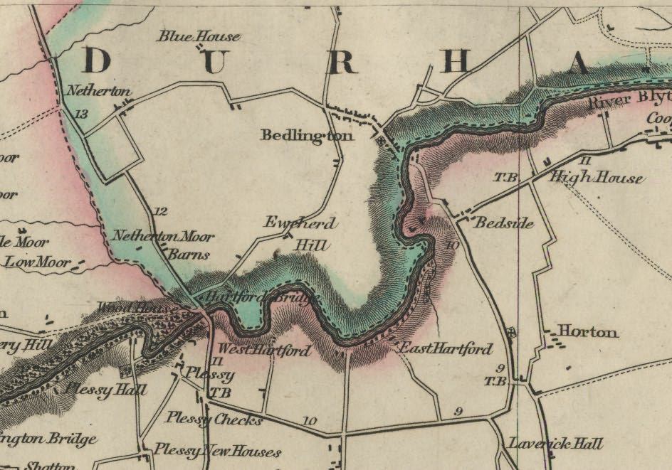
2 pointsNow, I've located the map I was looking for! Ewe herd Hill goes back much further than 1820. here it is on what, according to me, is a very beautiful map of the area from 1769:
 2 points
 -
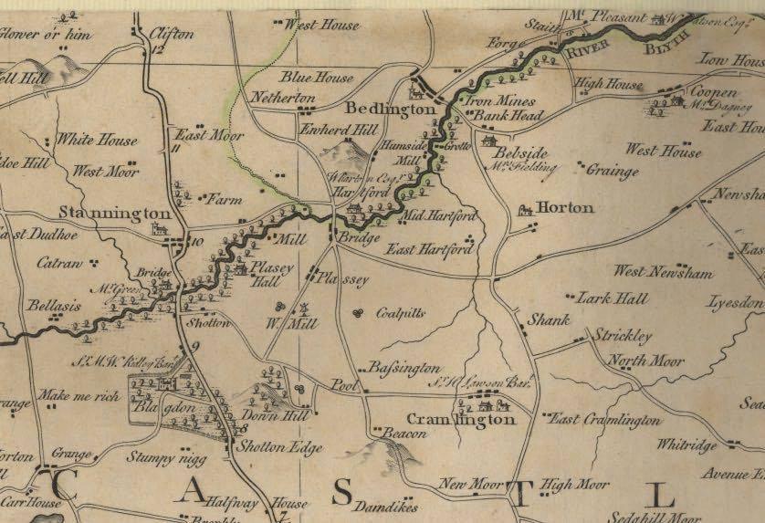
2 pointsApropos Ewart Hill, did you know that it was originally called Ewe herd Hill? I've always thought of Ewart as family name but Ewe herd Hill was clearly a way of describing a landscape feature ( a hill where there were shepherds living or working). Here it is on Fryer's map of 1820:
 2 points
 -
1 pointThese are my favourites: https://www.old-maps.co.uk/ https://www.oldmapsonline.org/ https://maps.nls.uk/ https://www.visionofbritain.org.uk/maps/ Enjoy!1 point
-
1 point1 point1 point@HIGH PIT WILMA if you haven’t published yet it’s high time you did. Your beautiful description of the site and especially the movement of the machine is almost poetic, while reading it I could see it as if I was there. Who needs dvds when such graphic written records are available. I’ll be looking for more of your posts during my rummagings in Bedlington then and now, if that’s ok. x1 point1 pointIt was coal in the trucks not waste, The waste (overburden) from the opencast was put back in the “hole” and the raw coal transported to Bedside Colliery wash plant for cleaning. The photo shows the first Costain truck on the bridge.
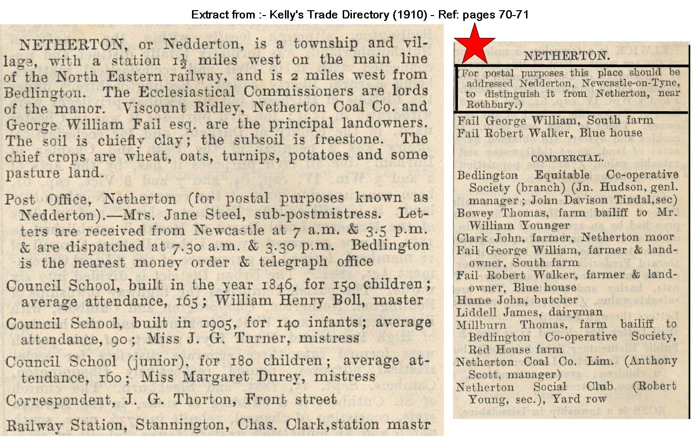
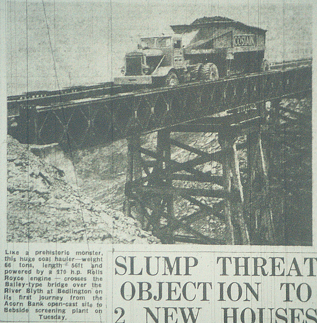 1 point1 pointTry having a look at another topic on this forum: https://www.bedlington.co.uk/forums/topic/3197-ewart-hill-opencast/ HPW gives a good description of the wooden trestles of the bridge being built in 1954. There's a lot of information about the workings at Acorn Bank as well.1 point1 pointI have no dates of the years that the Ewart Hill pit was in operation but the map shows it was disused in 1897. It had only one shaft 361 ft. deep and worked the Low Main Seam. Following the Hartley Colliery disaster in 1862 when 204 men and boys died of carbon monoxide poisoning, all collieries had to have at least 2 shafts so that in the event that one shaft was out of action or damaged in some way there was a second shaft for the underground workers to use as a means of escape. I assume from this that it must have closed before 1862. If anyone can download an earlier map of the Ewart hill area it may give some idea of when it was in operation. Long after the Ewart Hill Pit had closed, the Doctor Pit mined a connecting roadway to the shaft in the Low Main seam workings and used it as a downcast ventilation shaft. You can see the shaft “cap” (a concrete cover) from the road as you walk past the farm The photo shows the Low Ewart Hill farm that was demolished in the 1950's and the coal beneath it mined by the opencast. At the same time the road that used to pass this farm was diverted. This area is now the golf course.
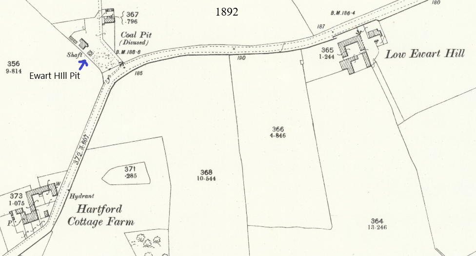 1 point1 pointThank you very much Alan, I shared these pics with Josephine and she’s chuffed to see them, she’s sure she saw this bridge back in the day. We’re planning a trip to Woodhorn with the dogs to combine their run and swim with our visit to the museum- another very useful steer, thank you very much kind sir x1 point1 pointHeh heh!..not nitpicking,maybe just a regional variation in dialect,but in old Choppington,and Bedlington,we said,[and still do say...].."Hunkaas". ...."a was sittin' on me hunkaas,when a greet bliddy clemmy dropped oot atween thi gordaa's....mind,it sartinly med is cowp me creels ti get oot thi way...!!" Yi knaa wat, folks?,aad age teks it toll,cos noo a canna sit on me hunkaas for a minute,or even on me knees like a wad in a low seam,if a dae, a canna get back up!.....PAINS.....AAAAHHHHGGGGG!!!1 point