
Contributor Leaderboard


Popular Content
Showing content with the highest reputation on 01/10/23 in all areas
-
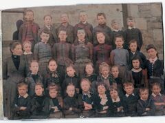 Coach Road is shown in blue on the attached 1897 map of Bedlington East End. The road is still there leading to Spring view and the last houses were demolished in the early 1950’s. The East End Church of England school was only about 250 yards from Coach Road so is fair to assume that this is the school in the photo. The school (shown in yellow on the map) was closed in the early 1900’s and the site is now part of Hollymount Square.3 points
 -
I think the school may well be the Village School, as looking at a photograph from more recent times (before demolition) the brickwork does seem to match.1 point
-
it was Coach Road, not Row. I feel like I am getting closer to finding out which school it is. I feel like the brickwork looks similar to the Village School / Vulcan school. If my great great grandfather was 4 in 1891, and I would say he looks between 4 and 6 on this photo, it would suggest it was taken around 1891-18931 point
-
@carly I'll see if i can find Coach Row on any of the old maps and if I can find it it should give us a clue to what school they went to.1 point
-
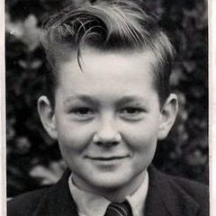
Thank you so much for looking into this for me. The little boy on the bottom row, third from the right is my great, great Grandfather David Waddell. On the 1891 census he was 4 years old and was living on Coach Road in Bedlington. I am not 100% sure, but believe that his older sister Mary is on this photograph too. I think she is the girl on the second row down, second in after the little boy standing next to the teacher with the curled under fringe. In 1891 she would have been 12.1 point
-
@carly - we don't have any school photos from the 'late 1800s' and I can't find a photo with brickwork that completely matches the brickwork in your photo. I have only ever found three schools that were in the area in the 1800's. They are :- 1. The Village school, opened 1874, on Church Lane Bedlington (flats now built on the land) 2. Bedlington station Colliery school. Don't know when it was built but it is identified on on and 1859 OS map. This area used to be named Sleekburn but changed it's name to Bedlington Station after the Bedlington railway station was built in Sleekburn. 3. On an 1896 OS map a school is identified in Bell's Place in Bedlington. Unfortunately no image of this school have ever been posed on any of the local groups. This is a compilation of your photo + Bedlington Village School photo + Bedlington Station Colliery school photo :- This is the only reference, 1896 map, to the school in Bell's Place + a Goole Street view of the area now - Bedlington's East End area :- I would guess you are researching your family. Do you have any info on where they lived in Bedlington?1 point
-
@carly - I keep a copy of all the school photos where the names have been added so I will have a scan through them all and see if I can find a photo with a similar background. I will let you know weather I find a match or not but I don't recognize it.1 point