.jpg.cdd7f8371d17e2f2f2e2a0e21e02f727.jpg)
.jpg.a8059e59bff91bf6691d0bfedf8fad60.jpg)
Canny lass
-
Posts
3,642 -
Joined
-
Last visited
-
Days Won
436
Content Type
Forums
Gallery
Events
Shop
News
Audio Archive
Timeline
Everything posted by Canny lass
-
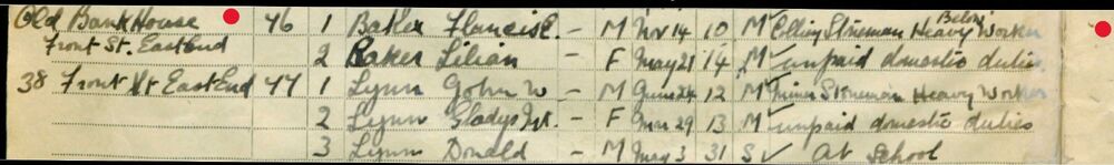
First and foremost, we can see that in 1939 Bank House was no longer in the possession of the Gibson family. It was now occupied by a mining family and, it seems to me, that the following family (at nr. 38) is living in the same building so possibly converted into flats. To come back to the youngest of the brothers, Philip Hedley Gibson, he seems to have continued in the field of selling. No doubt fuelled by his experience in the shop at Bank House, he has moved his family to the bright lights of Wandsworth, London where he is employed, not in any managerial position but as a salesman in a hardware department of a, presumably, larger, London store. Could one of his older brothers have taken on the ironmongers business in Bedlington? Unfortunately not. Brother William Henry Gibson continued to live on Rothesay Terrace but now at number 105. His occupation is then given as “Air Raid Precaution Clerk” with “Bedlington U, D, Council” so he has, presumably left the drapery business. Note that nr. 106 is vacant (V in margin). The place is not unoccupied but the resident is not available.

- 20 replies
-
- 1
-

-
- furnace
- vulcan place
- (and 2 more)
-
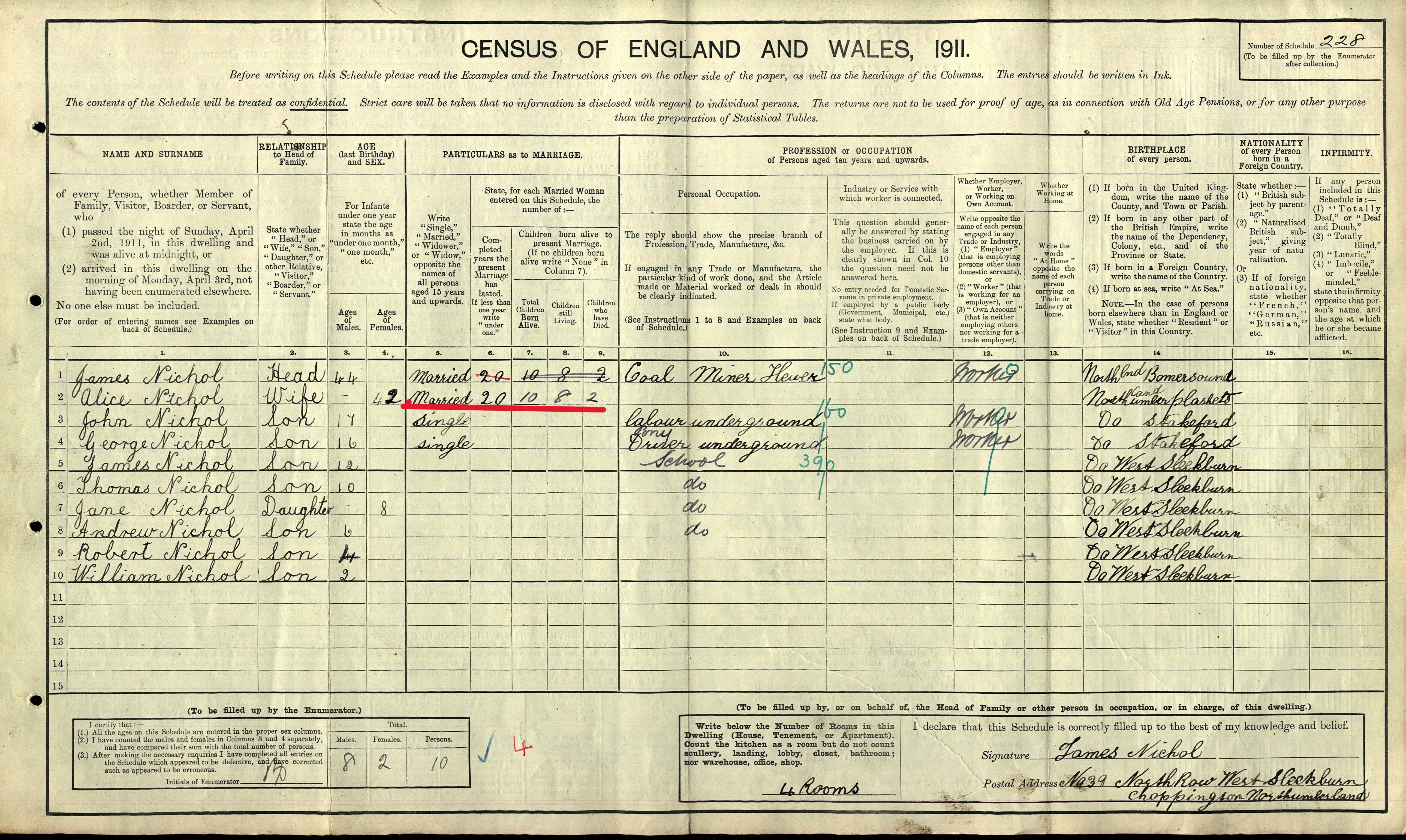
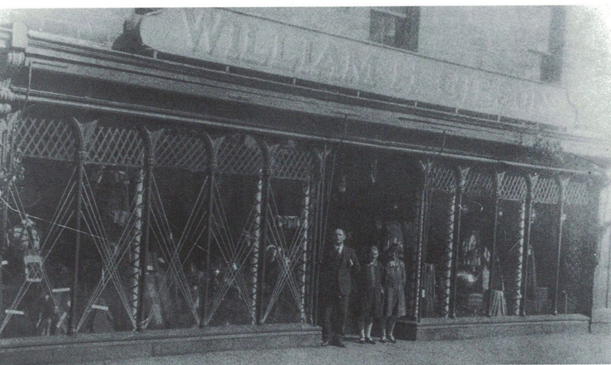
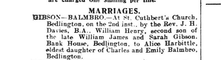
There has been very little information available after the 1911 census for the Gibson family but thanks to the release of the 1921 census research has now been made a little easier. In 1911 both Philip Hedley Gibson and his brother, Edward Mostyn Gibson were involved, albeit on different levels, with ironmongery. Edward M was, together with his father, joint manager in the ironmongery business. Philip H was working for them as an apprentice shopkeeper in the family shop at Bank House. After the death of their father, Edwin Mostyn takes over the management of the ironmongery business while continuing with his banking interests. Both Edwin and Philip are single and living at Bank House. In 1917 Edwin Mostyn marries. His bride is Mabel Robinson Turner of Blyth and she moves to her husband’s home. Three years later, in June 1920, Philip Hedley also marries and also brings his wife, Jean Balmbro, to Bank House. Jean appears to be the sister of his brother William Henry’s wife. Note: The name “Jean” would appear to be a misprint as her name is given as “Jane A” in the marriage index and as “Jane Ann” in the 1921 census. One year later, in 1921 the two sons and their wives are sharing the 10 rooms of Bank House. Philip H has completed his apprenticeship and is now entitled to call himself an ‘ironmonger’. He is stated to be an “employer” (rather than a worker, as previously) so seems to be in a managerial position in the business – if not the sole owner. I say the latter because his brother, Edward Mostyn, gives his occupation only as “Bank Manager” and his “employer” as “Bank of Liverpool and Martins Ltd.” but I can see from Kelly’s Directory that he is also engaged as “treasurer of the Urban District Council” of Bedlington. Both men give their place of work as “Front Street, Bedlington” so are presumably working from Bank House. By 1921 brother William Henry has left Bank House and has purchased a property at 89 Rothesay Terrace where he now lives. He is, however, still working at Hedley Young & Co. Ltd., drapers, on the south side of Front Street East, almost opposite Bank House. William Henry went on to become successful in his own drapery business and I’m sure you’ll recognise the premises, with its very distinctive arched windows, on Front Street East – the former ‘Dunns the Drapers’ which I’ve mentioned earlier in connection with the Gibson family. That’s William Henry in the shop doorway but I haven’t been able to identify the two girls. What happened to the three brothers and the family Ironmongers business after 1921? Fortunately, in September 1939, prior to the second world war which was looming on the horizon, the British Government decided to make an inventory of what human resources were available should they be needed. The gap is large between the census of 1921 and the ‘1939 register’, as it came to be known, and there is very little means of finding out which paths the brothers, William Henry, Philip Hedley and Edward Mostyn trod during those intervening years but we can get a glimpse of how it all turned out.
- 20 replies
-
- 1
-
-
- furnace
- vulcan place
- (and 2 more)
-
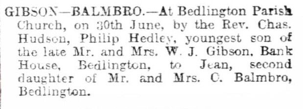
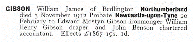
It's been a while but I have managed to do a fair bit of research between dahlias and geraniums. I'd like to get this finished before I fly off to the sun and return to piles of autumn leaves and snow. I've managed to get all my notes written up this week so here's the result. It'll probably need a few posts. Now, where did I leave off? Henry Gibson, head of the family, had died in 1902 at an age of 80 years. His son, Phillip Hedley Gibson – widowed and with no heirs – had followed him to the grave in 1906 leaving his brother, William James, to shoulder the responsibility of running the business. William James was then living in Vulcan Place with his wife Sarah (nee Mostyn) and their children: Mary, Edward Mostyn, William Henry, Lilian, James and Philip Hedley. However, by 1911 he and his family have moved back to Bank House on Front Street East. It has presumably been inherited after Philip’s death in 1906. There are, however, some notable changes in the family in 1911. William James Gibson is still in business as an “Ironmonger & Bank manager” and the property on front street is now described by the enumerator as being a “house and shop”. William James is also widowed but I haven’t been able to ascertain exactly where or when Sarah died. There is a death for a Sarah Gibson, 57 years old, registered in the first quarter of 1911 at Morpeth registry office – just prior to the census being done on April 2nd 1911. On that date three nieces of Sarah (daughters of Sarah’s two sisters), are shown on the census form as being at Bank House. Could they have been there because of Sarah’s death? Unfortunately, Sarah’s death has not been the only grief suffered by the family. In 1908 daughter Lilian had died aged 21 years, at which point, according to the newspaper obituary, her mother Sarah still lived and the family address is given as “North Eastern Bank” ie. Bank House. The only remaining daughter in 1911, Mary 28 years old, is still single and living at home, most likely taking care of the household now that her mother is gone. Also at home at Bank House are sons Edward Mostyn Gibson 27, William Henry Gibson 25, James Gibson 20 and Philip Hedley Gibson 19. The four sons were soon to be left fatherless, however, when William James Gibson dies November 3rd 1912 aged 57 years. He is sadly followed by son James, then 26 years old, in 1917. Those effects are worth approx. £275,450 today, so he didn’t do too badly either. Of the remaining three sons, only Edward Mostyn- and Philip Hedley Gibson have followed their father into the ironmongery business. The eldest, Edward Mostyn, is an ironmonger and also a bank clerk, while brother Philip Hedley concentrates solely on a career in ironmongering. At the age of 19 he is still learning the ropes as an apprentice shop-keeper, presumably in the family shop at Bank House but more about them later. Brother, William Henry, doesn’t appear to follow in the family trade choosing instead to follow his career in the drapery business. In 1911, now aged 25, he has completed his apprenticeship and is working as a draper’s shop assistant. The girl he will marry two years later in 1913, 23-year-old drapery colleague Alice Harbottle Balmbro, is also recorded as a visitor to Bank House in 1911. So, is this the end of an era for the Gibson Brothers Ironmongery business? Now, with their father dead and William H engaged in the drapery trade, only Edward Mostyn and Phillip Hedley remain to carry on the work started 88 years earlier by Phillip Gibson in 1814 – but will they do so?
- 20 replies
-
- 1
-
-
- furnace
- vulcan place
- (and 2 more)
-
What a great idea! Pity I don't live nearer.
-
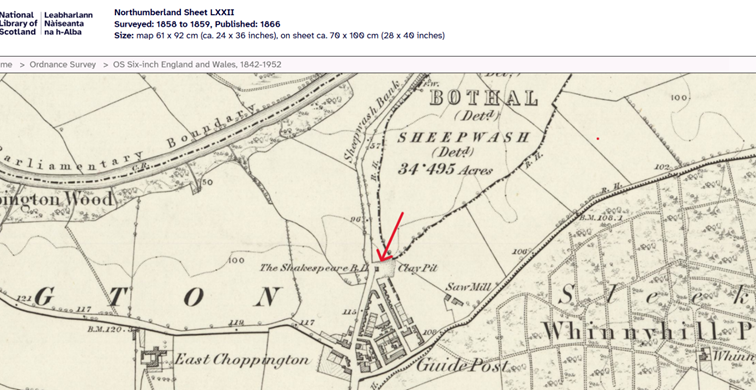
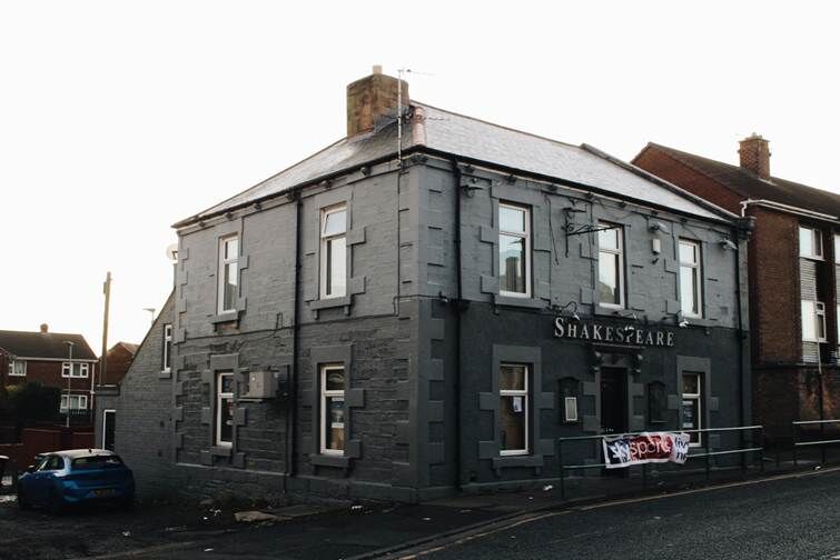
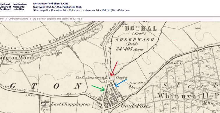
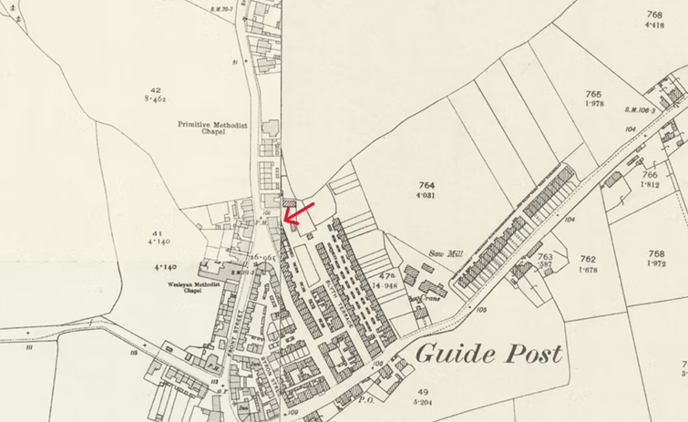
Hi @loopylou Your turn to make a cuppa! Have you ever heard the saying ‘Cherchez l femme’ (literally, ‘look for the woman,) commonly used in detective fiction when solving mysteries? I have my own version ‘cherchez la pub’ (literally, ‘look for the public house’) which I use in detective reality to solve the mysteries of family-whereabouts. While streets and roads often change their names public houses very rarely do and when it does happen, it’s often to a spin-off from the old name. If your relative is John Storey (wife A, children: S A, E and J I) then it’s possible not only to find the street but possibly even the house. Just follow the enumerator on his route until you find both your relative and the nearest pub. Often the pub is still in existence today. Using my ‘cherchez la pub’ method, I followed the route of the enumerator, Mr George Thornton, in the 1871 census: Parliamentary Borough of Morpeth – Parish of Bedlington – Ecclesiastical district of Choppington, Enumeration district 10. George Thornton, describes his enumeration district as “Guide Post East, West, North & South. Choppington, Choppington New Colliery, Bothal Haugh, Sheepwash Bank, Sheepwash & Cleesewell Hill, Stakeford Gate & Cottage in the wood”. Following the census on the 3rd of April 1871 he starts his rounds at the Angler’s Arms (schedule nr 1) at the bottom of Sheepwash Bank and continues up the bank along what is today the A1068 to schedule numbers 2 – 5. These 4 dwellings, simply have the address “Sheepwash Bank” which is located in the “Hamlet of Sheepwash Bank”. From there he proceeds straight ahead to the “Village of Guide Post” where the 7 families resident at schedule numbers 6 - 12 simply have the address “Guide Post”. Still in the “Village of Guide Post” he continues along “Sheepwash West Street” and visits the 16 families living there (schedule nrs. 16 – 28). Moving on, he enters “Sheepwash - East Row” (schedule nrs. 29 – 57) and its 29 families. At schedule nr. 36 I find Thomas Marsden – hopefully the same person you mentioned in your previous post. At schedule nr 45 I find, what I believe to be your relatives, John Storey and family, and low and behold at schedule nr. 54 I find the first public house on George’s round. It’s called The Shakespeare– and here it is on a map from 1866! You’ll see that The Shakespeare is marked BH. This is because it was originally (1850s) a Beer House (marked BH on OS maps rather than PH, Public House). At that time, according to the North East Heritage Library, it was the most northern building in the Village of Guide Post. Being a beer house meant that it was only allowed to sell ale whereas a public house could sell anything. Because of this restriction it was much cheaper to obtain a licence for a beer house. Here is the ‘Shakespeare’ today. If you live in the area you’ll probably recognize it as being on Front Street in Guide Post though this is not the original building. So, where did John Storey live? Between John Storeys residence and The Shakespeare there were only 8 dwellings so my guess is that “Sheepwash West Street’ and “Sheepwash East Row,” both in the village of Guide Post” are the following - in which case John lived towards the northern end of “Sheepwash East Row” (possible West Street arrowed green, possible East Row arrowed blue) just a stone’s throw from the beer house. However, there is another option. East Row probably changed its name and if the above blue-arrowed row is East Row, then it was built out between 1866 and the 1890s filling the gap between the northern end of “Sheepwash East Row” and The Shakespeare. You can see this development in this compilation of 2 maps from the 1890s on the left and the 1920s on the right (The Shakespeare marked in red on the 1890s side and now a PH). If this development occurred between 1866 and 1871 when the census was completed, he would have lived in the new development. What about Thomas Marsden? A possible explanation for Guide Post vs. Scotland Gate may be a district boundary change. Just a thought! I hope this was of use to you and that you yourself might find a use for my ‘cherchez la pub’ method. If you want any of the documentation I've researched give me a shout.
-
.thumb.jpg.7493ddab4a696108cf2b849323d3c155.jpg)
Burial of Annie Margaret Nichol January 1892 at Cambois
Canny lass replied to Colin Nichol's topic in History Hollow
@Colin Nichol Make yourself a cuppa. This may be long! I think, Colin, that you probably made ‘a couple’ of mistakes. Haven’t we all! When we research our family history, we usually start with those nearest in line and work backwards in time: parents, grandparents, great grandparents etc. At that stage, it’s fair to assume that we are beginners in the field of genealogy. Some of the most common mistakes I’ve come across in my 15 years of researching almost every week are the following: 1 Taking for granted that other people’s trees are correct. We look at other people’s family trees and take for granted that they are correct. OFTEN THEY ARE NOT!! Believe me, I’ve been their myself. Always check the information before adding it to your own family tree. By doing this check you will save yourself hours of work later in your research AND you will save other beginners from making mistakes when they look at your tree. 2 Confusing ‘date of birth’ with ‘date of registration of a birth’. A correct date of birth is only found on a birth certificate. The birth index gives the date on which the birth was registered. This can occur several months after a birth for several reasons. This is especially confusing when a birth occurs at the end of one year and is registered at the beginning of the following year. If you want to be certain, obtain a birth certificate copy. 3 Confusing the place of birth with the place of registration. An accurate place of birth is only found on a birth certificate. The birth index gives only the place of registration. Since 1834 England and Wales share a joint birth, marriage, death (and census register). England has 60 County Registration Districts, Wales has 21. (The same registration districts are used to compile the census since 1851) Each County Registration District covers several civil registration districts so called ‘sub-districts’. Some small changes have occurred over the years as parish and county boundaries have changed. Particularly interesting for us Bedlingtonians is the Northumberland County Registration District – and here’s something that may be of interest to you Colin – the ancient county of Northumberland 1834 – 1889 included the town of Berwick on Tweed. Registration districts could even cross boundaries. The Northumberland district has 18 sub-registration districts. One of these which might interest you, Colin, is the sub-district of ‘Bellingham’. You mentioned this a place of birth for Mary Alice but it is (unless you’ve seen a birth certificate) the name of the registration district in which her birth was registered. Each sub-registration district was made up of a number of parishes (which is why the parish name appears at the top of census records). Again, maybe of interest to you, the registration district of Bellingham had 38 parishes one of which was ‘Plashetts and Tynehead’. The registration district of Bellingham was abolished in 1936 and most sub-districts were then incorporated into the Northumberland West Registration District. 4 Getting hung up on names. Names can vary for one and the same person, from census to census. Parents filling in the census forms, more often than not, write the name they use for the child at home (often a diminutive or just one of their two registered forenames). The only accurate name of a child (or wife) is the name that appears in the birth register or birth certificate. So, Winifred Ellen Smith may be written as: Winifred Ellen, Winifred, Ellen, Winnie Ellen, just plain old Winnie or even Nelly. (Those examples all relate to a member of my family). And finally, you’ll be pleased to hear, we should always remember that the enumerator who conducted the local census inquiry was, like the rest of us, only human. He could – and did – make mistakes when transcribing the content of your relatives (often almost illegible) form to his book, the one that is available to us. Do you recognise yourself in any of those beginner’s errors, Colin? Have another look at all the documents I messaged to you. Pay particular attention to children’s names, order of birth, ages and place of birth (not always exactly the same but most within the same registration district (Falstone – 1881 census - is just 4 miles south east of Plashetts). The one exception is ‘Scotland’. That could be explained by an enumerator’s error/ignorance or the fact that the exact location of the England/Scotland border was long a subject of dispute. Just a thought! I personally don’t think that Mary Alice Snowdon was born in Canonbie Scotland. That person is named only Mary in the birth index. She, according to the Scottish Births and Baptisms records, was born 01 Aug 1869. You have confirmed to me that I have located the correct Mary Alice Snowdon (married name Nichol) in the 1911 census where she gives her age as 42 years. In the 1921 census people were required to give their age in years and months which makes it easier to calculate a birthday. The 1921 census took place 19/20th June. Looking at Mary Alice’s entry, her age is given as 52 years and 6 months. From that, I calculate that she was born in December 1868. Her birth wasn’t registered until a couple of weeks later when 1869 had already been ushered in. Sorry, it's a lot to take in, I know. Let me know how you get on. -
Burial of Annie Margaret Nichol January 1892 at Cambois
Canny lass replied to Colin Nichol's topic in History Hollow
Back to the drawing board then!! -
Burial of Annie Margaret Nichol January 1892 at Cambois
Canny lass replied to Colin Nichol's topic in History Hollow
Hi @Colin Nichol. In reply to your message: when searching for a child death without knowing the name it's always worth looking up the child's grandparents. The Victorians were usually quite consistent in naming their offspring: 1st son named after his maternal grandfather 1st daughter named after her paternal grandmother 2nd son named after his paternal grandfather 2nd daughter named after her maternal grandmother Thereafter came parents names and important relatives. Towards the end of the Victorian era the order of naming wasn't any longer so strictly followed but the practice of using the names of just those relatives lived on into the early 20th century. Ann Margaret seems to have been a name worth preserving among the Snowdons. James and Mary Alice's first child, Annie Margaret was given her maternal grandmother's name. That maternal grandmother had also given her first daughter that name. (that child also died before the age of 15). The name was then 'vacant' for future children therefore I searched for it in the birth index during the years between the births of George and James where the time-span allowed for a pregnancy. Of course, you would need to obtain a birth certificate to verify that James and Mary Alice are the parents but I think the chances are good. Hope this explains the need for the census documents. -
Burial of Annie Margaret Nichol January 1892 at Cambois
Canny lass replied to Colin Nichol's topic in History Hollow
Hi @loopylou, could you check the year of that obituary for me (my BNA is down for maintainence at the minute). The death record that I found was 1892. If it was 1893 then it throws my research of balance a bit. Thanks in advance. -
Burial of Annie Margaret Nichol January 1892 at Cambois
Canny lass replied to Colin Nichol's topic in History Hollow
Pleased to have been of help. I think I may have found the other child who died between 1901 and 1911. I believe that James and Mary Alice had another daughter born in the first quarter of 1897. That would fit in nicely with the gap between the births of George and James. There are no other gaps which would allow for a pregnancy between 1901 and 1911. The firstborn daughter, Annie Margaret Nichol born 1891, was given her maternal grandmother’s name and her birth was registered as Annie Margaret. What I believe to be the second daughter, born 1897, was also given her maternal grandmother’s name but without the diminutive form. Her birth was registered as Ann Margaret Nichol. She died the following year and her death was registered in March 1898 but then using the name Annie Margaret Nichol. She was also buried in Cambois. That parents ‘recycled’ names isn’t uncommon, especially if it was the name of a grandparent or parent. I myself am a perfect example. My mother gave birth to a daughter in 1931 and gave that daughter her maternal grandmother’s name – Annie. The child, Annie, lived only a few months. I was born in 1947 and was also given my maternal grandmother’s name though without the diminutive form – Ann. Like you, I never knew anything about Annie (or another brother dead before my birth) until I was in my 70s. They were never mentioned. The discovery of a sister named Annie explained something that had puzzled me for years. My mother always called me Ann. Everybody else called me Annie. My mother had one Annie and one Ann and for a mother the one could never replace the other. If you would like the birth, death and burial indexes for Ann Margaret born 1897 let me know and I’ll post them to your in-box (the envelope in the top tight-hand corner of the screen). -
Burial of Annie Margaret Nichol January 1892 at Cambois
Canny lass replied to Colin Nichol's topic in History Hollow
Hi again @Colin Nichol. The 1911 census form filled in by James himself gives the information related to the length of the marriage and the number of children living and dead. I also would assume that St Peters is the burial place of Annie Margaret. However, money was tight in those days so she may be buried in another person's grave as she was so young. It was common practice for an infant to be placed inside the coffin of the next adult to be buried.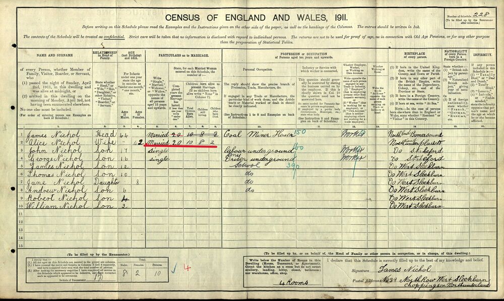
-
Burial of Annie Margaret Nichol January 1892 at Cambois
Canny lass replied to Colin Nichol's topic in History Hollow
Hi @Colin Nichol Welcome to the forum. The parish of Cambois was originally part of St Cuthbert's, Bedlington, it was a small parish served by the vicar of Sleekburn and a non-stipendiary priest. The Cambois church, St Andrews, is a small church built in 1860. It was formerly the mission church of St Peter's Church, West Sleekburn until it closed in the 1990s. As a mission church it did not have a graveyard so burials took place at St Peter's, West Sleekburn. Cambois, St Peter: Records of baptisms 1865-1936, marriages 1866-1998 and burials 1874-1966 are available at Northumberland Archives Service. P.S.Did you know that James and Mary Alice lost a second child within the first 10 years of their marriage?

-
Hub German Pork Butcher, Bedlington 1901-11
Canny lass replied to Richard Norton's topic in Friends and Family
Hi @BMog Sorry, I don't know what happened above. It just wouldn't let me write or delete anything! Mary's marriage was registered in Durham registration district which includes the city of Durham. This doesn't necessarily mean that she lived - or was married - in the parish of Durham. The Durham registration district had, in 1904 when she married, at least 37 different parishes. Couples usually married in the bride's parish so what you need is a copy of the marriage certificate which you can obtain from the GRO. Many certificates are now digitalized and can be bought as a pdf file - much cheaper than the paper copies. The certificate will give you the address of both Mary and Henry as well the parish in which they married. That will give yo more information to work while trying to find his employer - or place of business if he was self employed. If the latter is correct then you can try the directories and gazettes. Hope this helps. Good luck with your research. -
Hub German Pork Butcher, Bedlington 1901-11
Canny lass replied to Richard Norton's topic in Friends and Family
@BMog -
1968 is a bit late for me as I left in 1962. However I do recognise the odd name. John Aynsley, Netherton lad, a bit younger than me, contributes on Bygone Bedlington I believe. Good luck with your search Malcolm that could be quite a reunion!
-
Sounds as though they've hired 'the Donald'!
-
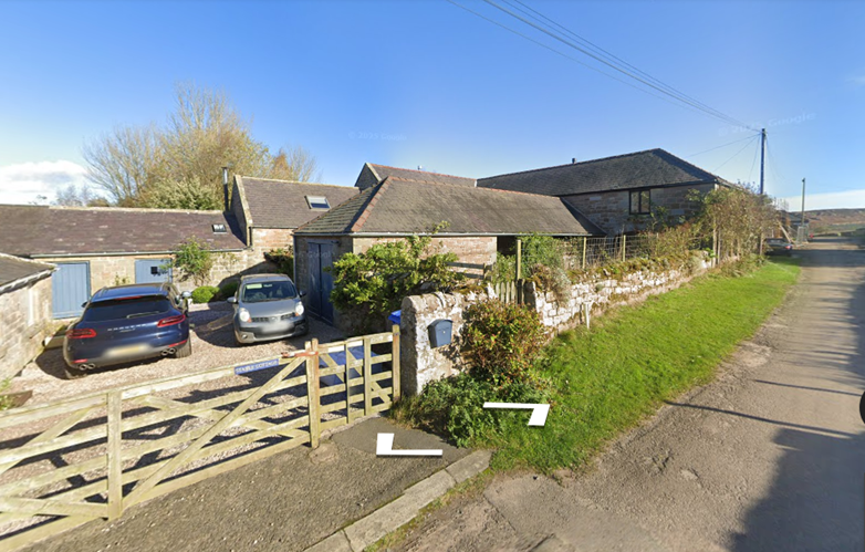
Your great grandfather, James Scott, also worked as an agricultural labourer. In 1901 when Ralph gives his occupation as Farmer/butcher, James is working with his brothers on the farm as a labourer. In 1903 he is still in the area, presumably working at Westfield, when he marries. His children are born: Ralph at Springhill, just a stone's throw away from North Sunderland, Mary Jane is, in fact, born at Westfield and Henry at Elford - also a stone's throw away from North Sunderland. It's not clear if James was living at Westfield or elsewhere. The children may have been born at the homes of Mary Jane's relatives which was quite a common occurance. Mary Jane, your great grandmother, was from Norham, which is also on the map just south west of Berwick so she was a local lass. By 1911 James and his family have made the move from North Sunderland to Holborn about 11 miles south of Berwick on Tweed. It is here he becomes a farmer, working for himself at West Holborn. Lowick Beal. Address: Farm House, Holborn West. (See https://historicengland.org.uk/listing/the-list/list-entry/1156167 for map and better photo or ‘drive’ past on Google maps as I did). The farm is now a grade 2 listed building. If you’d like any of the documentation from which I’ve taken this info leave your e- post address in my mail box (move your marker over my ‘hat’ and choose ‘message’. It’s not wise to leave it here on site.
-
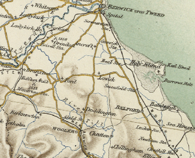
@Susan J-D Hi again! This may be long! I don’t know how well you know the area so I’ll start with a map which covers most of the places I’ll mention: Berwick, Seahouses, Bamburgh, Wooler, Lowick, Belford and Chathill. North Sunderland isn’t shown but it’s almost part of Seahouses. It’s not a huge area as you see. Your great grandfather James and his father, Ralph, didn’t jointly have a farm. They had 2 quite separate places and I can’t say if they owned or rented them. Ralph, who would be your 2x great grandfather, was an agricultural labourer at the age of 19 living with his widowed mother in New Bewick near Wooler. 10 years later, in 1871, he is married and living in the small village of North Sunderland, adjacent to Seahouses on the north east coast and is a butcher. He seems to live here for many years with the same neighbours and his children are all born here. In 1891 he gives his occupation as “Butcher & farmer” and he is now self-employed, so he has presumably taken over a farm – rented or bought. He employs his sons: George as his butcher’s assistant and Ralph jr – 13 years old - as a shepherd. Just where the farm is located isn’t clear from the documentation available other than that it is in North Sunderland, In 1911 the farm address is given as “Westfield, Chathill”, which is about 9 miles north of Alnwick and 3 miles inland from the North Sea coast between Seahouses and Bamburgh. I think it’s fair to presume that it is still the same farm. He now gives his occupation as “Farmer”only so he seems to have given up butchering – possibly to his son George. His sons, Ralph jr, & John, and daughter Annie work for him. As Annie is a dairy maid it may be a dairy farm. Ralph dies in 1913 and I can see that his son, Ralph jr. seems to take over the farm. In 1921 he is still single and running the farm together with his unmarried sister, Annie, as housekeeper. Today, Westfield is a B & B guest house.
-
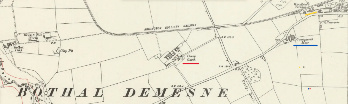
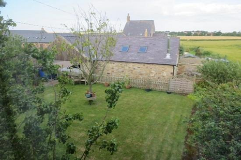
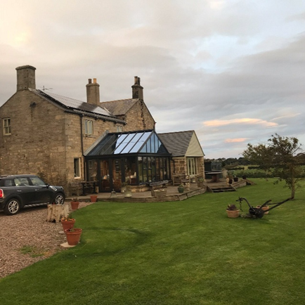
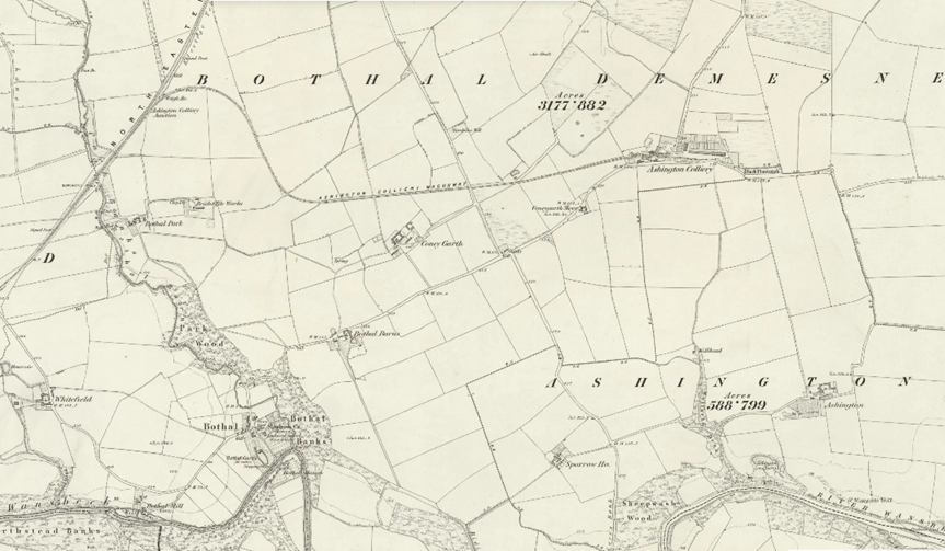
Hi again @Susan J-D. It’s been a cold, wet weekend here which gave me time to have another look at your question. I still think that Coney Garth may be the home farm for Bothal Castle – which was originally the manor house before being granted the rights to call itself a castle. As a manor house under the feudal system, it would certainly have a home farm. As I said before, the home farm was usually close to the manor house and that would certainly make Coney Garth a respectable contender. However, I have to admit that I have been assuming that Coney Garth (marked red on the map) and Coneygarth Moor Farm (marked blue on the map) were the same thing. A more thorough rummage through the old maps has shown me that this was not the case. Coney Garth has been named on maps since at least 1805 and, while the small cluster of buildings to its east have appeared an equally long time, it is not until 1921 that the name Coneygarth Moor appears. Your great grandfather, James Scott, seems (according to the births of his sons James and Thomas John) to have moved the 40 or so miles from Lowick to Ashington at some point roughly between 1914 and 1921. Just where he moved to is difficult to say but certainly in 1921 he was living and working at Coneygarth Moor Farm in the Bothal Demesne and he was still there in 1939. He did not own the farm though, as you say, he was a farm owner prior to his move to Ashington – as was his father before him. James was, in 1921, a farm steward - a very respectable position - employed by the Ashington Coal Company who owned the farm – as well as the remaining seven largest farms in the area. All 8 farms were run by one farm manager; George Preston Graham, and he lived in one of the large houses on Woodbine Terrace (marked yellow on the map) just a stone’s throw from your great grandfather. At that time Ashington Coal Company was owned by the Portland family who lived at Bothal Castle (which is still owned and occupied by their descendants), so indirectly James was employed by the lord of the manor – the Duke of Portland. He, and his Ashington Coal Company, seem to have been good employers. They built many houses for workers in both the mines and on the farms and one purpose of the farms was, in fact, to supply food for the workers. They had a milk ration of 2 quarts a day and even the farm cats had a ration of 1 pint a day! If you have seen your great grandfather’s address given as “Home Farm” on any document then Home Farm would seem to be Coneygarth Moor Farm rather than Coney Garth. I find it surprising that Coneygarth Moor farm should be the home farm as it is considerably less in size than Coney Garth – which, having had a good look around the maps, seems to be by far the largest in the area as well as being located nearest to the manor house. Let us know how you get on at the Northumberland Archives!

-
@Susan J-D Have you considered that Home Farm and Coney Garth may be one and the same thing? The name “Home Farm” is traditionally used to refer to any farm that is part of the manor house’s demesne – often the farm lying closest to the manor house. These were often farmed by a farm manager, hired by the lord of the manor, to cater for the needs of his household while other land was rented out to tenant farmers. Looking at this map from 1859 you can see that Coney Garth (centre), located between Ashington and Pegswood, is a considerable size and just a stone’s throw from Bothal Castle (bottom left) and also part of the Bothal Demesne. Of course, your relative may not have worked for the lord of the manor. Much depends upon when your relatives lived there. The name Home Farm can live on for centuries after being used as such.
-
That is horrendous, Malcolm!! What is politics coming to? It sounds as if we are in America, but we are in Bedlington! It just makes no sense at all.
-
It's confirmed on NCC's website. Well done Malcolm! https://beta.northumberland.gov.uk/elections/2025-county-council-election-results-summary
-
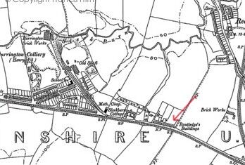
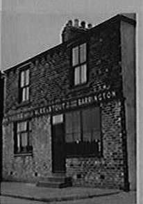
I know very little about the content of the photo I posted above. I inherited it, and a lot of other material, many years ago from a former colleague and fellow researcher. Today I did a quick bit of research on Routledge’s Buildings. They may well have been several buildings – if the number of families living in them is anything to go by. In 1881 there were 25 families living in Routledge’s Buildings, Barrington. Nothing is known of the size of the individual family’s accommodation. One resident is Jane Routledge, a 62 year old widow, living with her two daughters of 20 and 15 years and her two sons, Robert 23 years and John 18 years, all with their roots in Cowpen and Bebside. In 1891 there are 31 families living in Routledge’s Buildings. Most accommodation seems to be of 2 rooms per family though the occasional 3 or 4 room dwelling does appear. John Routledge is still in the same house. In 1901 there are 27 families in Routledge’s Buildings. John Routledge is still there. The number of rooms per family varies from 2 to 5, though mostly 2. All in all, there are 74 rooms accounted for in the census returns for the address. Clearly, that is many more than would possible in the building on the photo. Next step – look at the building on maps! On the following map, dated 1896, I can clearly see that Routledge’s Buildings is infinitely bigger than in the photo. Furthermore, it appears to be built in two blocks. I’d suggest therefore that the photo is only part of Routledge’s buildings.
-
@7RIrF This is the only picture I have of Routledge Buildings. As you see it's not a row or terrace. It's just a 'building'. In my experience most of the addresses including the word "buildings" were exactly that - a building. It's a bit misleading that it's usually in the plural form 'buildings'. As for the name they usually, but not always, take their name from the surname of the owner. If you can yell me just which census you found Routledge Buildings in I can probably help you a bit more. What exactly do you mean by "(Blank) Buildings"?
-
Well! That was a nice little wander around a place I love, and looking so much better than it's ever done before. Thank you Malcolm for all your hard work.