James
-
Posts
213 -
Joined
-
Last visited
-
Days Won
53
Content Type
Forums
Gallery
Events
Shop
News
Audio Archive
Timeline
Posts posted by James
-
-
On 31/01/2021 at 17:31, Alan Edgar (Eggy1948) said:
@James - do you have a book with that info in or is it online?
I was thinking of creating an Album - 'Doctor Pit and Rows' - where any member could add new entry and info.
In the 1980’s Stephen Martin wrote 7 booklets that together formed the “Bedlington Villages History Series” The titles are – Bedlington, Sleekburn, Stakeford & Bomarsund, West Sleekburn, Choppington, Barrington, Netherton. (Perhaps there is also one on Cambois?) Unfortunately I only have 3 of them – Bedlington, Netherton and “Bomarsund & Stakeford”
I think it is a good idea to open an album on the Doctor Pit and Rows. There have been lots of photos posted in the history forum over the years and it would great to see them in an album. I have quite a few so as soon as the album is open I will post them.
-
 1
1
-
-
On 27/01/2021 at 20:49, Rigger said:
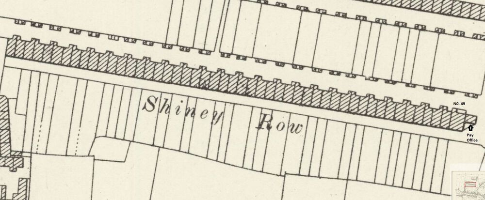
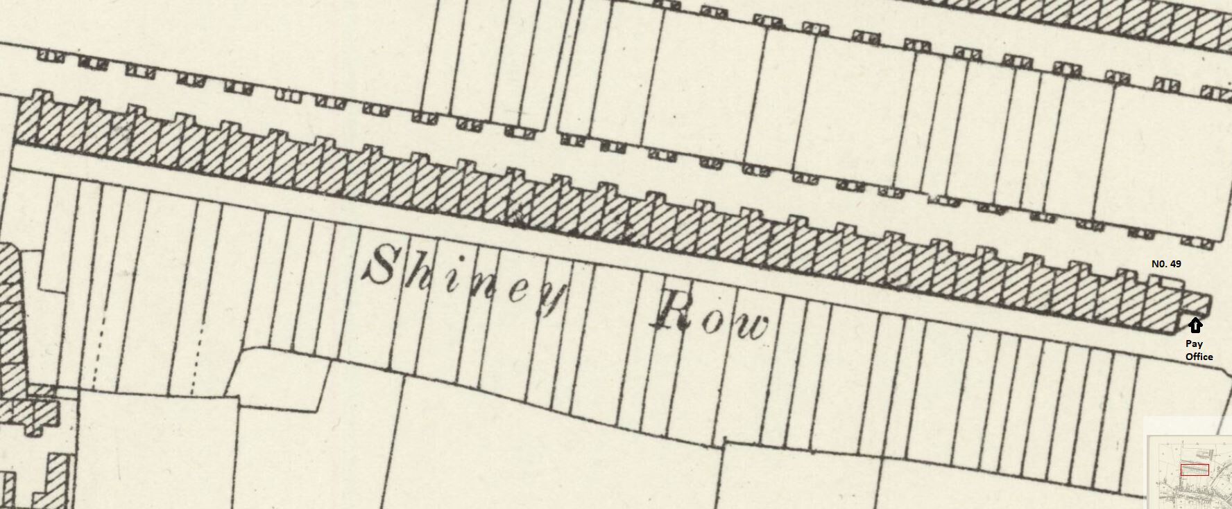
I have been informed Shiney Row was built by the Bedlington Coal Company about 1870. Have looked in the 1871 Census but can find no evidence people living there at that time. Does anyone know when they were first occupied? Also, can anyone advice where I can get a plan or drawing of one of the houses in Shiney Row which all had 3 bedrooms and a kitchen except number 49 which had 4 bedrooms and a kitchen. Thanks, Any help appreciated.
Probably the building work was not completed until after the 1871 census. Number 49 was bigger than the others because it was the undermanager’s house. In the 1911 census, Thomas Croudace, the Dr Pit undermanager was living there. His son, Charlie Croudace was the colliery manager for many years until 1955 when he was succeeded by George Hetherington. The pay office was built onto the gable end of No 49 where I received my first week’s pay of just over £4 in 1957.The building dates and number of houses of all the rows according to Stephen Martin’s book on Bedlington are as follows-
Cross Row. 12 houses built in 1855 to accommodate the shaft sinkers.
Shiney Row – 1870, 49 houses.
Doctor Terrace – 1874, 49 houses.
New South Row – 1886, 24 houses.
Telephone Row – 1886, 20 houses.
North Terrace - 1906, 50 houses.
A total of 204 families.
-
1
-
-
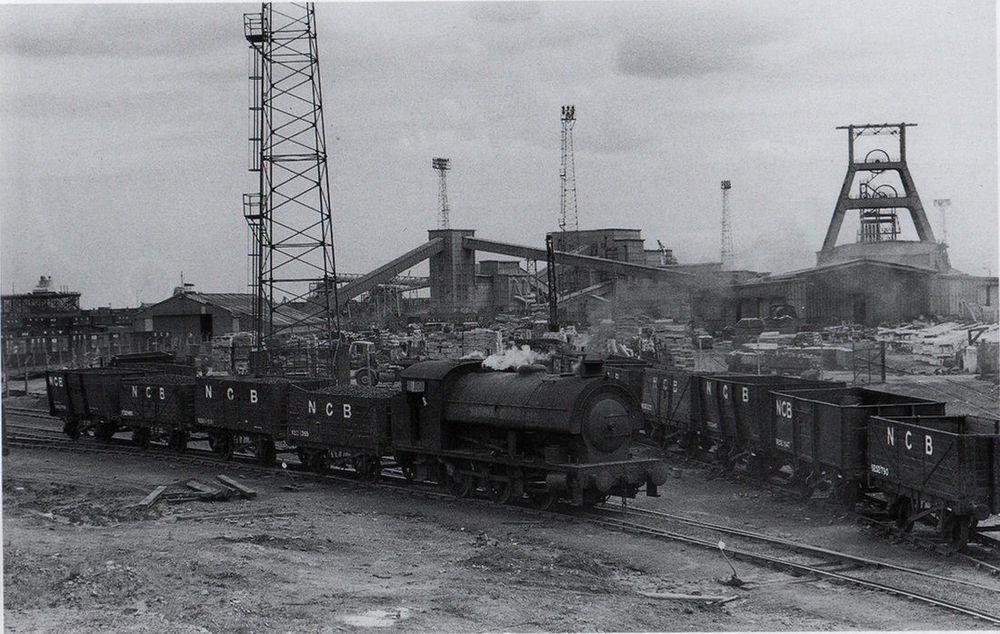
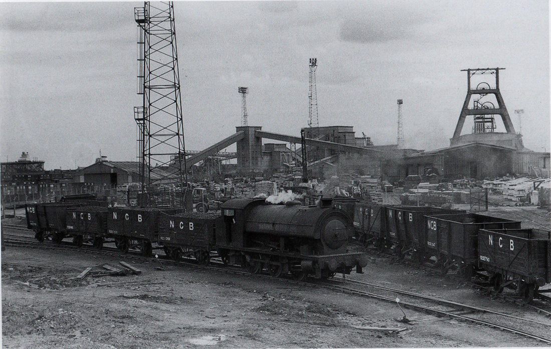
Bates Colliery behind the offices around the wash plant area taken late 1950's
-
1
-
-
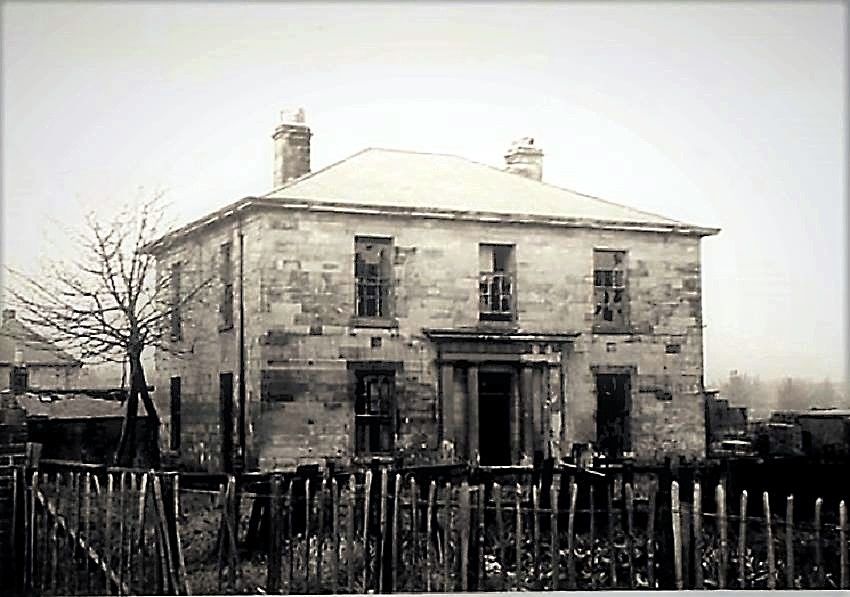
On 03/05/2020 at 12:48, Alan Edgar (Eggy1948) said:
@Canny lass - @Ovalteeny might have download and saved some photos and info of Hollymount Hall from the Bedlington Facebook groups as his family lived there for a couple of years. This is the one photo of Hollymount Hall that I have downloaded.
-
1
-
 1
1
-
-
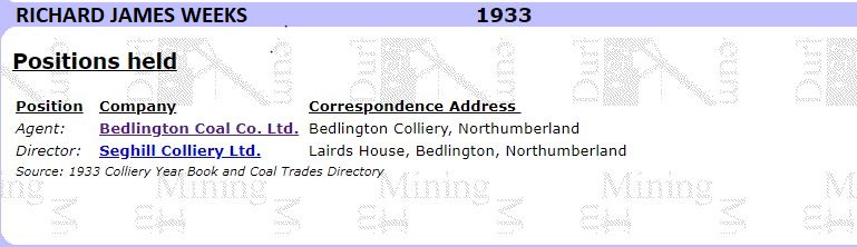
There were two members of the Weeks’ family that lived in Lairds house. The first was John George Weeks, born 1844 and his son Richard James Weeks, born 1884. Each of them held the position of Agent for the Bedlington Coal Company. (Information obtained from one of Evan Martin’s books and the Durham Mining Museum.)
The Bedlington Coal Company transformed Bedlingtonshire and there is no historical reference to the company anywhere that I have seen.
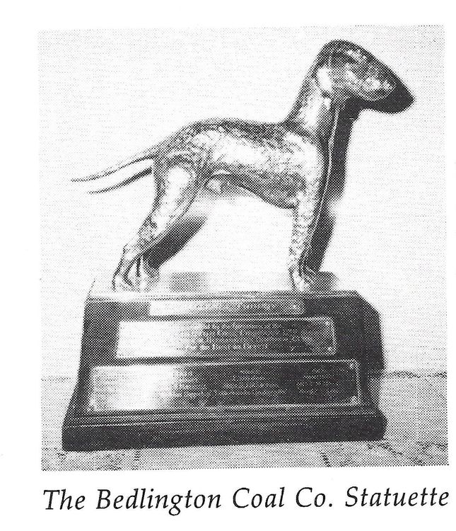
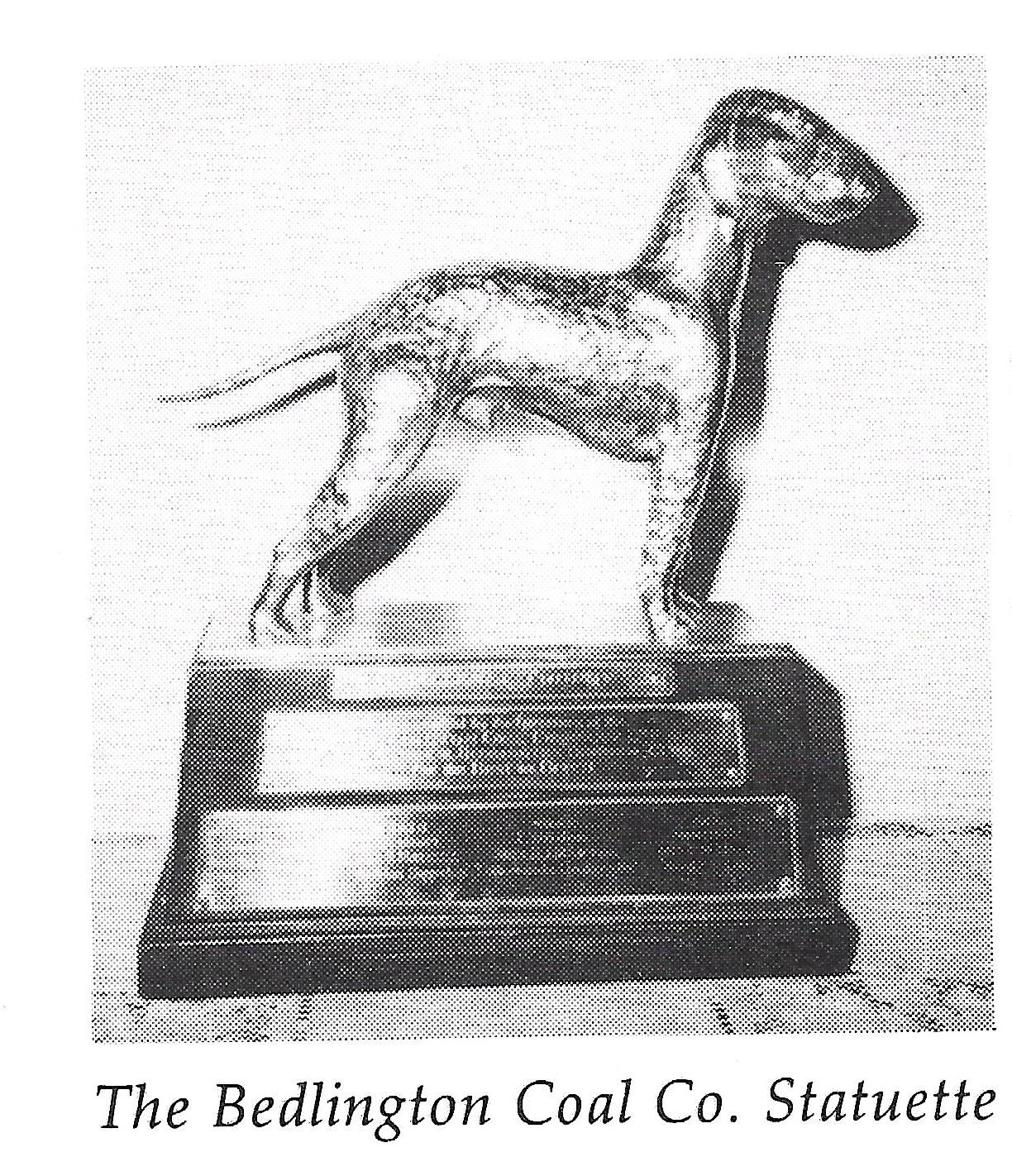
The Bedlington Coal Co. Ltd Challenge Cup, a solid silver model of a Bedlington Terrier was donated to the National Bedlington Terrier by Richard Weeks in 1936 and is still the top trophy presented at their annual Championship Show.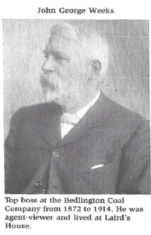
-
1
-
-
Thanks for the information Eggy.
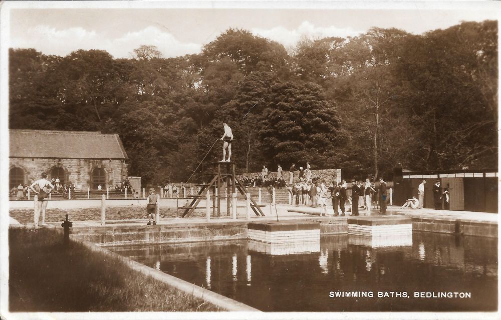
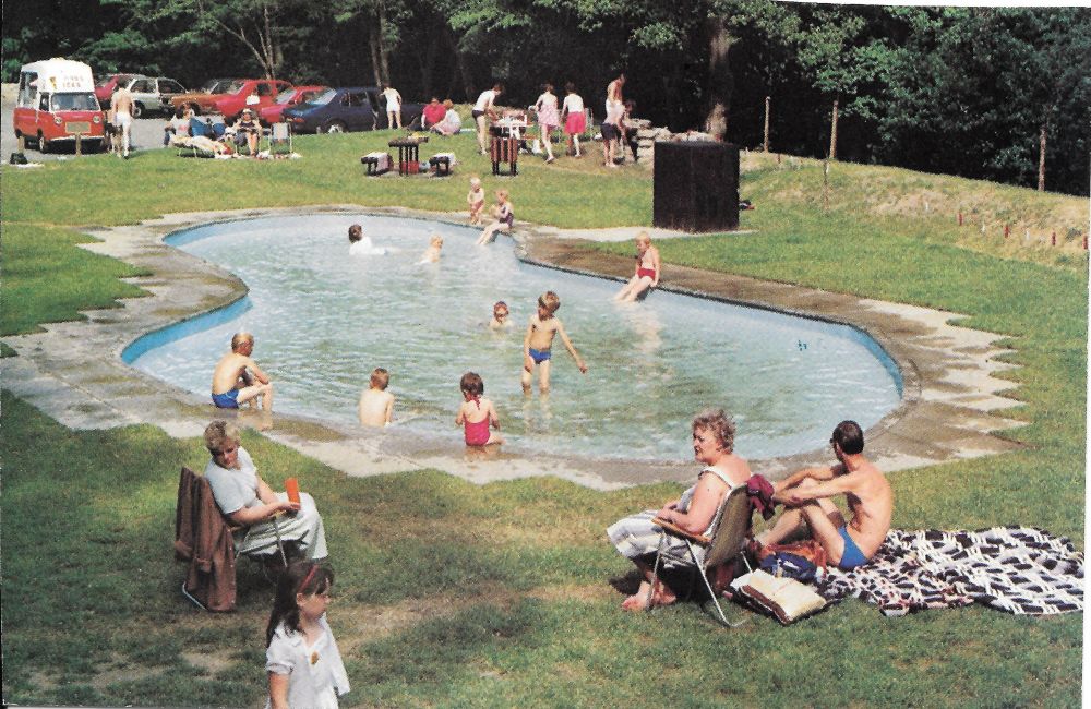
It looks like the swimming baths were open for about 47 years; 1926 to 1973. After it closed it was converted to a paddling pool but this didn't last long and now it is a children's play area. The two photos are taken from roughly the same position about 40 years apart.
-
1
-
-
Bill
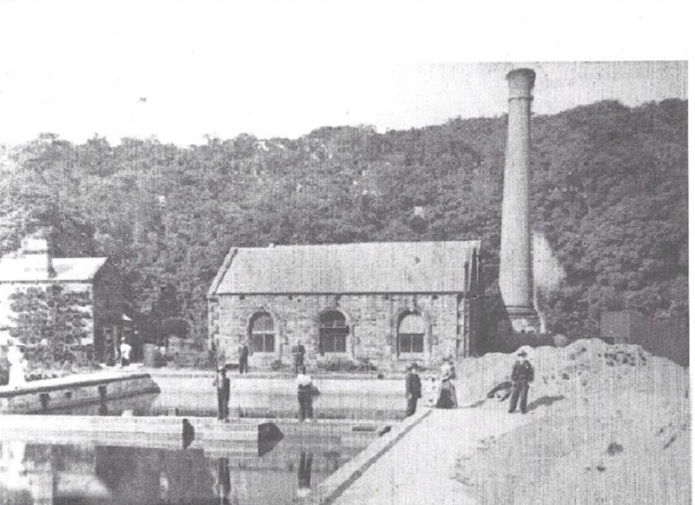
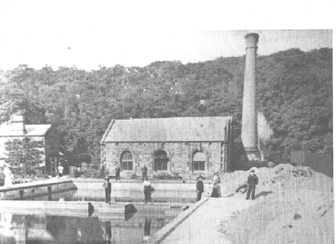
The structure in the photo is a few meters downstream of the dam I mentioned in my previous post. As HPW states they are what are left of the supporting columns for two huge pipe that carried water from the dam down to the waterworks at Humford, located on what is now the car park. If you walk from the dam down to Humford on the Bedlington side of the river, remains of the pipes and the brick supports can still be seen here and there. According to Stephen Martin’s book on Bedlington, the steam driven pump station was commissioned in 1876 and pumped filtered water to the reservoir behind the Red Lion and operated for 50 years. The (empty) reservoir is still there and can be seen from the back entrance to the Red Lion. Before the waterworks, water in Bedlington was obtained from wells and springs. As we know, after the waterworks closed in about 1925 they were changed into an open air swimming pool (Humford Baths) so the pipes from the dam then supplied water to the baths until they closed. Anyone know when the baths were officially opened and when they closed for the last time?
The photo of the waterworks was taken over one hundred years ago.
-
1
-
-
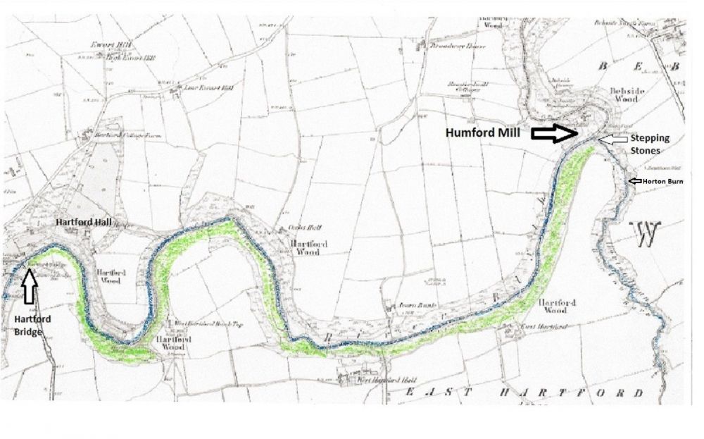
20 hours ago, Bill 19 said:
Hi all.
New member - very interesting and informative thread.
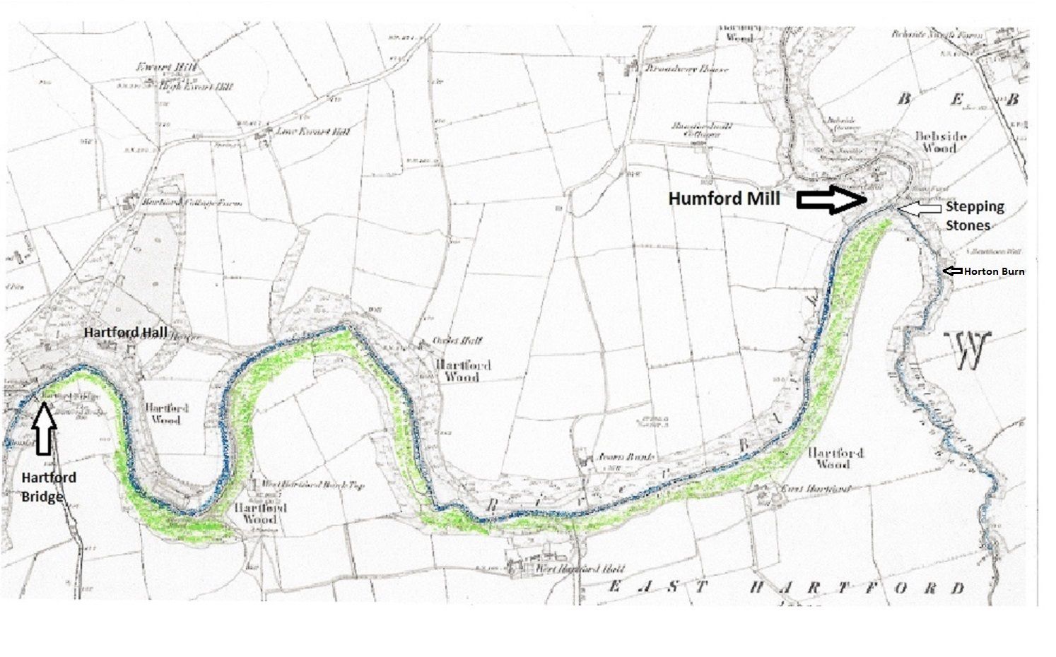
Does anyone know the small fenced-off Coal Board site on the south bank of the river between Humford Mill and Plessey Woods? It’s near the top of the bank, and there’s an entrance door and a half-visible fan of a few feet in diameter. Presumably it’s a ventilation fan and its machinery.
Unfortunately I didn’t have a camera on me when I saw it, but it’s just north of the Hartford part of Cramlington, so would it likely be related to the Hartford (or possibly Plessey) mine?
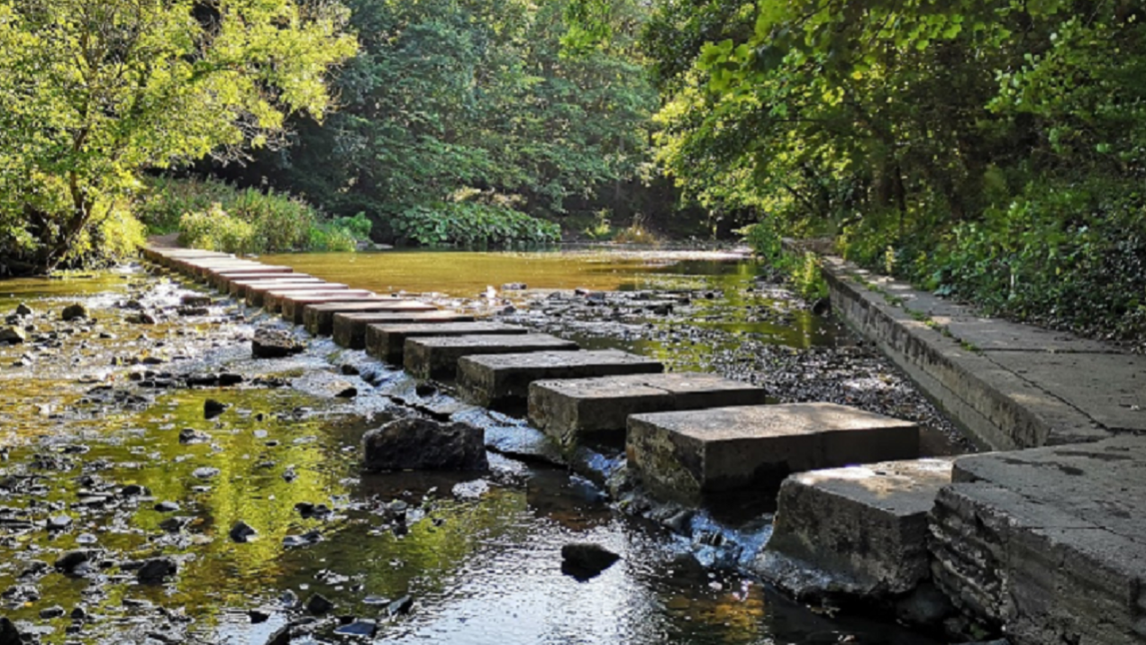
It’s not easily accessible - I came across it while on a walk to see how far the footpath goes on the south bank after the steppingstones at Humford. The path soon becomes blocked by fallen trees, overgrown bushes, etc, and is quite dangerous at a couple of points, with steep muddy drops to the river!
Hi Bill
I know the walk you describe in your post (did it last year) but didn’t see the structure you mention. I have attached a plan with the Hartford Woods shown in green. The footpath leads through these woods.
As you say, to get there, you have to walk over the stepping stones at Humford Mill to the Hartford side of the river, turn right over the wooden footbridge that crosses the Horton Burn and into Hartford woods and follow the (difficult) footpath that leads to Hartford Bridge.
Can you give a rough idea of the location of the structure you saw on your walk?
There are two distinctive features on the walk; first the huge concrete culvert that was built to drain water from Brentford Nylons and the other is the dam that used to supply water to the swimming baths. Is it near any of these two points or at the end of the walk, i.e. the field that leads to Hartford Bridge (opposite Hartford Hall)?
Any other pointers would help, e.g. at the top perimeter of the woods along the fields, or near the river.
Another possibility is that when you state at the “top of the bank”, perhaps you followed the footpath through Horton Dene which is a fairly steep walk along the burn towards Hartford Colliery (East Hartford)

-
1
-
-
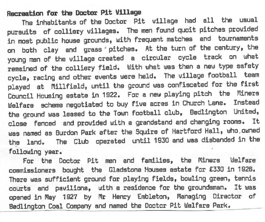
The attached document is taken from Stephan Martin’s book ‘Bedlington”. He seems to be referring to the same football field as you are but he states it was at Millfield. This would make sense as it would have been an ideal spot for a pitch.
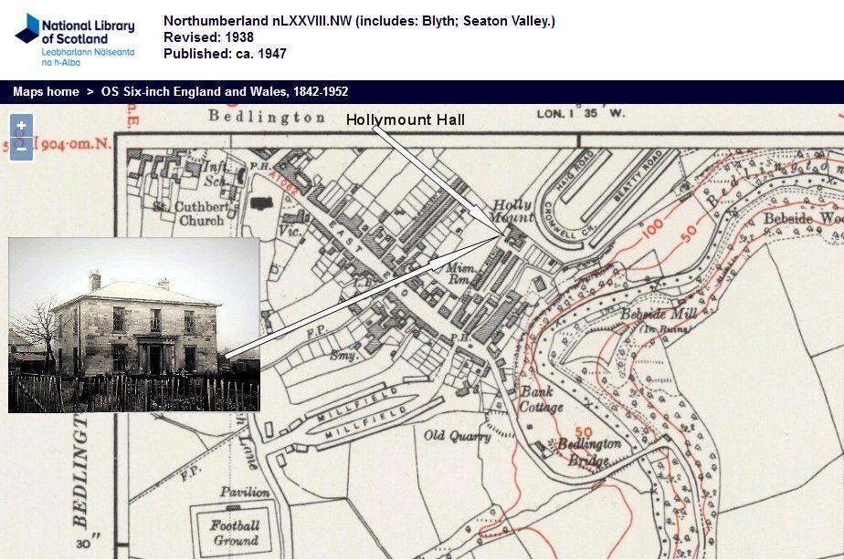
Regarding your question about any building work around Hollymount that could of taken place in the 1920’s, there is a map in an earlier post, showing an open area behind Hollymount Hall. This is where the words Holly Mount are printed on the map. Haig Road, Beatty Road and Cornwall Crescent were built there after WW1 and it is possible that a football field could have been here. This is next to the Bedlington Terriers’ pitch
-
On 06/10/2014 at 18:17, Reedy said:
HPW- re an earlier post, Fred Reed is not related to us.
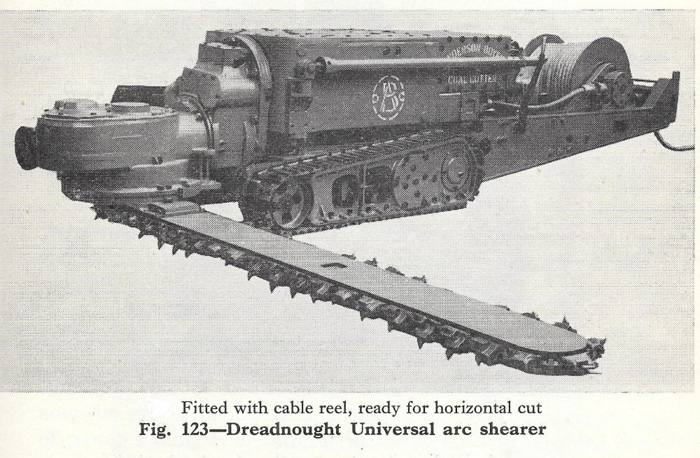
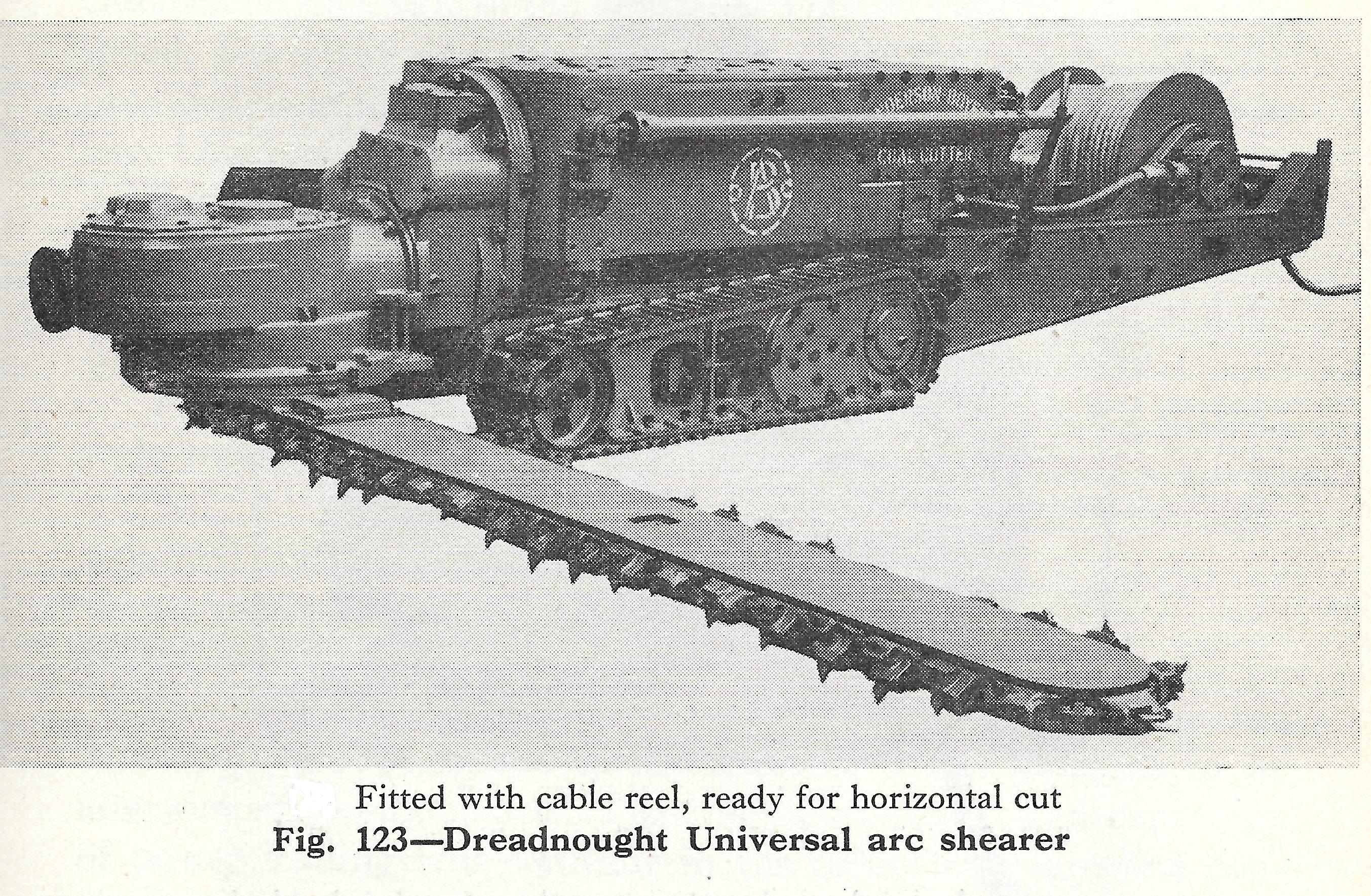
Dads accident- He was repairing an Anderson Boyes Arc Shearer by replacing plates on the clutch as opposed to fitting a new one. The jib and revolving head which were supported on 6inch chocs, came off onto his left leg crushing his foot. Luckily his right foot ended up under the track and was untouched.
One of the men working with him was called Hetherington who may have ended up as an area manager covering several pits.
Reedy – This is a photo of the Anderson Boyes Arc Shearer coal cutter you mention in your post. They were used at the Doctor Pit Drift from about 1948 to 1960, in bord and pillar sections mining the 6 foot thick Main Coal seam. The district was called the ‘West Winnings” and was under what is now the golf course. It was decided that it would be cheaper to mine the Main Coal seam by opencast mining, so in 1960 the “drift” was closed
 .
.
-
On 11/12/2018 at 23:10, HIGH PIT WILMA said:
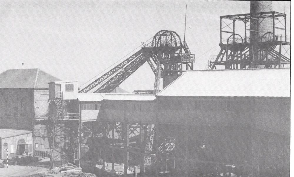
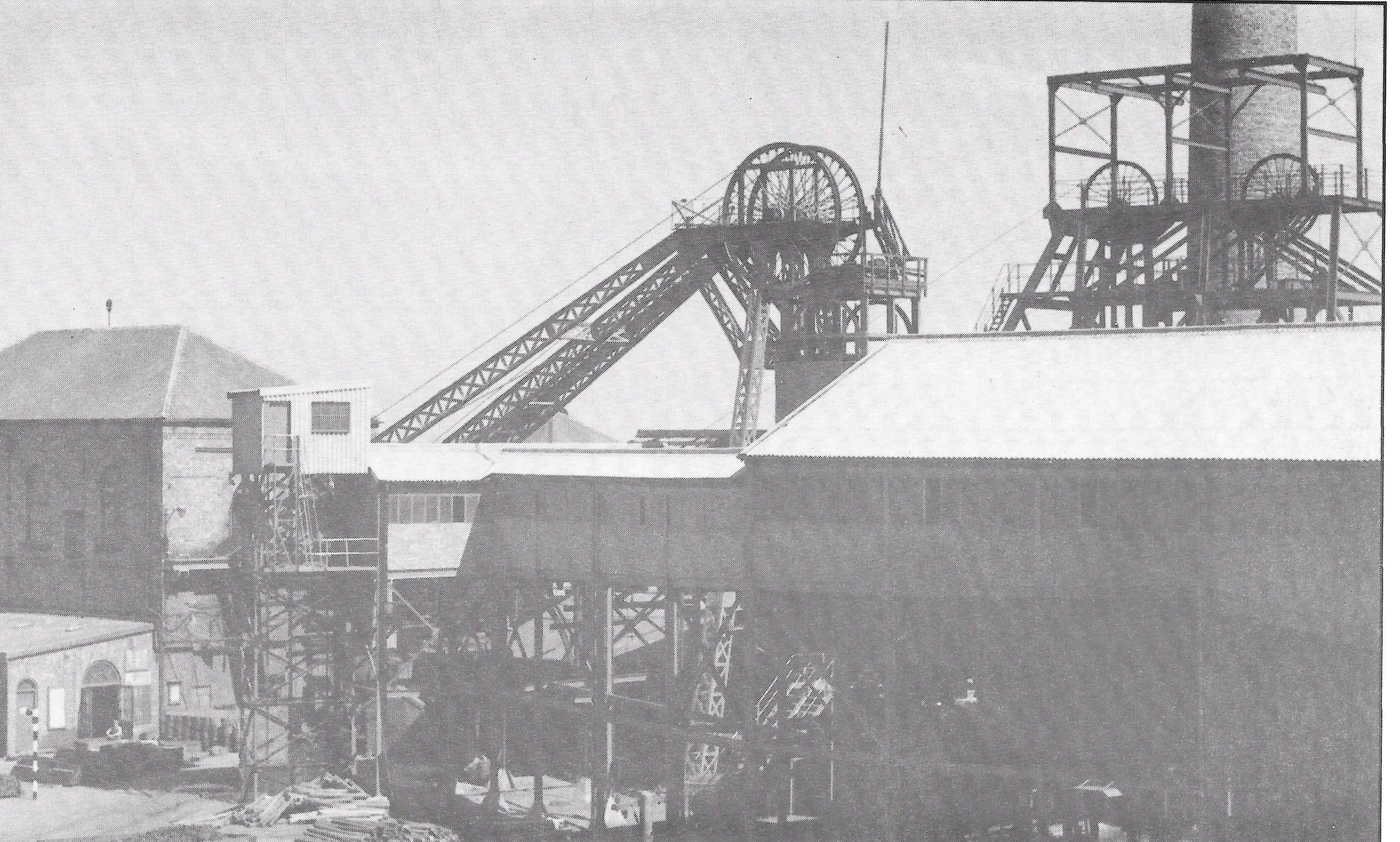
 Your query aboot the Shafts,Alan..!...thi Aad Pit was a weird set-up..The "Smallest" Headgear,[on the left..] was the deepest and widest shaft,cos it ran both cages conventionally in the same shaft.
The shaft was 900 feet deep,and and the lowest seam was the "Harvey",at anything from 1 foot 10 inches high,varying up to 2 feet and 2 inches high.[They drifted down to the "Denton Low Main" seam not long before the Pit closed in 1971.]
A think they worked aboot twenty seams from that shaft,over the 145-or so-years of the Pit's life.
Noo,the "biggest" Headgear ,[on the right] was that size,because each cage had it's own shaft,sunk adjacent to each other,for some wierd reason which aa canna fathom oot![unless Geological conditions meant it had ti be that way.]...this set-up was referred to as "The Little Pit",and the "Harvey" shaft was referred to as .."The Big Pit".
The Little Pit was sunk down to the "Main Coal" seam,when a started,although it might have been down to a deeper level in the old days,and may have had a false "Sump",at the level it was when Aa started.[The Sump was generally at the shaft bottom,below the level where the cage would come to rest,to change tubs,and was a collection point for all of the minewater pumped from all over the pit...Where huge shaft pumps pumped all the water up the shaft and out to what we called.."The Pit Ponds"...settling chambers to allow all the silt to settle out.]
The "Banksmen", on the Heapstead",at the surface,and the "Onsetter's" at the shaft bottom,used ti walk a million miles a day,to load and unload each cage in turn,even though the shafts were only a few yards apart![as opposed to a normal set-up where they would only have to step a few feet from one cage to the other.[daily average..winding aboot 25-30 score of tubs a shift....i.e. 25 x 20 or 30 x 20...one score=20 tubs]
So the two headgears had three shafts between them!
Ye canna see from this angle,but if ye check oot any pics in thi gallery,showing the Headgears fully sideways on,ye wud see hoo the big headgear has the two cage wheels offset,and slung one below the other...and by scaling,ye might can envisage hoo far apart the two shafts were....the average Pit Cage Wheels were aroond 12 feet high...give or take a foot or two!...so ye can judge the size of the headgear...but summick is telling me that them wheels were a bit smaller than average....aa not sure!!
Hope ye dinna mind the lang-winded explanation Alan...ye knaa me!!
Cheers!
I have attached a couple of photos of the headgear from different viewpoints showing the unusual arrangement of the pulley wheels at the “Little Pit’.
In James Tuck’s book “The Collieries of Northumberland”, there is a chapter on “The Auld Pit” and he says this is known as a ‘Tandem Headgear’ and that the only other tandem headgear in Northumberland was at Seaton Delaval colliery. He also mentions that the ‘Little Pit’ had 2 small diameter shafts but until I read your posting I didn’t appreciate that the reason for the tandem configuration was to position the pulleys over two separate shafts situated next to each other - Thanks HPW for your excellent posting.
There must have been a ventilation shaft, so the ‘A’ pit would have had 4 shafts in total.
-
2
-
-
There is an article on the murders in the Northumberland Archive website and it mentions that the weapon used was a Winchester Repeating Sporting gun (not a “rifle”).The doctor’s report states that he saw “pellet marks on the victim’s tunic and on exposure saw many small circular wounds”. This and the other injuries he mentions in his report indicates that the weapon used was a shotgun. Also the police “extracted pellets from the wall and more recovered from the floor”. Pellets are what are fired from a 12 bore cartridge.
In Evan Martin’s book “Some Men, Murders and Mysteries of Old Bedlington” there is a short story on the Sun Inn murders and he states the weapon used was a Winchester shotgun.
-
John Elliot McCutchen’s book “The Hartley Colliery Disaster” refers to John Short and tells us that he was the engine - wright at the colliery and led the first rescue operation. He also gave evidence at the inquest.
-
1
-
-
On 20/01/2018 at 22:18, HIGH PIT WILMA said:
Hi Peter,welcome to the site!I thought the same as you even if you were cracking on!!
It could have been one of many tunnels running from Bedlington main street down to the river,that we discussed a while ago on another thread.
What was the purpose of these tunnels if it weren't for those in power to flee the town,or others [in power also!] to benefit from moonlighting licquor or even drugs in the aad days when peasants were held down by the rich!....romanticing?...
Old-timers I worked at the pit [Bedlington A ],with,used ti tell me aboot thi hospital for Diptheria,Typhoid,and such contagious diseases,down by the river,where Doglover describes,noo was there also a bottle factory there or aam a mixed up wi sumwheor else?..[that was back in thi '60s]
The hospital was downstream of the Iron Bridge, shown on the plan as “Hospital – Infectious Diseases”. The building was still there in the late 1950’s, possibly early 60’s but I don’t know the year it had last functioned as a hospital. It was constructed of wood and we used to call it “the Fever Hospital”
When the glove factory started up it was located in the hospital building until it moved to the Barrington Colliery Institute. The factory moved to Barrington after the Colliery rows were demolished and the institute closed.
.png.2ed38111f182b0a598be2dea98a66b9b.png)
-
1
-
-
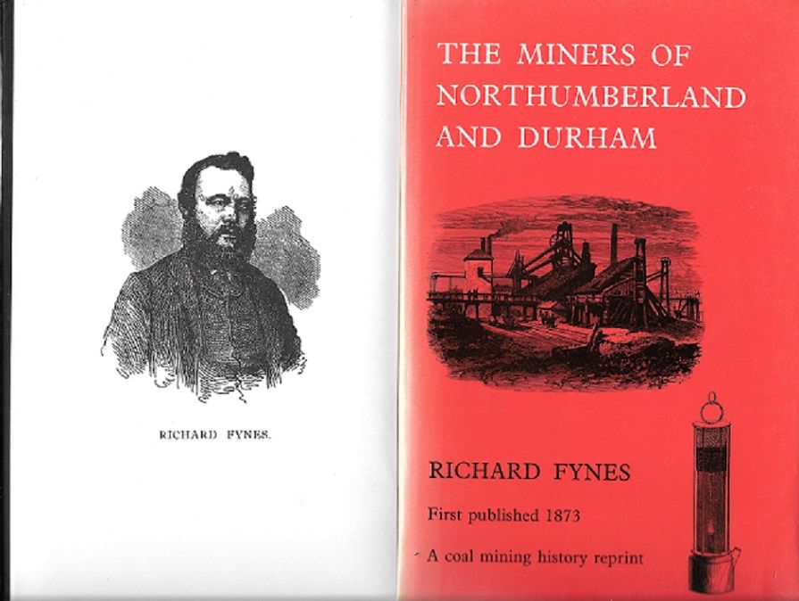
Thanks for posting this interesting newspaper clipping from the Morpeth Herald reporting on the Miners’ Picnic held at Blyth Links in 1864. The person who opened the proceedings was Richard Fynes, who was the author of the book “The Miners of Northumberland and Durham”. The comments below are taken from his book as they provide some background to the reason this meeting would have been arranged. It was held on Monday 5th September 1864, organised by Northumberland Miner’s Mutual Confident Association (The name of the union). The date of the meeting is significant as the union had only just been established a few months before the meeting and this was probably the main reason for the meeting. This was the first time that the Northumberland miners had their own independent union and the key person in the establishment of the union was Thomas Burt who was at that time a “hewer” at Choppington Colliery and was their union representative. He was later General Secretary of the union, then MP for Morpeth. (Burt Hall, now part of Northumbria University is named after him.)
Fynes' book is mainly about two major concerns affecting the miners at that time.
The first was the unbelievably harsh conditions of employment – among other things, the owners could sack and evict at will. The other was safety. In the mid 1800’s, 1000 lives a year were being lost in colliery accidents mostly due to methane explosions. There is a reference in the article to a “candle and powder fund”. This was a bill introduced to government to prevent the use of candles and gunpower in fiery collieries. It was not passed. The 1862 Hartley Colliery Disaster that resulted in the death of 204 men and boys would have been still fresh in everyone’s mind and Hartley Colliery was only a few miles from Blyth Links. Due mainly to the pressure from the unions, the law was changed through various Acts of Parliament and most of the demands made by the unions was met.
The miners unions were also fighting for political rights. In 1864, when this meeting was held, to be entitled to vote, one had to own property so miners had no right to vote. This was changed in 1867 to allow those who rented property to vote. In Bedlington and other collieries in the Shire, because miners’ accommodation was free, they did not pay rent, therefore they were not entitled to vote. Fynes’ book describes how Dr Trotter (and others) fought against this interpretation of the law on behalf of the Bedlington miners to have this ruling changed - another reason why the people of Bedlington thought so highly of Dr Trotter that his monument was paid for by public subscription. (It used to have a prominent position in the town, now relegated to the verge!)
I recommend Fynes’ book for anyone interested in the social and industrial history of the area - it's available on Google Books.
-
1
-
1
-
-
I included everything relating to his military record in my message. Can't help any further - sorry.
-
If you are a member of Ancestry.com you will find quite a bit information on James Bonner Archbold. He appears in the Archbold – Dodd family tree. It shows where he lived with his sister Alice A Archbold and other family members in the 1891 and 1901 census. You appear to be more interested in his army service and the records below are copied from the Archbold – Todd tree.This information may not be correct but it looks pretty convincing.
UK, Royal Hospital Chelsea Pensioner Soldier Service Records, 1760-1920
Name James Bonner Archbold
Age 18
Birth Date abt 1886
Birth Place Bedlington Northumberland
Service Start Year 1904
Regiment Gordon Highlanders
Regimental Number 9551
Attestation Paper Yes
Global, Find A Grave Index for Burials at Sea and other Select Burial Locations, 1300s-Current
Name Pvt James Archbold
Death Date 26 May 1915
Cemetery Ypres (Menin Gate) Memorial
Burial or Cremation Place Ypres (Ieper), Arrondissement Ieper, West Flanders (West-Vlaanderen), Belgium
Has Bio? N
URL http://www.findagrave.com/cgi-bin/fg.cgi?page=gr&GRid=10868064&ref=acom
The Menin Gate is a mausoleum. It pays tribute to those servicemen whose bodies were never recovered. The internal walls are engraved with the names of those who have no known grave
-
1
-
-
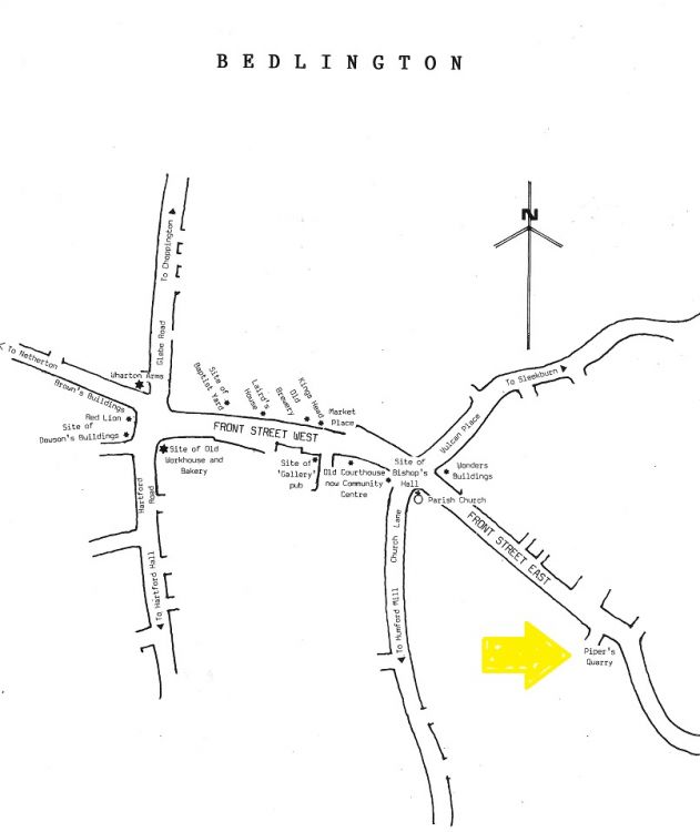
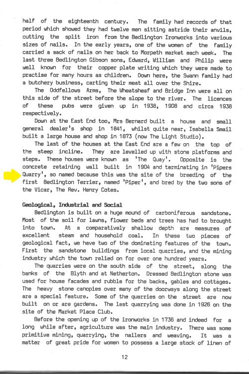
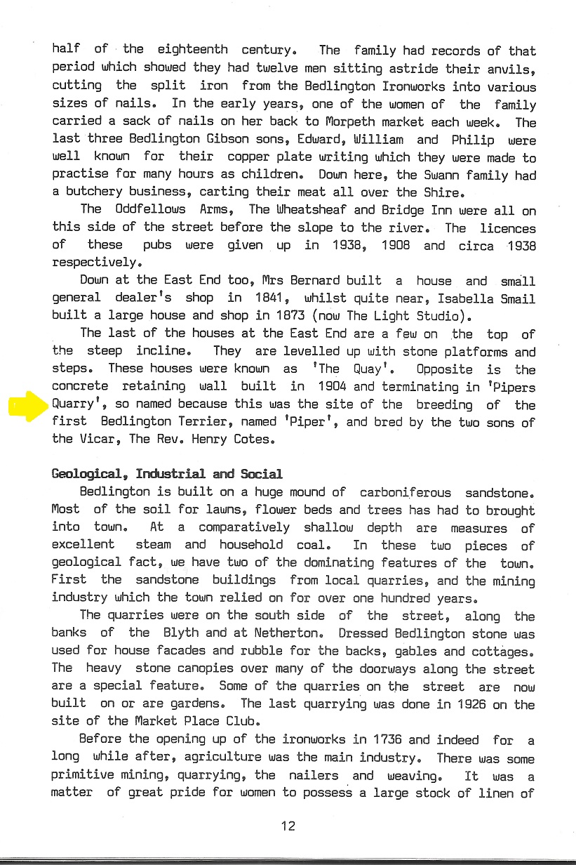
In Stephen Martin’s booklet “Bedlington”, there is a map of the town that shows the location of Piper’s Quarry and on page 12 there is an explanation of how it got it's name.
-
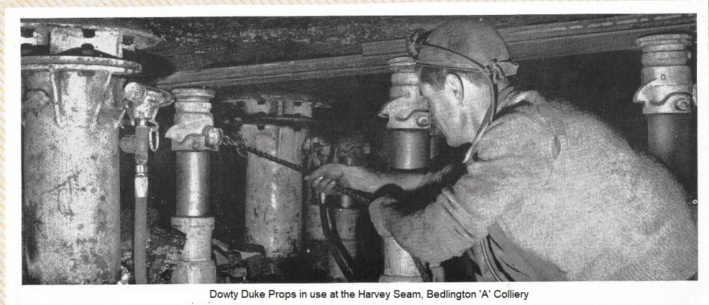
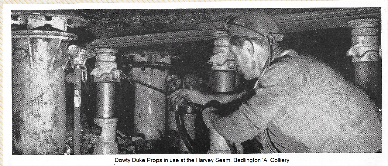
The photo was cut out a Dowty Mining Equipment Ltd advertisement brochure I obtained in the late 60's. Their information is obviously incorrect!
-
On 11/21/2017 at 21:10, pilgrim said:
waggon ways -- not sure where my post on this went?? but there is a waggonway from the above mentioned PLESSEY site -- it starts somewhere beside the old windmill aside what used to be MSD and carries on in the middle of the dual carriageway to the east and thence to Blyth. it is most easily seen between the dual carriageway on the rise up to Laverock hall. this was in use in at least 1709 and was used until at least 1812
There is a bit about local waggonways on this site
http://www.seenewcastle.com/subjects/waggonway/
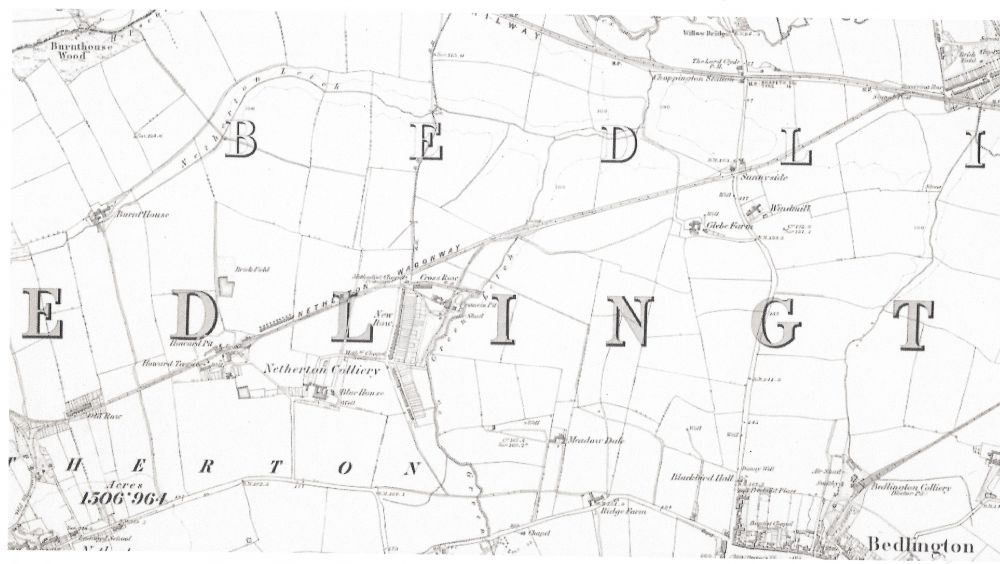
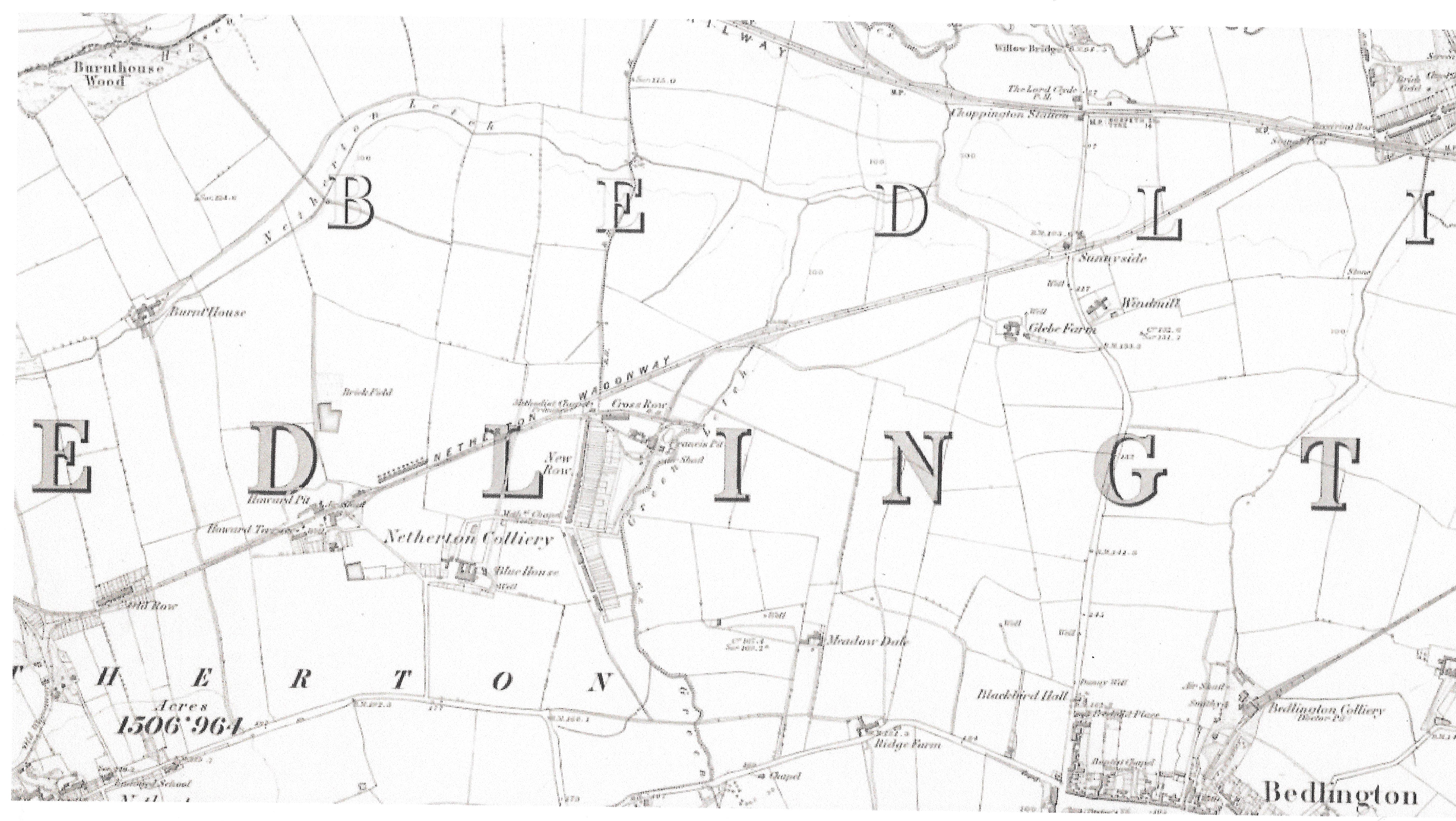
The attached 1860 map shows the Netherton Waggonway that connected Netherton Colliery to the main railway line at Barrington.
One could still walk along the section between Netherton Colliery and the Choppington Road in the 1950’s.
-
1
-
-
The same seam often had a different name at another colliery,
e.g The Beaumont seam at the Doctor Pit (Bedlington D) was called the Harvey seam at the Aad Pit (Bedlington A).
On page 15 of the report, this is clarified with the best piece of technical jargon I’ve read in ages -
“Seam nomenclature suffers considerably from homonyms and synonyms, arising both from mis-correlation and from the plethora of local names introduced by private colliery companies.”
To prevent the confusion that can arise using the names of seams the NCB assigned letters to the seams, The Harvey is N, The Plessey is M etc. The report makes use of the letters in the report.
-
1
-
-
It was a surprise to find out that, according to the comment below taken from the report, there are records of coal being mined in this area going back almost 800 years.
"The Moorland Seam is named from Bedlington Moor Land, near the present Bedlington Station, where the coal was mined at least as early as the 18th century. One of the earliest records of local mining in England is near Blyth, where, in 1236, the Moorland Seam was worked along and near its outcrop westwards through Cowpen to Bebside.”
-
1
-
-
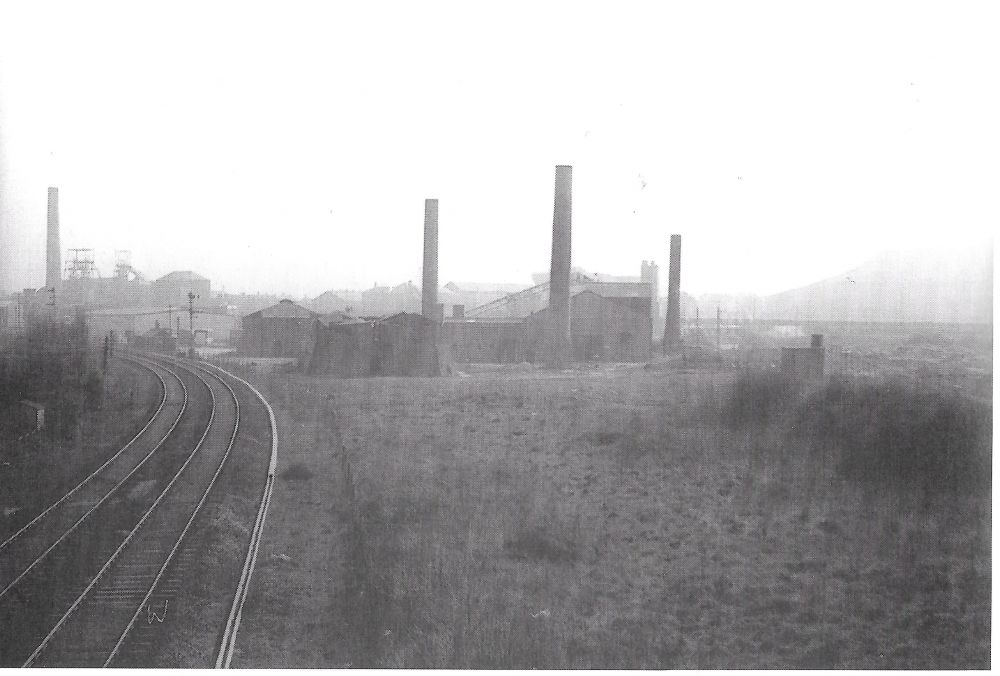
This is not Bedlington Station Brickworks and but is almost certainly the Bedlington Brickworks. The Bedlington skyline can be seen in the background and the row of houses at the back of the brickworks is probably South Row.
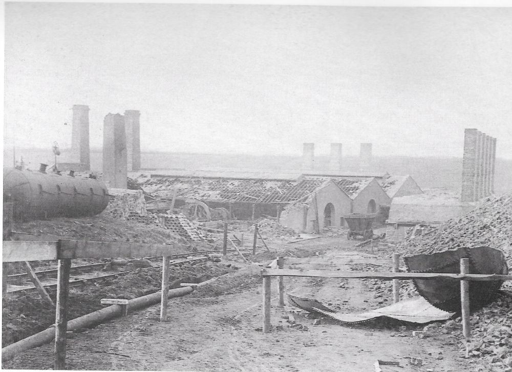
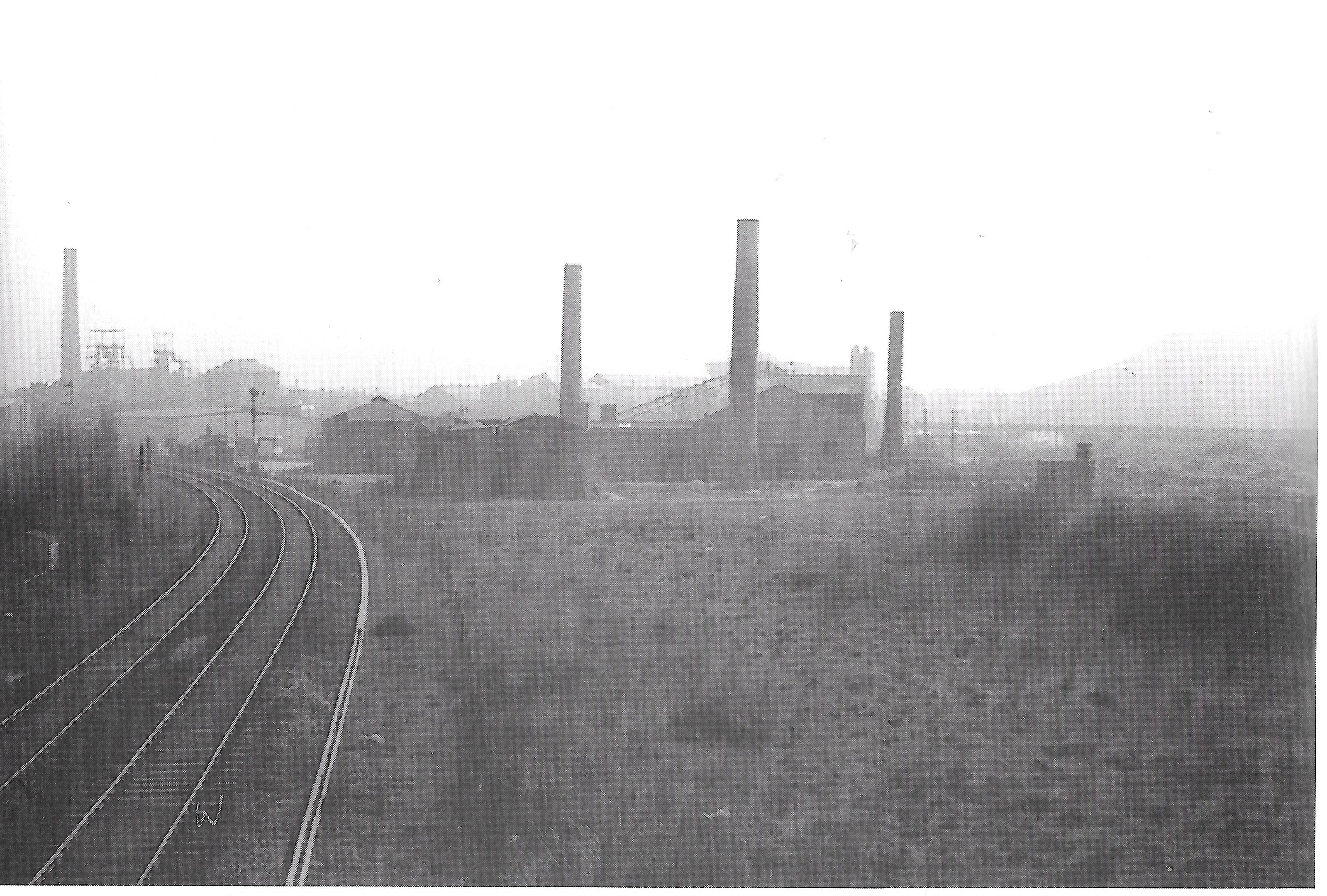
The Brickworks at Bedlington Station were known as the Barrington Brickworks and in the attached photo you can see the Barrington Brickworks in the 1960’s with the Bedlington “A” pit in the background. (The “Aad” Pit). The discard dump at the extreme right of the photo is now Gallagher Park.
The other photo shows the Barrington Brickworks in 1894 after a boiler explosion demolished the works.
-
1
-
-
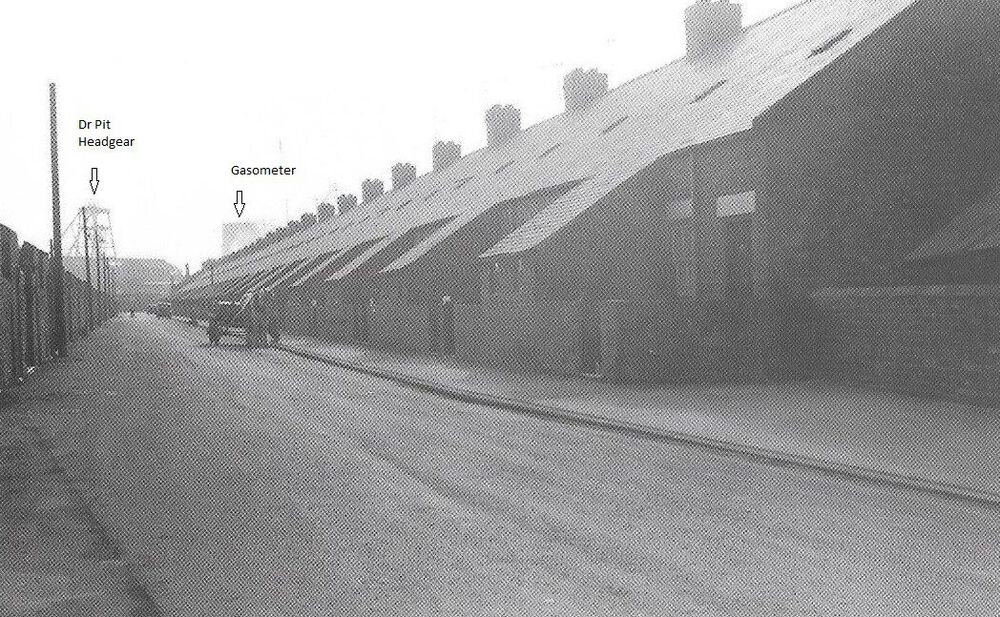
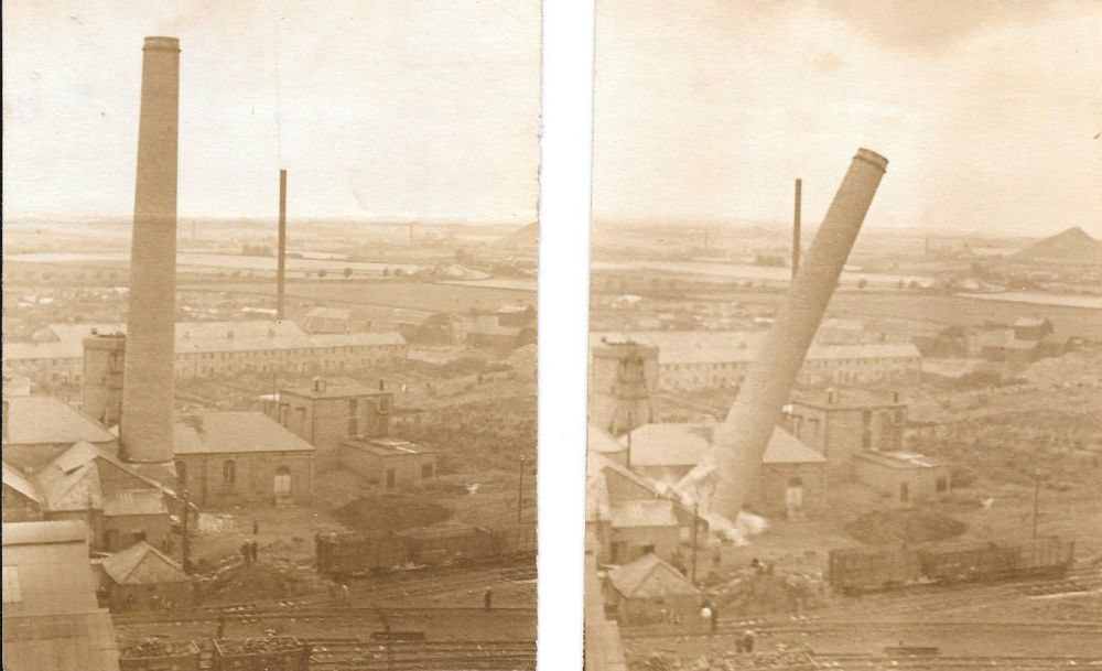
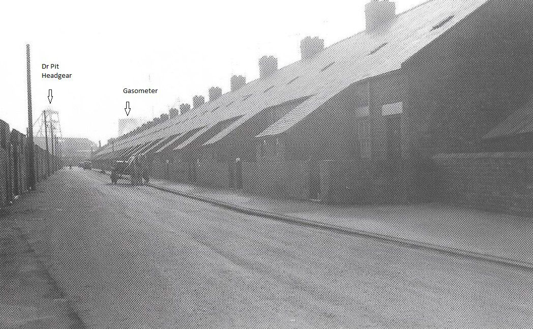
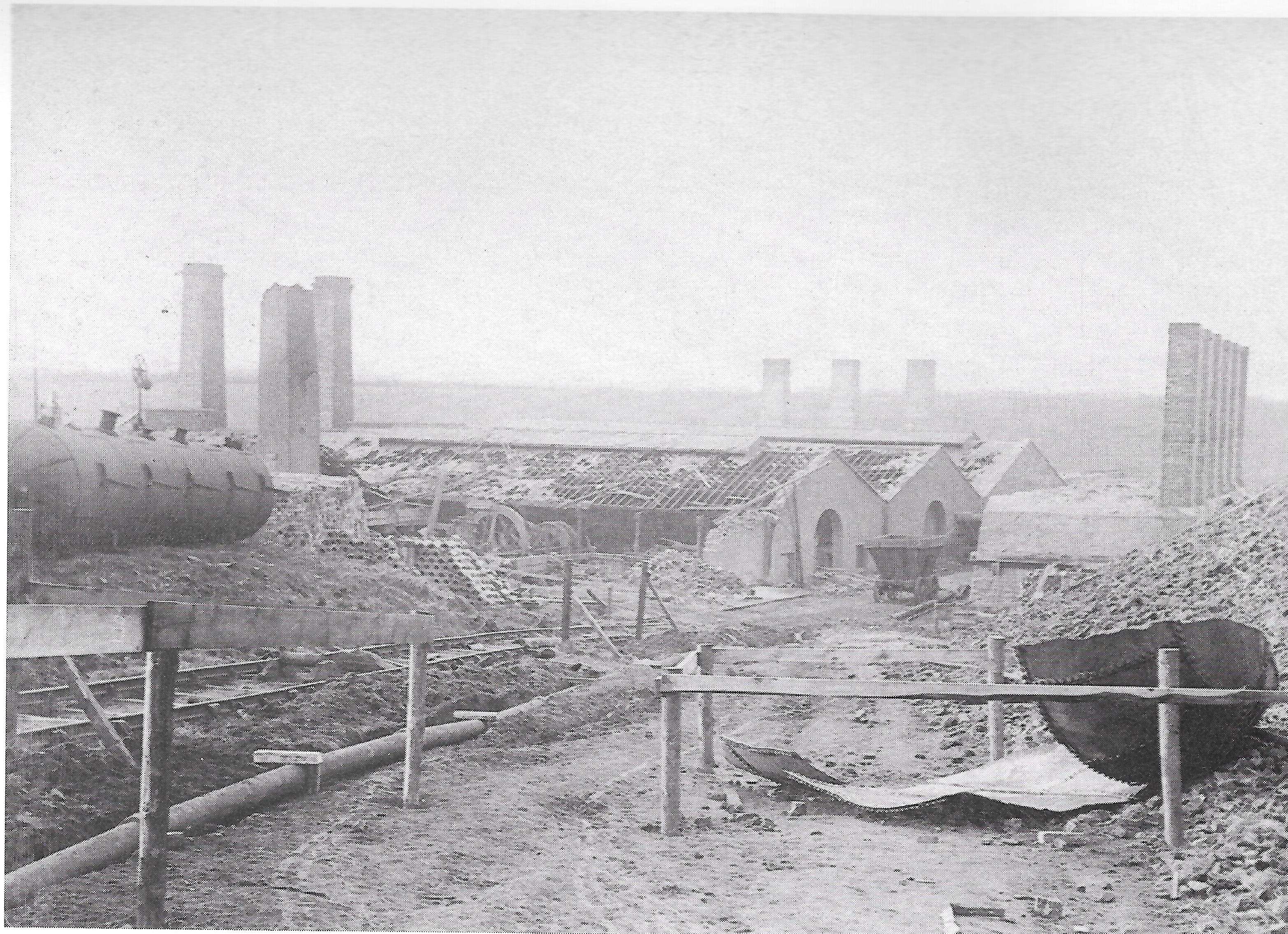
At the Doctor Pit on Sunday August 10th 1952 the chimney that was part of the steam plant that was used to drive the John Pit winder was demolished in a controlled explosion. The steam winder had been replaced by one driven by electricity so the chimney was no longer needed.
It was quite a spectacle for all of us as it could be seen from most parts of the town. The small chimney at the back was part of the brickworks and Telephone Row is the row nearest the pit.This part of the town has changed quite a lot in the last 65 years.
-
2
-
.jpg.8fc402b6ee049c4d947bb09b1ad9d082.jpg) You can see from this angle that there was quite a large extension to the hall not visible in the first photo.
You can see from this angle that there was quite a large extension to the hall not visible in the first photo.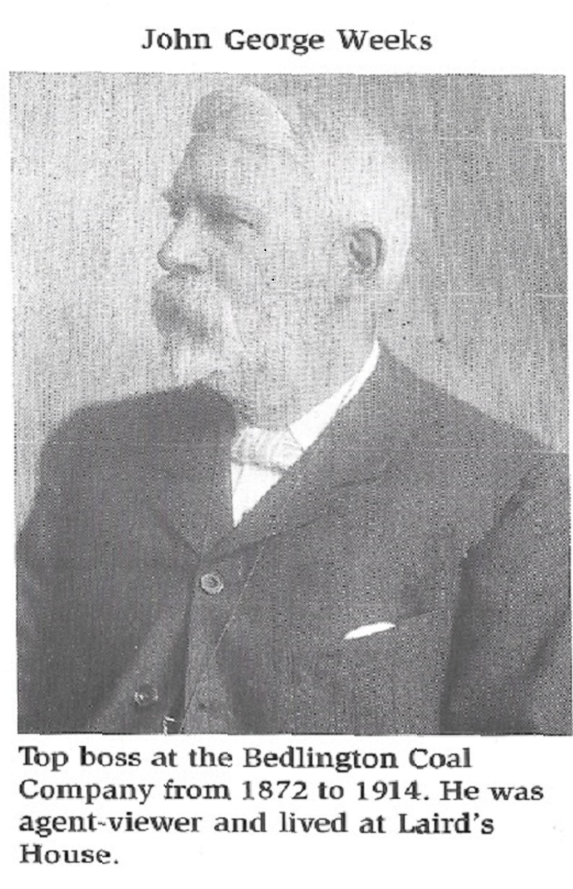


Co-oP and Library
in History Hollow
Posted
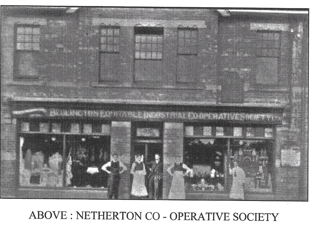
According to one of the "Bedlingtonshire Revisited" booklets, there was a branch of the Bedlington Coop at Netherton Colliery