


James
-
Posts
204 -
Joined
-
Last visited
-
Days Won
49
Content Type
Forums
Gallery
Events
Shop
News
Audio Archive
Timeline
Posts posted by James
-
-
On 21/01/2022 at 21:02, Canny lass said:
Sorry, editing problems again!
continued;
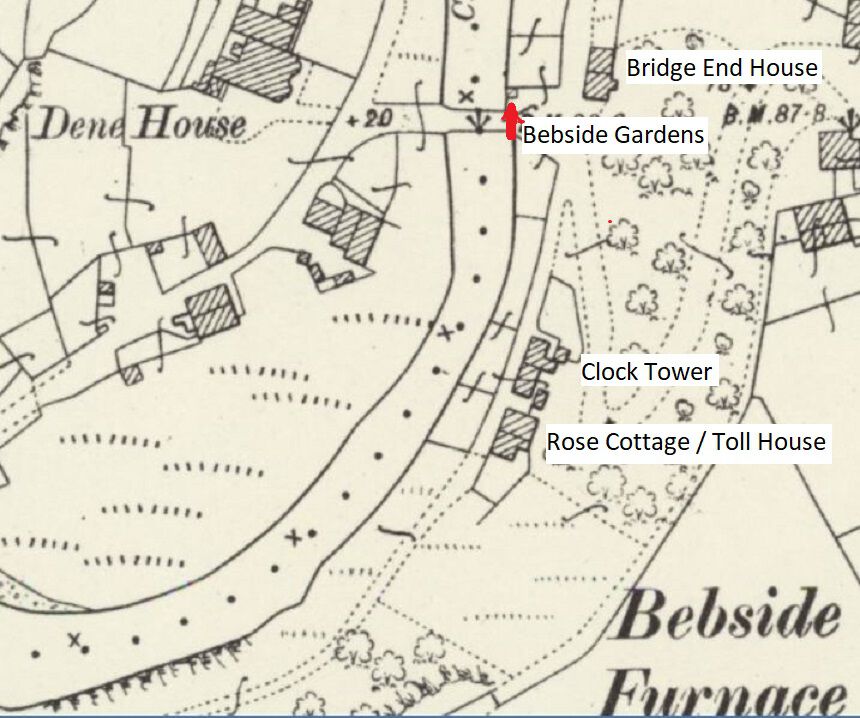
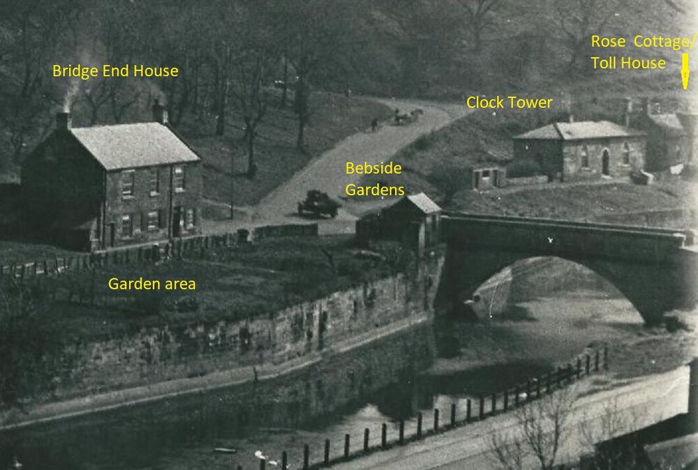
On every census record I've waded through over the years for the riverside area, Rose Cottage is next door and to the east of Clock House. There are no further dwellings recorded in an eastward direction along the river. When the enumerator moves from the Iron Works towards the bridge and hairpin bend he records the dwellings in the order: Bridge House (sometimes called Bridge End House), Clock House and Rose Cottage before goung up the hill to Se View, paradise Row etc.
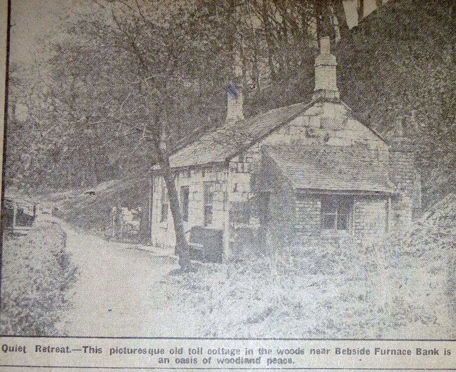
In John's picture there is a gate leading into, or out of the Halfpenny Woods. This suggests to me that it is the Toll house and I believe it to be on the riverside (there were several Toll Houses on Lord Ridley's land, at least one up on the hill), as the ground slopes steeply upwards behind it.
Comparing John's Toll sign photo and his Toll Cottage photo of 2013 suggests to me that the sign was placed at the right corner of the gable end facing away from the photographer in the cottage photo. A very small portion of that gable end is seen on the right of John's sign photo. It has a very, very short eves over-hang and a tree, behind a block stone wall, immediately to its right. Furthermore, there is a down-pipe from the gutter which leans slightly inward towards the bottom. All three are also present in John's cottage photo.
Assuming that the sign is placed to be read by people entering the woods, I believe the Toll Cottage photo to be taken from inside the woods and therefore looking towards Bridge House. Therefore, I think that it may possibly be a dwelling recorded as Bebside gardens in the 1901 and 1911 census. The gardens skirted the river bank on the Bebside side of the river.
Canny Lass.
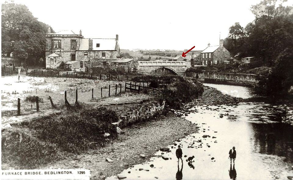
Your comments have got me interested enough to investigate the toll house a bit further. In the 1950’s I walked through the Ha’Penny woods a number of times so I must of passed the Toll House but I cannot remember ever seeing it. In the 1901 census, there are on 4 properties around furnace bridge on the Cowpen side of the river, recorded in the following sequence- Bridge End House with 4 families; Bebside Gardens with only 1 resident; Clock Tower with 2 families; Rose Cottage with 1 family.
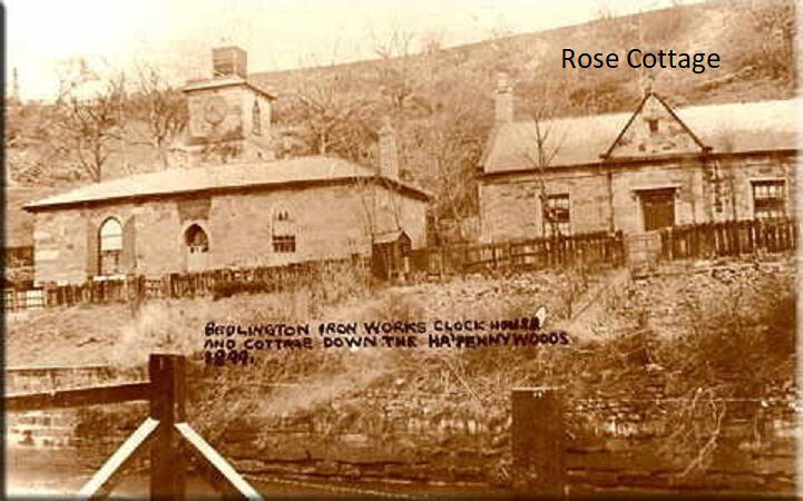
These 4 properties are shown in old maps from this period. The toll house has to be one of these buildings and it can only be Rose Cottage. Comparing the old photo of Rose Cottage with the toll house in the newspaper cutting , the windows, chimneys and gable ends are the same, the only difference being the fancy roof above the entrance door which could easily have been modified. The location is exactly where the toll house was situated - at the entrance to the woods on the footpath and there were no other building where a toll could have been as can be seen on the old map. Bebside gardens is the only house that is unclear but I believe it was the building that Joe asked about that started off this topic i.e the building next to the bridge opposite Bridge End house. The single occupant of Bebside Gardens in the 1901 census was a ‘gardener’ and next to the building is a huge garden. A gardener living in Bebside Gardens alongside a large garden!
-
 1
1
-
-
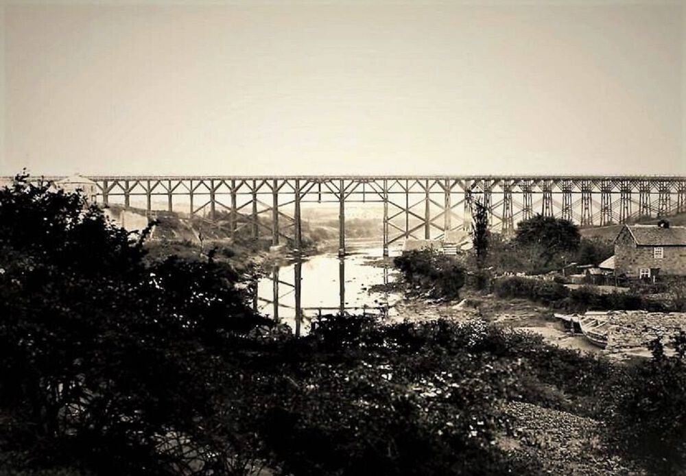
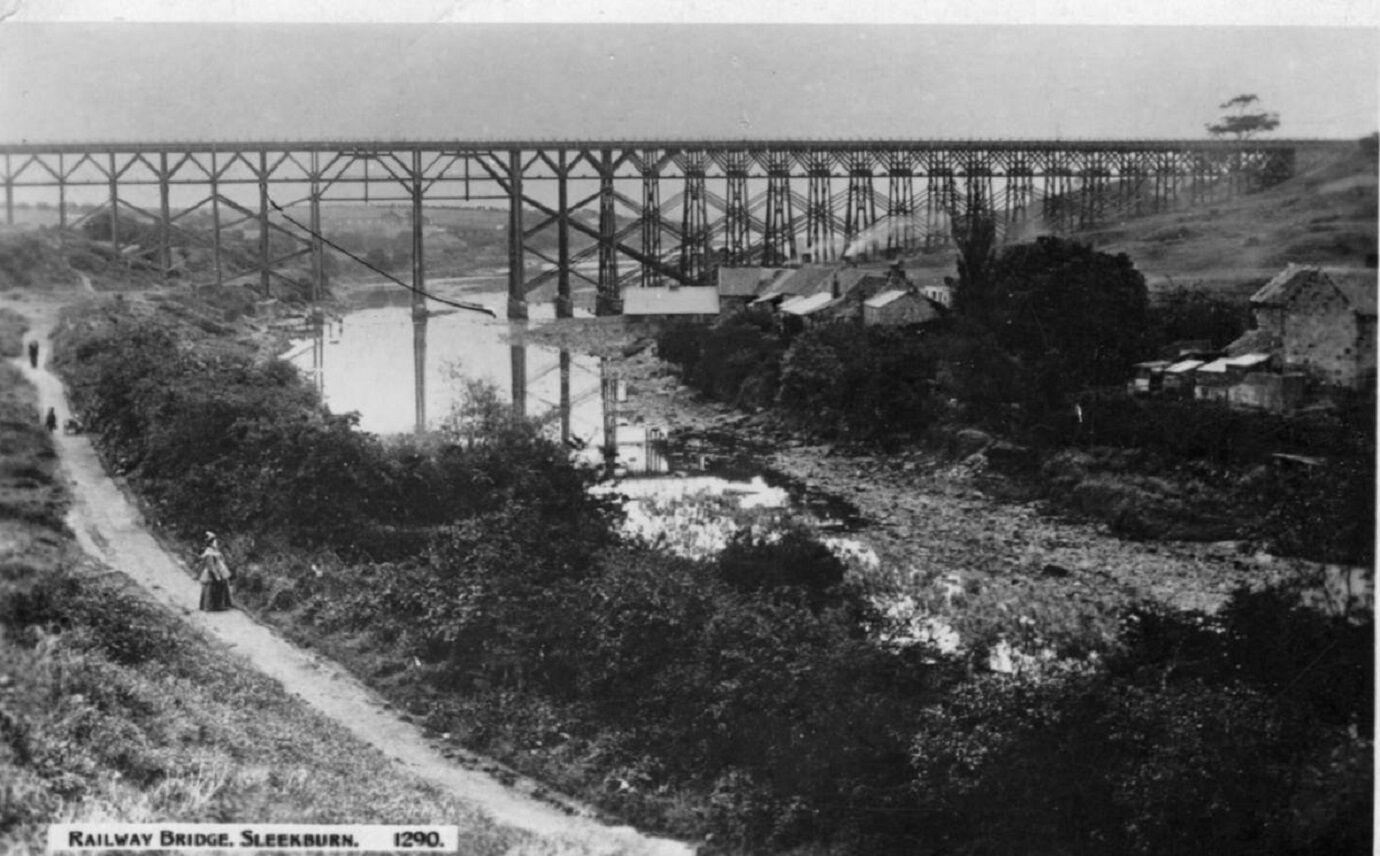
Two earlier photos of the Rose & Crown showing the wooden bridge. The Bedlington Coal Company built the first Bedlington Viaduct in June 1850 as part of its line from Newsham to Bedlington. It was a timber trestle bridge designed by Robert Nicholson, 80 feet high and 770 feet long. (From article “Bridges on the Blyth”) In 1930 the old wooden structure was demolished by the London and North Eastern Railway and was replaced by the present iron bridge (The Black Bridge). (From article “Bridges on the Blyth”)

-
1
-
-
On 20/01/2022 at 12:11, Joe Ridley said:
Can anyone tell me what the small building was on the end of Furnace Bridge? (see pictures). I wondered if it had been a small shop? Was the Furnace Bridge ever a toll bridge?
Joe
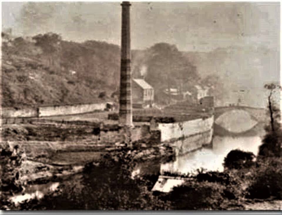
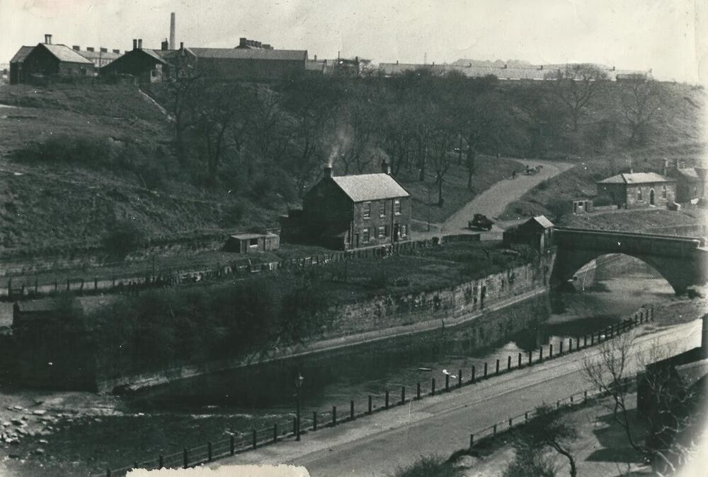
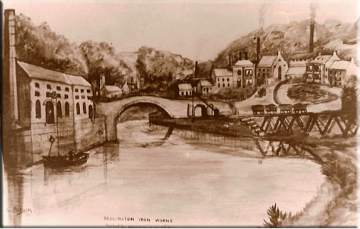
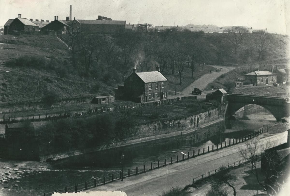
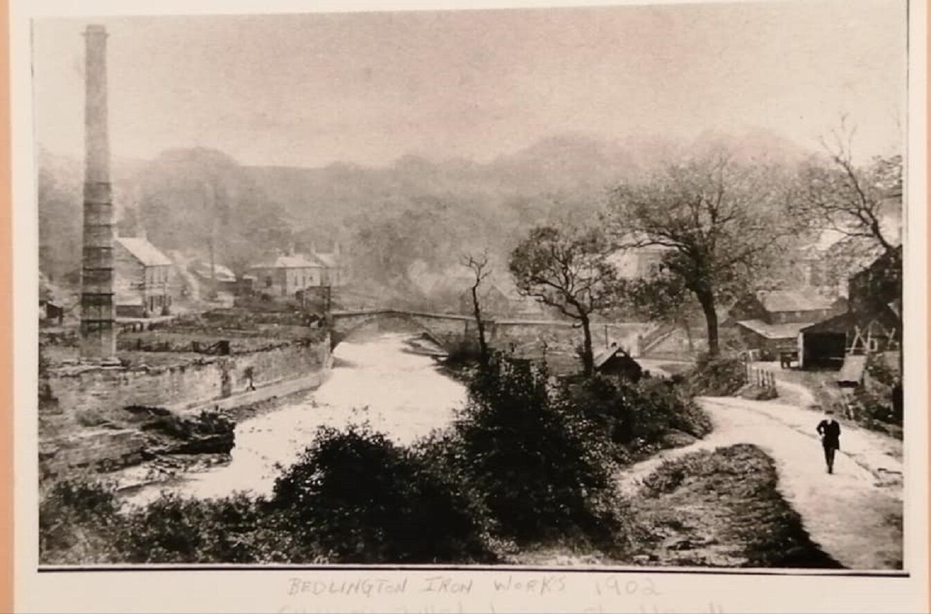
The sketch and 2 photos are all looking upstream towards the furnace bridge.
The sketch by C Bergen (presumably Christopher Bergen who wrote the article about the ironworks) shows the chimney and attached buildings are built on the quay, and the 1902 photo shows they have been almost completely demolished, except the chimney. However it does look like there a small building remaining next to the bridge that could be the small building mentioned by Joe.
The sketch shows a ship being unloaded or loaded so the buildings must have been warehouses for storage of goods that have been unloaded or are for loading onto ships berthed at the quay. Even today you can see the steel mooring rings anchored into the side of the quay.

-
1
-
-
On 06/01/2022 at 14:59, Alan Edgar (Eggy1948) said:
@Sloopy .Dog - never sen it refered to as a church but according to a transcipt on the Iron Wporks by Christopher Bergen the inscription above the door was :-
.....................From Hawkes and Longridge the concern passed to Biddulph and Gordon, of
London. It is difficult to decide when their ownership began or ended. Wallace says
that they held them for 50 years. In that case they must have acquired them at the
sale just mentioned, but in the ‘New County History.’ Mr Forster, quoting ‘The
Industrial Resources of the Tyne, Tees and Wear,’ says they acquired them in 1809.
This, of course, makes Wallace’s statement impossible. They certainly did hold them
in 1829. The clock house appears to have been built by them, a stone over the door
being carved with the date 1829, the initials of ‘G & B’ and a Latin inscription
‘VIVITUR IGNE ET AQUA ET FERRO DEO FAVENTE,’ of which a rough rendering
would be: ‘We live by fire and water and iron and God’s favour’...............
Bedlington Ironworks- Christopher Bergen.docx 39.57 kB · 6 downloads
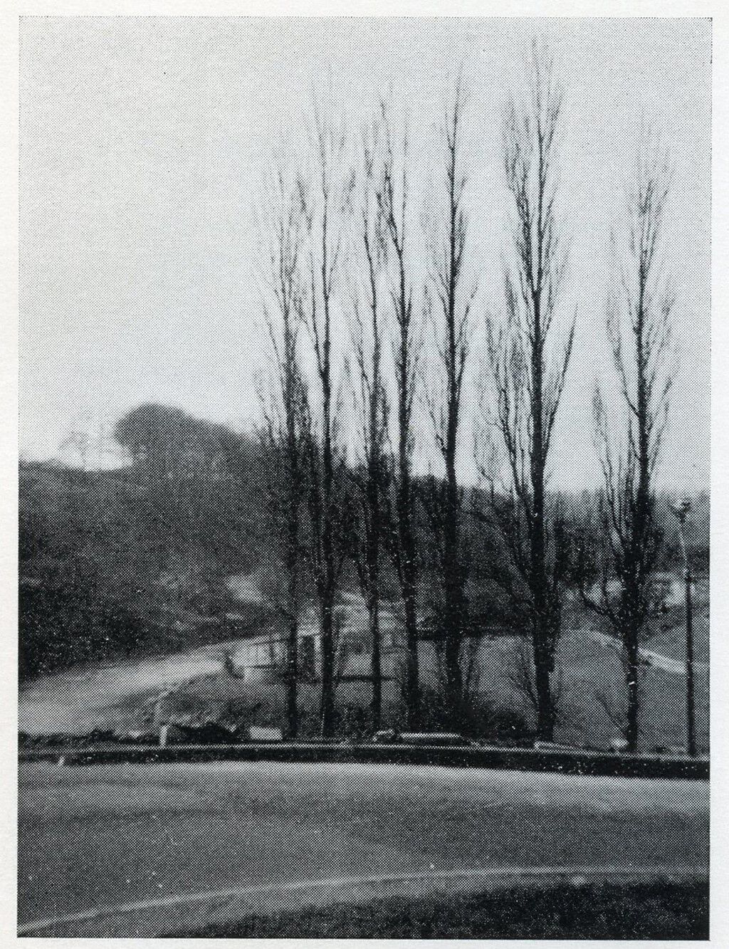
In Evan Martin’s book ‘Bedlington Iron and Engine Works’, he states that in 1829 a workmen’s institute was built where books and newspapers could be read and courses were run for the employees. He goes on to say that inscribed on a stone in the institute was the company’s motto ‘Vivitur Igne et Aqua er Ferro Deo Favente’ (We live by fire, water, iron and the grace of God) Although he doesn’t say that this was the clock house, after reading the document written by Christopher Bergen posted by Canny Lass, it must have been. Bergen’s document says the Clock House had a stone above the door with the same motto mentioned by Evan Martin with the date 1829. He also states the Annual Meetings of the Relief Fund was held here followed by a dinner provided by management. It would appear that the clock house was the workmen’s institute converted to housing after the works closed. I have attached an old photo of the bandstand taken from the hairpin bend behind the 7 poplars we used to call the ‘Seven Sisters’.

-
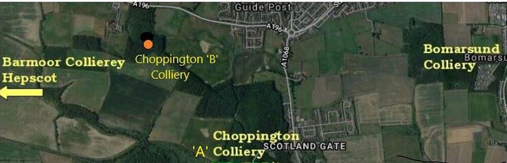
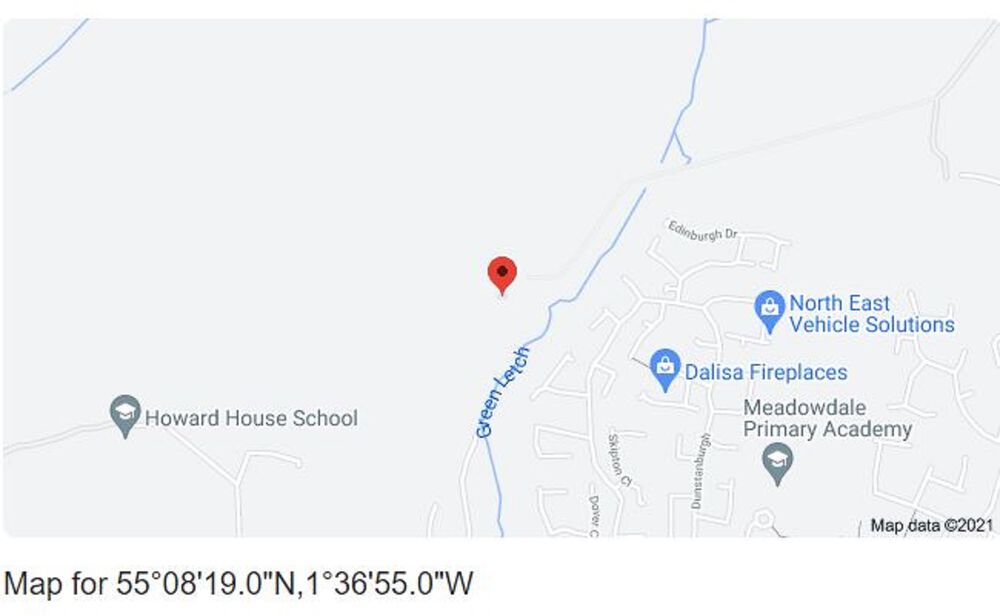
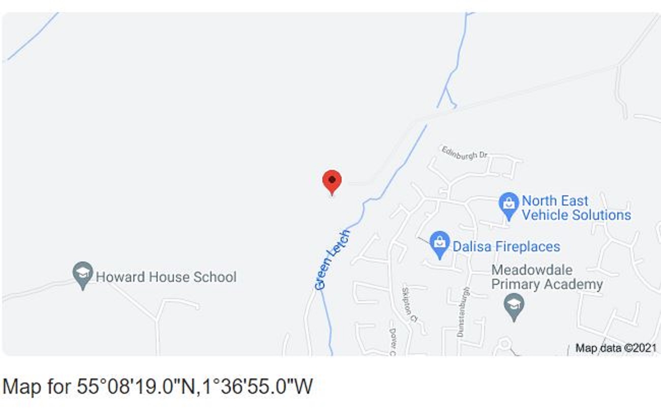
14 hours ago, Alan Edgar (Eggy1948) said:
Cheers James - image updated. I'm assuming the Choppington 'A' & 'B' pits were right nest to each other. The DMM site only has the one entry but does say 'A' & 'B' pit
")
Hi Eggy,
I have added the exact location of Choppington ‘B’ to your map.
-
1
-
-
22 minutes ago, James said:
To make sure I don't upset (HPW), there were two Choppington collieries - Choppington 'A' (the low pit) and the pit where HPW worked, Choppington 'B' (the high pit)
-
 1
1
-
-
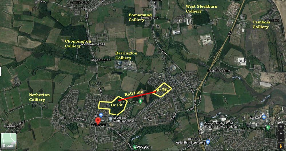
On 04/01/2022 at 14:33, Alan Edgar (Eggy1948) said:
@Sloopy .Dog - I have added the names of collieries I can remember that were in the area - don't think I've missed one but @HIGH PIT WILMA will keep me right. There was a railway link between the tow Bedlington pits and they both dumped the waste onto the same pit heap.
Hi Eggy
The only one you've missed is Barmoor colliery and was just off your map. It was on the Nedderton - Morpeth road just past Hepscott in the "dip" behind the row of houses on the right side of the road driving towards Morpeth. It was the smallest pit in the Bedlington group of collieries.
-
1
-
 1
1
-
-
-
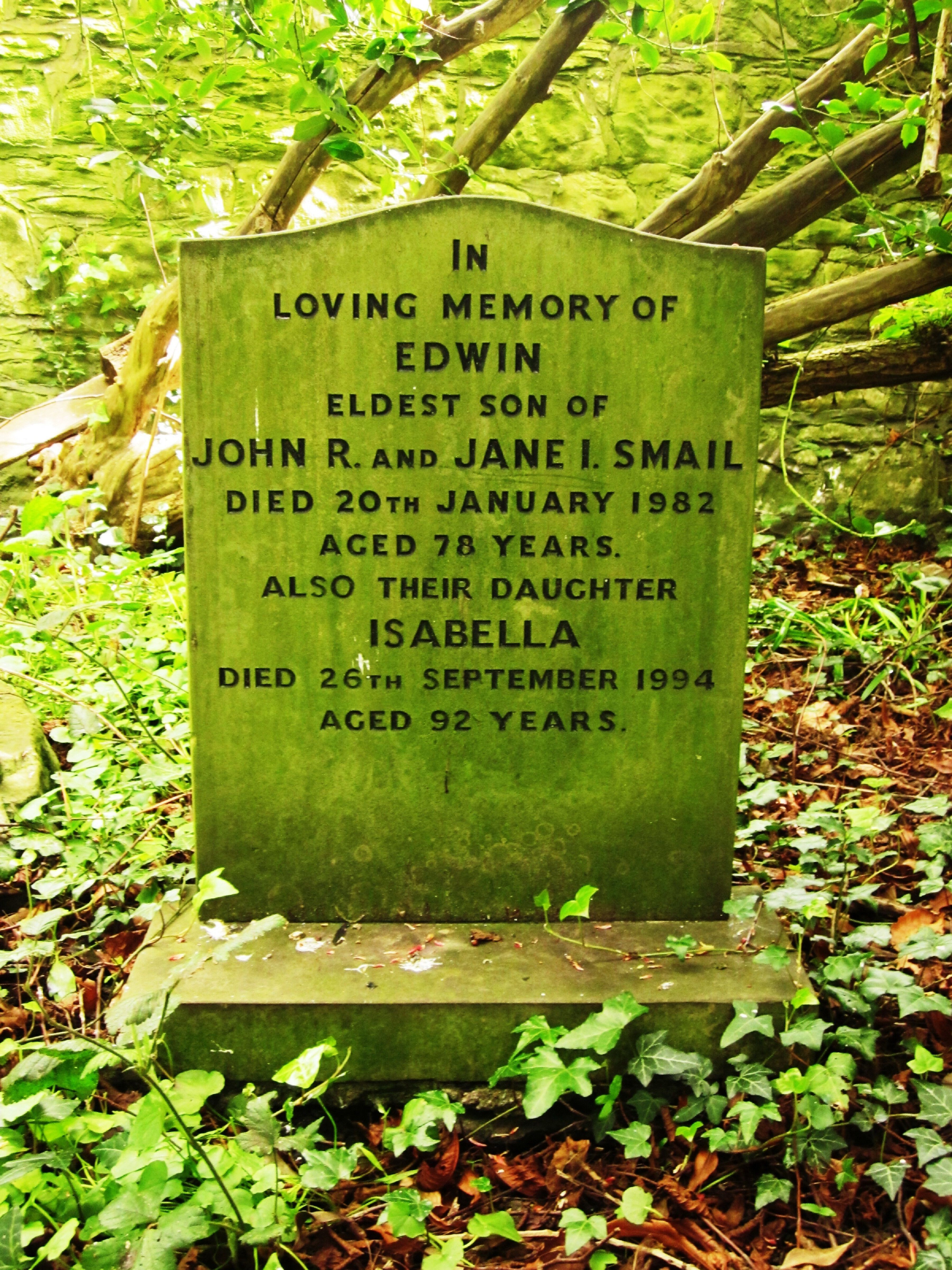
In the 1939 census Jane Isabella Smail was living in the shop with her daughters Isabella and Catherine.
-
1
-
-
On 25/10/2021 at 15:51, Maggie/915 said:
Hi Vic
Todays visit time Saint Cuthbert photo .So pleased you remember this lady .I have taken other photos if anyone interested .
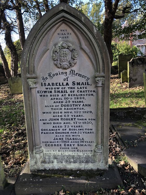
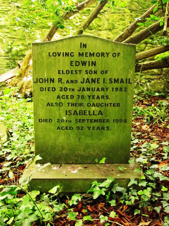
The 3 members of the Smail family who lived and worked in the shop in the 1950’s were Edwin, Catherine and Isabella. Isabella was the organist at St Cuthbert’s for many years. Their mother was Jane Isabella and their father was John Robert and according to the headstone posted by Maggie, he was the organist for over 50 years. What you can’t see on the photo is the last inscription on the headstone that was for Catherine who died in 1990.
The photo attached is the headstone for Edwin and Isabella and this is also in St Cuthbert’s graveyard.
-
1
-
1
-
-
Sid Newman lived in No 1.
Am I correct in assuming that Joyce Dagless is your wife’s sister? She worked at the glove factory and married Colin Hall who was undermanager at Bates Colliery and they moved to Smoky River coal mine when it opened in the late 60’s.
-
2
-
-
The Redpath's from Hollymount Square - Brian lived in No. 3 (or was it No. 2?) and his dad was called Fenwick. Robert lived in No. 53 and his dad was called Jimmy. Fenwick and his elder brother Jimmy both worked at the Doctor Pit.
-
1
-
-
On 18/07/2021 at 21:54, lilbill15 said:
Photos six and eight are 6) Blue House Farm through the trees immediately to the West of the plantation which I think sits on top of where Francis Pit was. photo 8 looking back from Blue House Farm towards the trees on the site of ?Francis pit, new estate on the horizon. For my next trick I will attempt to conjure up the OS map for the area:……
I have entered the coordinates of the Francis Pit from an old map and the red map indicator should be its exact position. If you enter the coordinates shown on the photo on a GPS if should take you there.
-
2
-
-
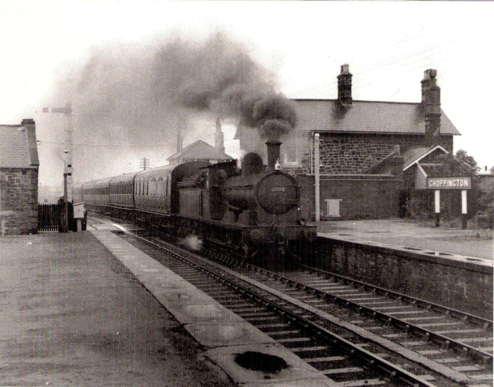
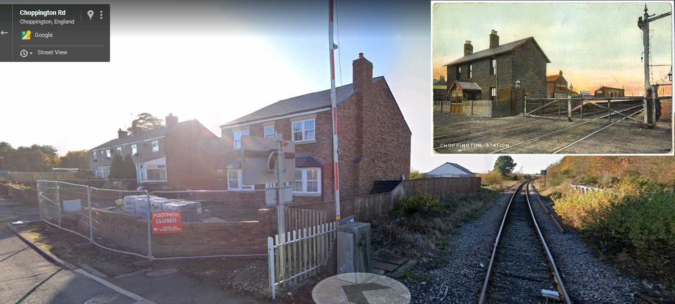
16 hours ago, Alan Edgar (Eggy1948) said:
It will be approximately 18 months since I drove passed Station Terrace, Choppington, but I knew they had started building there as they prepared the land where the old Station House used to be and had started to build a new house. I don't know if it was the same builder that built the equestrian centre, or if it was part of a deal with the council ie yes you can build the equestrian centre as long as you build a house where the old Station House used to be
 , but Google street view (2020) shows the new house still under development. And you can see Station Terrace just passed the house.

Old photo of Choppington Station
-
1
-
-
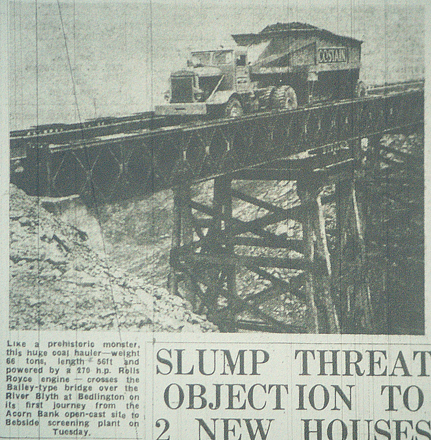
18 hours ago, Alan Edgar (Eggy1948) said:
Doesn't show the area either immediately either side of the Hartford Road but this is photo, of only a couple I have seen, shows the bridge that was built over the river Blyth for the opencast waste to be transported to the Bedside disposal site.
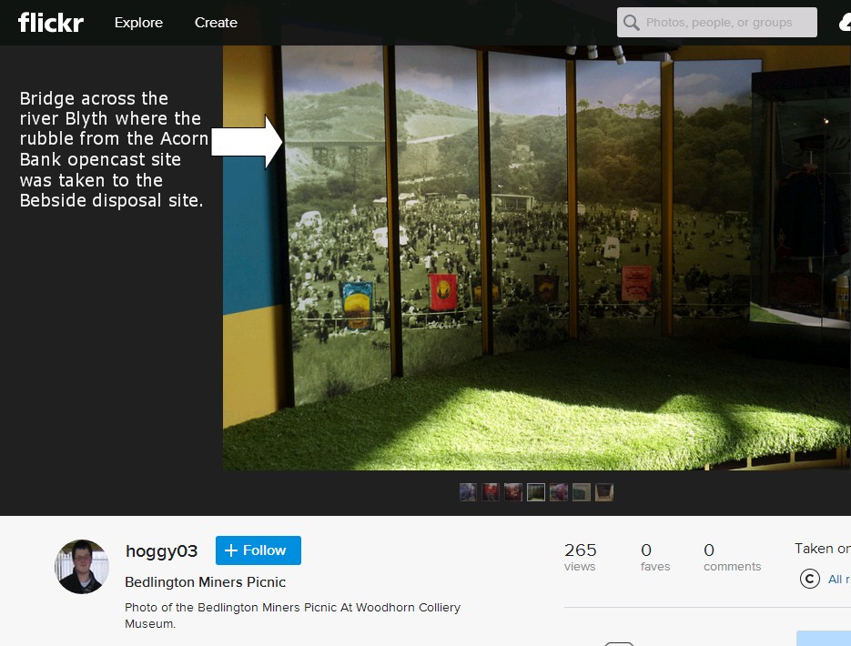
It was coal in the trucks not waste, The waste (overburden) from the opencast was put back in the “hole” and the raw coal transported to Bedside Colliery wash plant for cleaning. The photo shows the first Costain truck on the bridge.
-
1
-
-
18 hours ago, lilbill15 said:
Hi Rigger, thank you very much for this. You prompted me to have a look at older maps of Bedlington, found High Ewart Hill and Low Ewart Hill either side of the Hartford road. (?60’s), so now I know the right area. Thanks again, regards x
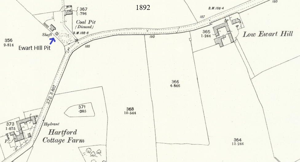
I have no dates of the years that the Ewart Hill pit was in operation but the map shows it was disused in 1897. It had only one shaft 361 ft. deep and worked the Low Main Seam. Following the Hartley Colliery disaster in 1862 when 204 men and boys died of carbon monoxide poisoning, all collieries had to have at least 2 shafts so that in the event that one shaft was out of action or damaged in some way there was a second shaft for the underground workers to use as a means of escape. I assume from this that it must have closed before 1862. If anyone can download an earlier map of the Ewart hill area it may give some idea of when it was in operation. Long after the Ewart Hill Pit had closed, the Doctor Pit mined a connecting roadway to the shaft in the Low Main seam workings and used it as a downcast ventilation shaft. You can see the shaft “cap” (a concrete cover) from the road as you walk past the farm
The photo shows the Low Ewart Hill farm that was demolished in the 1950's and the coal beneath it mined by the opencast. At the same time the road that used to pass this farm was diverted. This area is now the golf course.
-
1
-
-
On 26/03/2021 at 19:40, Canny lass said:
I can't help you there i'm afraid. I've never heard of it. I think it's an odd name - honey and sack are not two words I'd automatically put together. 'Money Sack' might be better. H and M are sometimes hard to distinguish in old handwriting. There's a farm and a place at Stannington called 'Make me rich' and I understand that it's an old name, so Money Sack sounds feasible. I do know that the second Lord of the manor married into a coal-mining family and bought land all over the area which probably included many farms. I have a book somewhere about the Ridley estate. Heaven knows where but I'll see if I can find it. It might give a clue.
HONEY SACK FARM. Could the farm have been fermenting mead? HONEY is the main ingredient in Mead. SACK is an old English term for fortified wine. According to Wikipedia, mead is also called HONEY WINE. If, in medieval times, wine was also called sack then honey sack and honey wine would have the same meaning. If this reasoning is correct (highly unlikely) then the farm's modern name would be Honey Wine Farm - sounds quite nice!
-
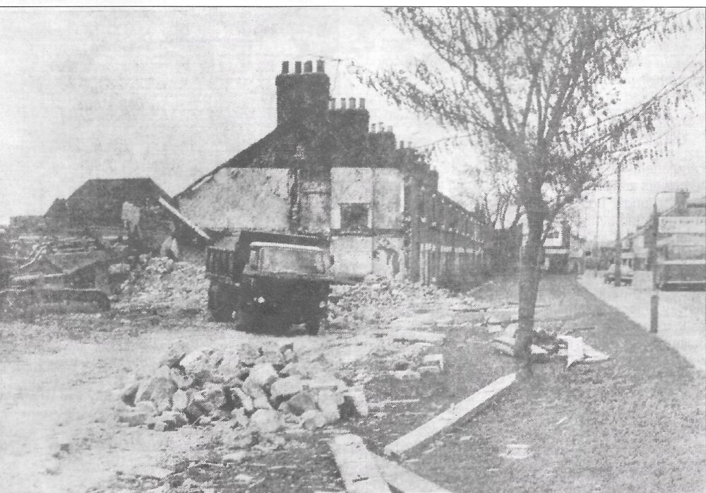
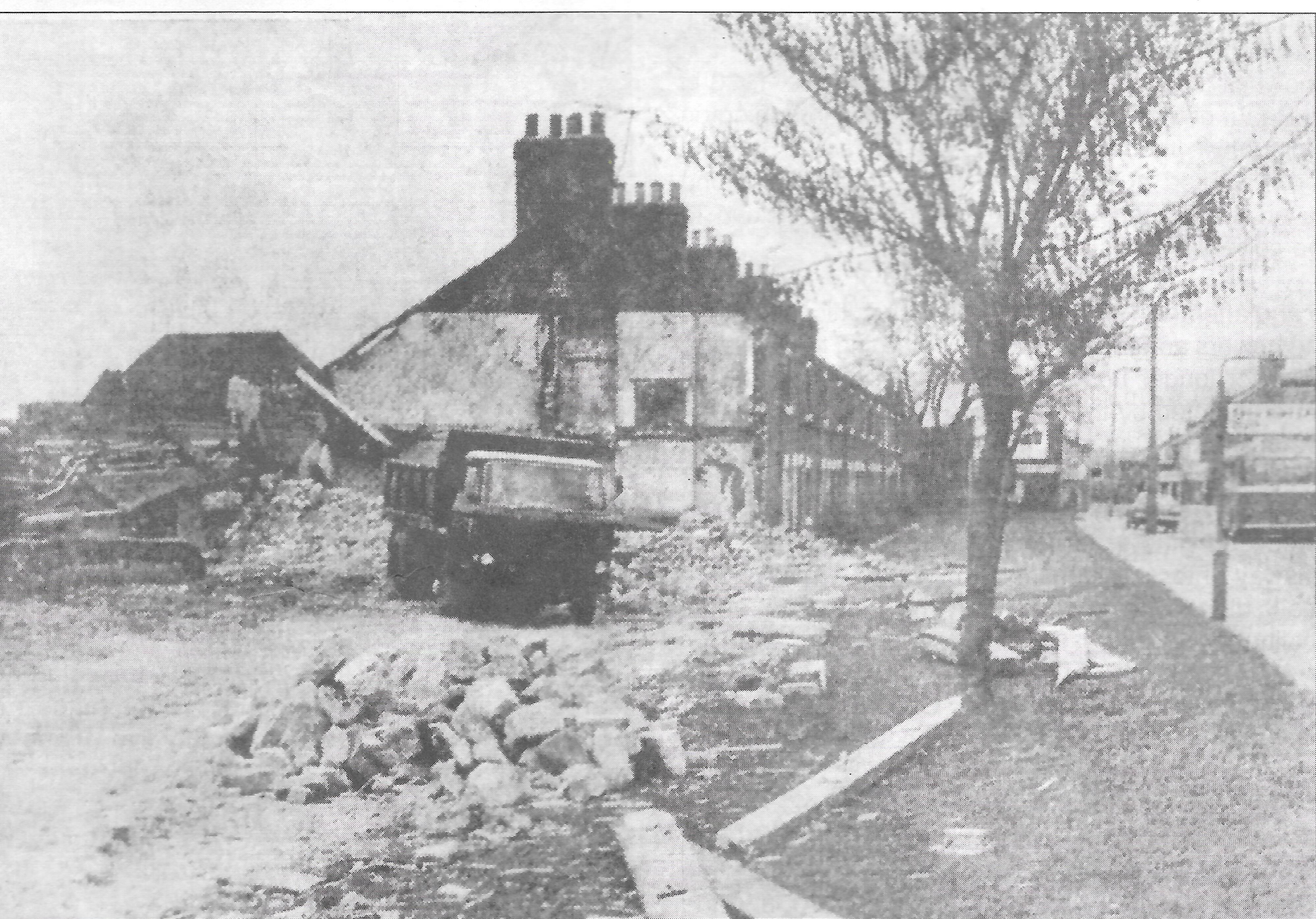
Demolition of South Row - 1974
-
1
-
-
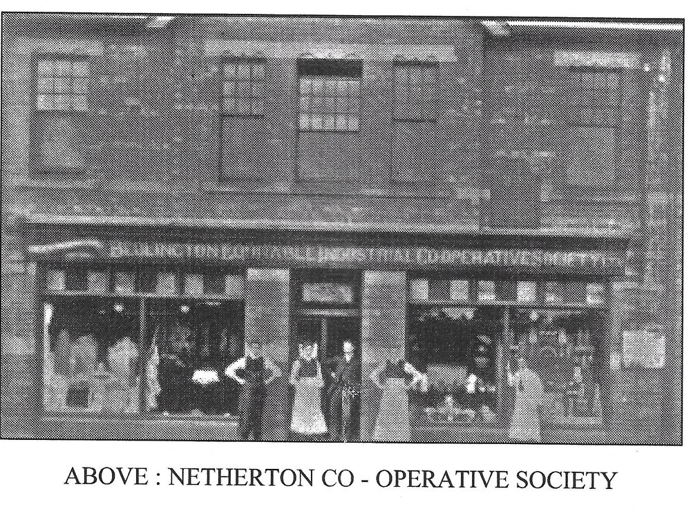
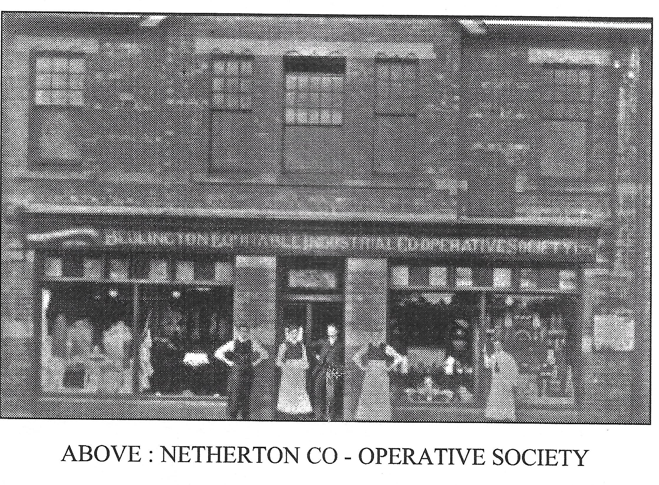
According to one of the "Bedlingtonshire Revisited" booklets, there was a branch of the Bedlington Coop at Netherton Colliery
-
1
-
-
On 31/01/2021 at 17:31, Alan Edgar (Eggy1948) said:
@James - do you have a book with that info in or is it online?
I was thinking of creating an Album - 'Doctor Pit and Rows' - where any member could add new entry and info.
In the 1980’s Stephen Martin wrote 7 booklets that together formed the “Bedlington Villages History Series” The titles are – Bedlington, Sleekburn, Stakeford & Bomarsund, West Sleekburn, Choppington, Barrington, Netherton. (Perhaps there is also one on Cambois?) Unfortunately I only have 3 of them – Bedlington, Netherton and “Bomarsund & Stakeford”
I think it is a good idea to open an album on the Doctor Pit and Rows. There have been lots of photos posted in the history forum over the years and it would great to see them in an album. I have quite a few so as soon as the album is open I will post them.
-
1
-
-
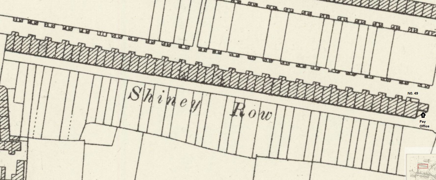
On 27/01/2021 at 20:49, Rigger said:
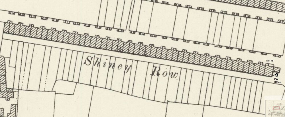
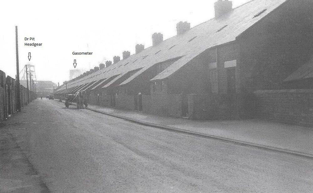
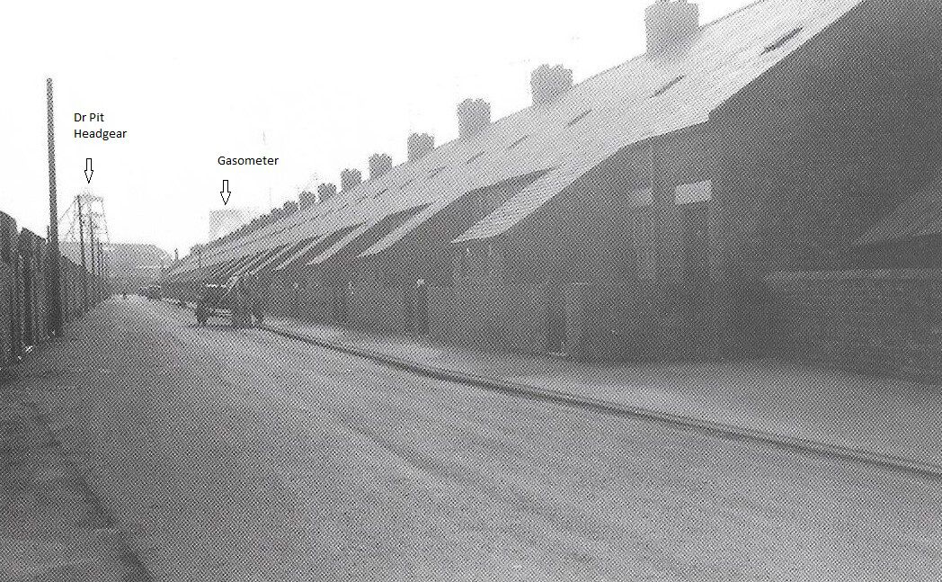
I have been informed Shiney Row was built by the Bedlington Coal Company about 1870. Have looked in the 1871 Census but can find no evidence people living there at that time. Does anyone know when they were first occupied? Also, can anyone advice where I can get a plan or drawing of one of the houses in Shiney Row which all had 3 bedrooms and a kitchen except number 49 which had 4 bedrooms and a kitchen. Thanks, Any help appreciated.
Probably the building work was not completed until after the 1871 census. Number 49 was bigger than the others because it was the undermanager’s house. In the 1911 census, Thomas Croudace, the Dr Pit undermanager was living there. His son, Charlie Croudace was the colliery manager for many years until 1955 when he was succeeded by George Hetherington. The pay office was built onto the gable end of No 49 where I received my first week’s pay of just over £4 in 1957.The building dates and number of houses of all the rows according to Stephen Martin’s book on Bedlington are as follows-
Cross Row. 12 houses built in 1855 to accommodate the shaft sinkers.
Shiney Row – 1870, 49 houses.
Doctor Terrace – 1874, 49 houses.
New South Row – 1886, 24 houses.
Telephone Row – 1886, 20 houses.
North Terrace - 1906, 50 houses.
A total of 204 families.
-
1
-
-
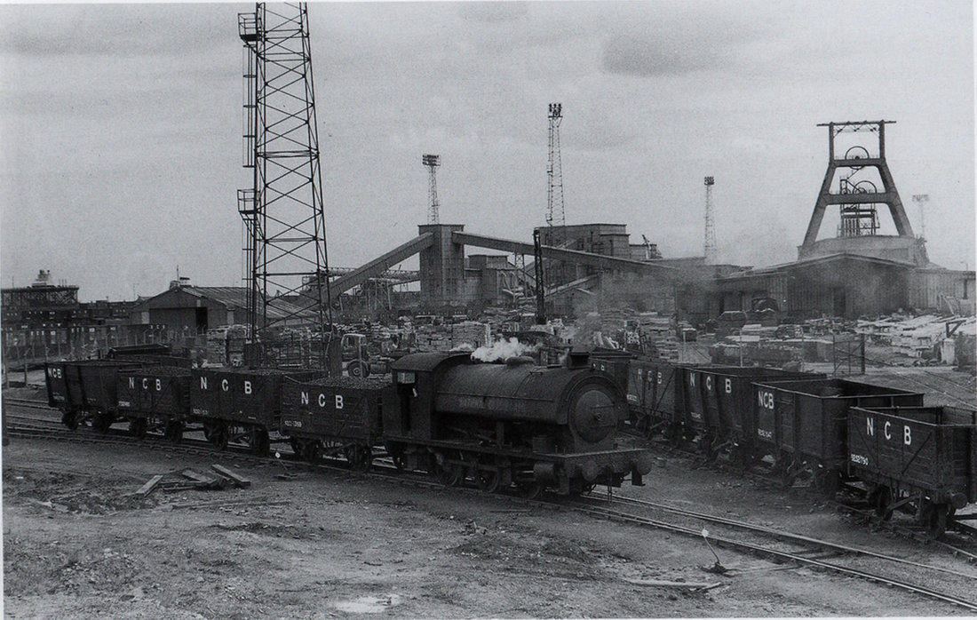
Bates Colliery behind the offices around the wash plant area taken late 1950's
-
1
-
-
On 03/05/2020 at 12:48, Alan Edgar (Eggy1948) said:
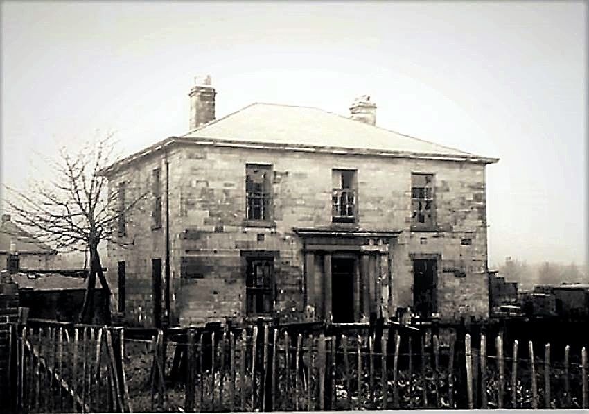
@Canny lass - @Ovalteeny might have download and saved some photos and info of Hollymount Hall from the Bedlington Facebook groups as his family lived there for a couple of years. This is the one photo of Hollymount Hall that I have downloaded.
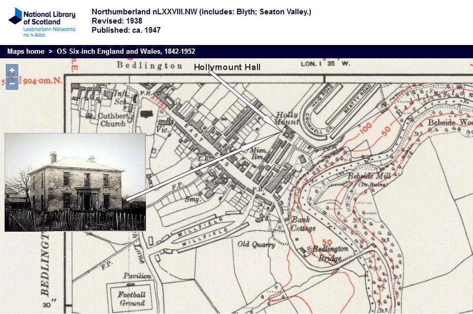
-
1
-
1
-
-
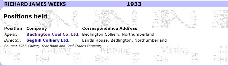
There were two members of the Weeks’ family that lived in Lairds house. The first was John George Weeks, born 1844 and his son Richard James Weeks, born 1884. Each of them held the position of Agent for the Bedlington Coal Company. (Information obtained from one of Evan Martin’s books and the Durham Mining Museum.)
The Bedlington Coal Company transformed Bedlingtonshire and there is no historical reference to the company anywhere that I have seen.
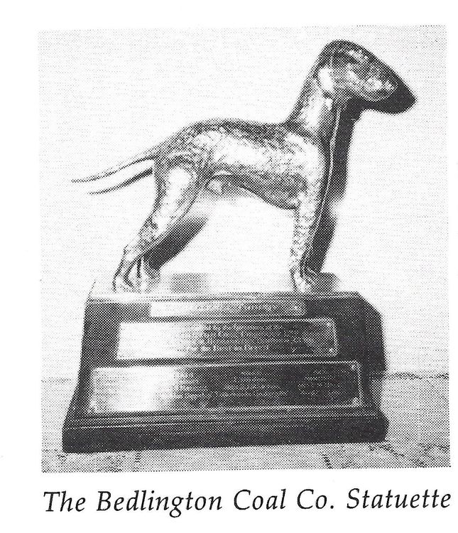
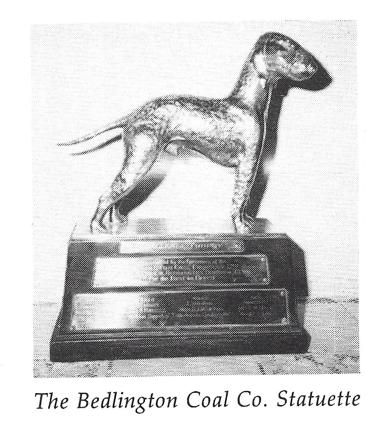
The Bedlington Coal Co. Ltd Challenge Cup, a solid silver model of a Bedlington Terrier was donated to the National Bedlington Terrier by Richard Weeks in 1936 and is still the top trophy presented at their annual Championship Show.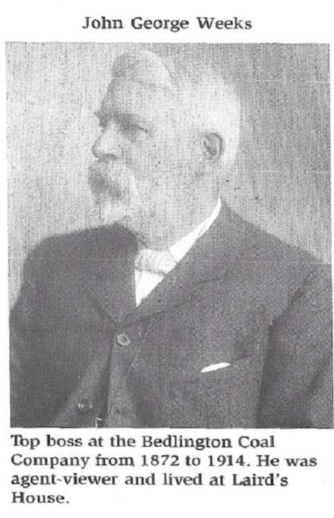
-
1
-


.jpg.8fc402b6ee049c4d947bb09b1ad9d082.jpg) You can see from this angle that there was quite a large extension to the hall not visible in the first photo.
You can see from this angle that there was quite a large extension to the hall not visible in the first photo.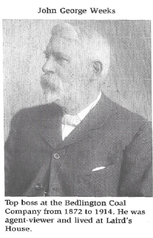
Small building at the end of Furnace Bridge?
in History Hollow
Posted
Canny Lass
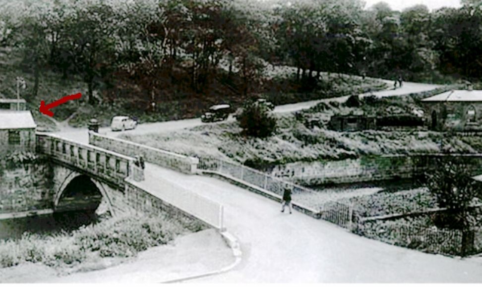
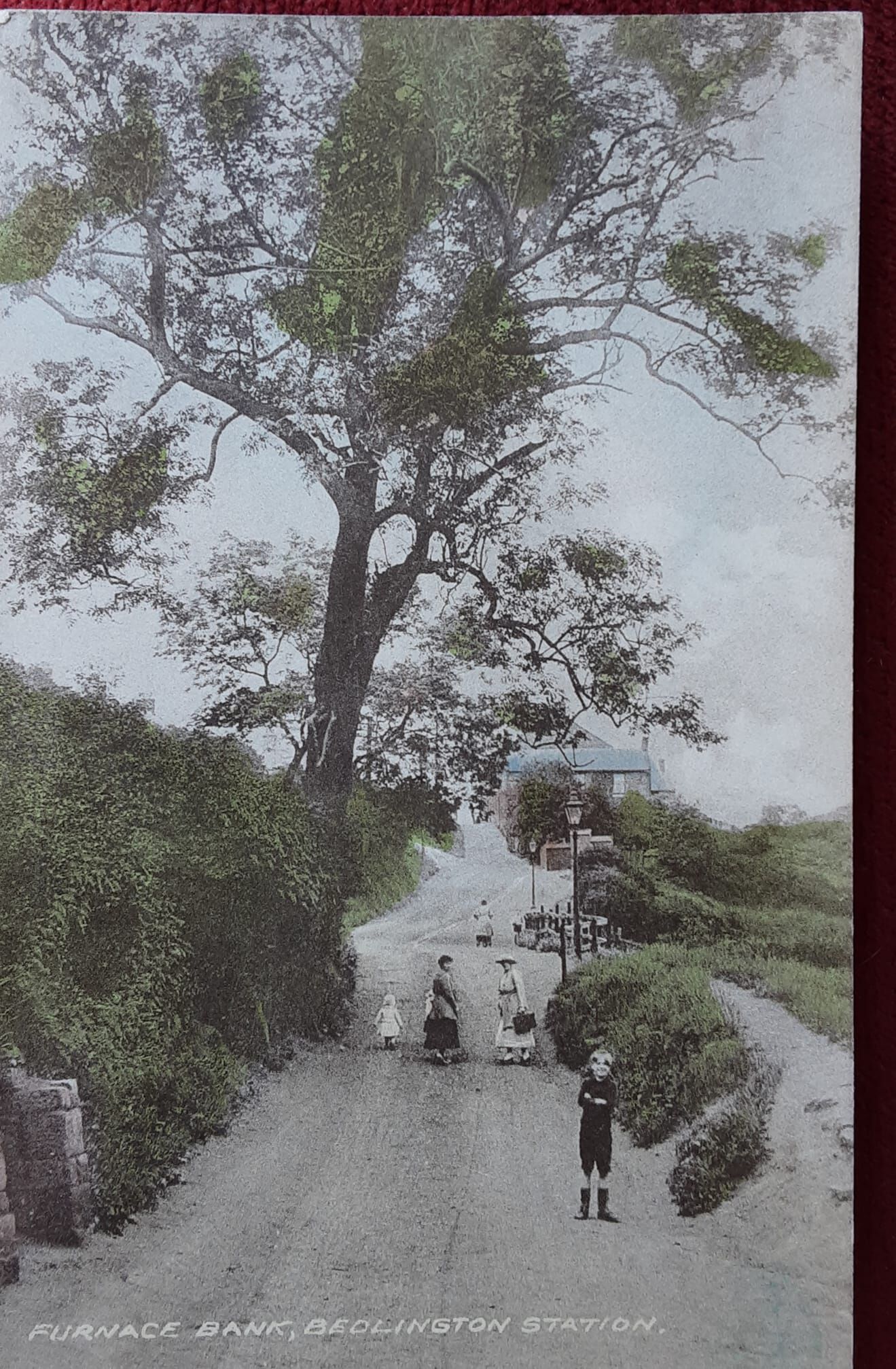
After seeing your message I searched a bit more to confirm my view that Rose Cottage and the Toll House was the same building and have to admit I was wrong! Toll Cottage was about 300 yards from Rose Cottage.
I looked at the 1939 census and it records the residents in Bebside wood (i.e. the Ha’penny wood); starting at Bedlington Bridge following the river through the woods down to Furnace Bridge.
It starts with Bridge Cottage, followed by Mill Cottage, Toll Cottage, Rose Cottage and Clock House. Bridge Cottage is the only building still there today. It is the house on the bend after crossing Bedlington Bridge on the way to Blyth. If you want to see the relevant page of the census search for Adam Gray, born 1 May 1908. Lived in: Toll Cottage, Bebside Woods, Blyth. To prove that I was completely wrong with my assumption, I came across the attached photo showing Rose Cottage in such a dilapidated state that it was beyond repair.
All the buildings in the census can be seen in the old map in the link show below. Toll Cottage is about 300 yards from the furnace bank entrance into Ha’penny woods.
I am not sure about copyright laws regarding the posting of information from Old Maps and the 1939 census. Anyone know if it is allowed?
https://maps.nls.uk/view/132267629