Contributor Leaderboard
-
4Points6,969Posts
-
.jpg.cdd7f8371d17e2f2f2e2a0e21e02f727.jpg) 2Points3,645Posts
2Points3,645Posts -
loopylou
New Members2Points48Posts

.thumb.jpg.7493ddab4a696108cf2b849323d3c155.jpg)

Popular Content
Showing content with the highest reputation on 09/01/26 in all areas
-
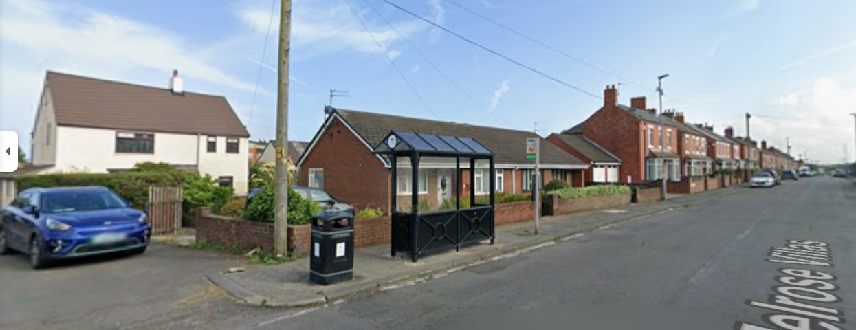
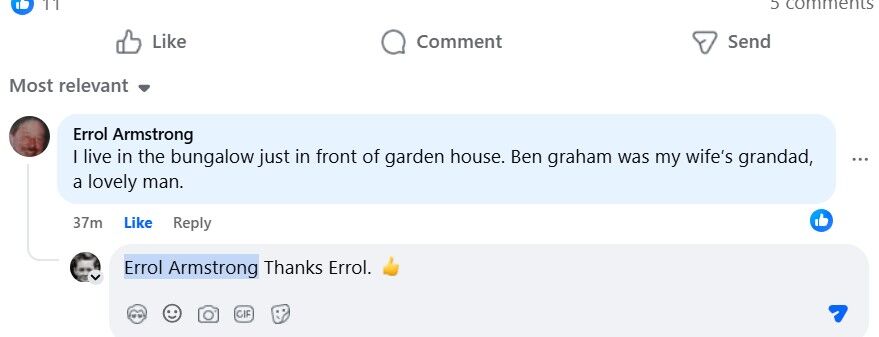
2 points@Canny lass & @Justine Matchett asked on the FB group Bygone Bedlington and don't know who lives in Garden House now but it is the white house in the images above and this comment from Errol Armstrong confirms it :-
 2 points
 -
1 point
 @loopylou would you like me to add numbers and sapce for info and names to your photo? At the moment I hve limited access to the software I need but hopefully I will be able to access it over this weekend.1 point
 -
1 point@Canny lass thank you very much, that must’ve took a while to do (and write)! I tried using the pub method before but certainly wasn’t as effective. Now it seems quite obvious- the west row would be west and the east row would be east… 😆1 point
-
1 point
-
1 point@Canny lass from the info you have posted above I think you could be right🤞 My clouded memory does recall that the white house used to be where a fella had a horse & cart and sold veg in the area but I hve no proof. I will put a post on the FB group Bygone Bedlington with the Google street view photo and a summary of your info and see if anyone comes up with any info thhat migth help1 point
-
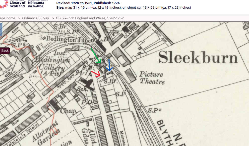
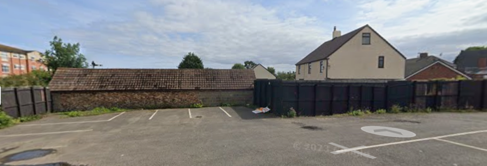
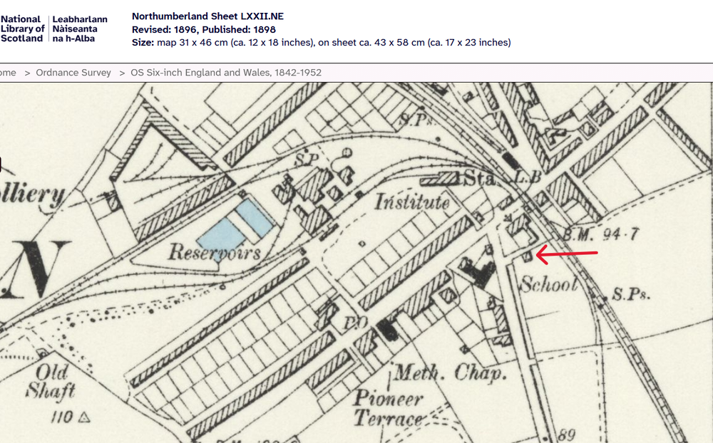
1 point@Alan Edgar (Eggy1948) @Justine MatchettLooking at those two photos, Alan, I think they show exactly the same buildings with Milburn House first on the left. I've had another think about the location and today I've compared OS maps with the enumerators route on the 1901 1911 and 1921 census returns and also the 1939 register. I'm now inclined to think that Garden House maybe still exists and could be the white house (albeit renovated or even rebuilt) immediately behind the bungalow adjacent to Milburn House. Looking at maps I can see that there has been a building on that spot, immediately behind the Railway Tavern (formerly Railway Hotel then Railway Inn) since the 1860s. Here's a map from 1898. I've arrowed the building in red: The map below is from 1924 (simply because it has the best detail). The Railway Inn I've arrowed green. What I believe to be garden House I've arrowed red, and I've arrowed an L-shaped building to its rear, on the same plot of land, which I'll come back to. Note that the present day bungalow isn't there. That corner where it stands appears to be land belonging to the house. The Railway Tavern is now demolished to make way for the new car park but the side street behind it, leading from the main road and giving access to the two buildings is still there. I had a little wander down that side street (with the help of Google) and I could clearly see that the L-shaped building is still there and seems to be very old. If William Graham, Benjamin's father, ran a carting business and later a market gardening business (at his home address, according to the 1921 census) then that would be the ideal place - maybe stables for horses when he was carting. The name Garden House, from 1911 when William was a carter, may well be a topographic name - referring to the fact that it was the only building there with a garden which faced the main street. making it easily identifiable. Look at the old maps and you'll see that all other buildings had a back yard and/or an allotment garden along the length of what is now Melrose Villas and Melrose Terrace. All in all, the census returns show that the Graham family have lived on the same spot between the Railway Tavern and, after its construction, Milburn House. From 1911 it had the address Garden House. On early maps this is the only house adjacent to the Railway Tavern. What do you think? Could this be Garden House? Anybody living in the area today who fancies knocking on the door and asking? I'd love to know.

 1 point
 -
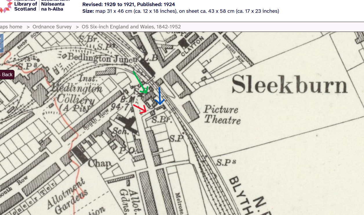
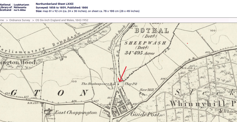
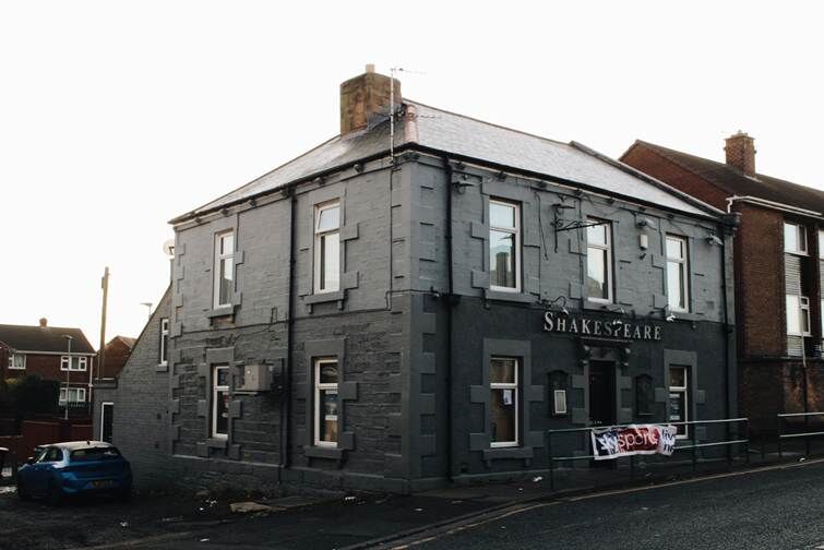
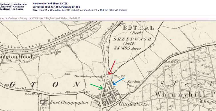
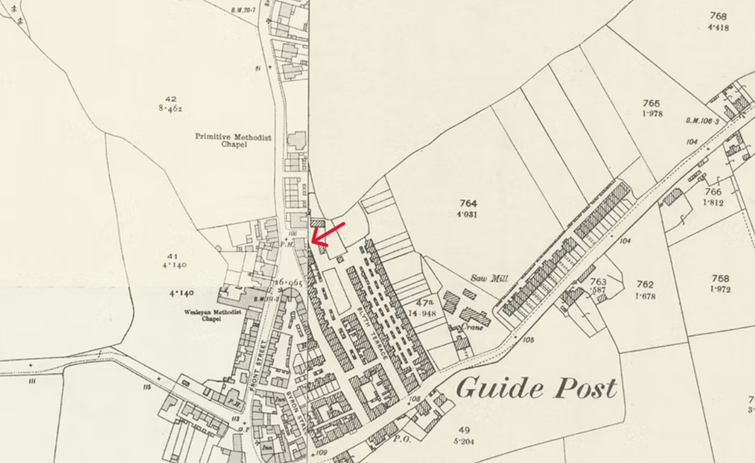
1 pointHi @loopylou Your turn to make a cuppa! Have you ever heard the saying ‘Cherchez l femme’ (literally, ‘look for the woman,) commonly used in detective fiction when solving mysteries? I have my own version ‘cherchez la pub’ (literally, ‘look for the public house’) which I use in detective reality to solve the mysteries of family-whereabouts. While streets and roads often change their names public houses very rarely do and when it does happen, it’s often to a spin-off from the old name. If your relative is John Storey (wife A, children: S A, E and J I) then it’s possible not only to find the street but possibly even the house. Just follow the enumerator on his route until you find both your relative and the nearest pub. Often the pub is still in existence today. Using my ‘cherchez la pub’ method, I followed the route of the enumerator, Mr George Thornton, in the 1871 census: Parliamentary Borough of Morpeth – Parish of Bedlington – Ecclesiastical district of Choppington, Enumeration district 10. George Thornton, describes his enumeration district as “Guide Post East, West, North & South. Choppington, Choppington New Colliery, Bothal Haugh, Sheepwash Bank, Sheepwash & Cleesewell Hill, Stakeford Gate & Cottage in the wood”. Following the census on the 3rd of April 1871 he starts his rounds at the Angler’s Arms (schedule nr 1) at the bottom of Sheepwash Bank and continues up the bank along what is today the A1068 to schedule numbers 2 – 5. These 4 dwellings, simply have the address “Sheepwash Bank” which is located in the “Hamlet of Sheepwash Bank”. From there he proceeds straight ahead to the “Village of Guide Post” where the 7 families resident at schedule numbers 6 - 12 simply have the address “Guide Post”. Still in the “Village of Guide Post” he continues along “Sheepwash West Street” and visits the 16 families living there (schedule nrs. 16 – 28). Moving on, he enters “Sheepwash - East Row” (schedule nrs. 29 – 57) and its 29 families. At schedule nr. 36 I find Thomas Marsden – hopefully the same person you mentioned in your previous post. At schedule nr 45 I find, what I believe to be your relatives, John Storey and family, and low and behold at schedule nr. 54 I find the first public house on George’s round. It’s called The Shakespeare– and here it is on a map from 1866! You’ll see that The Shakespeare is marked BH. This is because it was originally (1850s) a Beer House (marked BH on OS maps rather than PH, Public House). At that time, according to the North East Heritage Library, it was the most northern building in the Village of Guide Post. Being a beer house meant that it was only allowed to sell ale whereas a public house could sell anything. Because of this restriction it was much cheaper to obtain a licence for a beer house. Here is the ‘Shakespeare’ today. If you live in the area you’ll probably recognize it as being on Front Street in Guide Post though this is not the original building. So, where did John Storey live? Between John Storeys residence and The Shakespeare there were only 8 dwellings so my guess is that “Sheepwash West Street’ and “Sheepwash East Row,” both in the village of Guide Post” are the following - in which case John lived towards the northern end of “Sheepwash East Row” (possible West Street arrowed green, possible East Row arrowed blue) just a stone’s throw from the beer house. However, there is another option. East Row probably changed its name and if the above blue-arrowed row is East Row, then it was built out between 1866 and the 1890s filling the gap between the northern end of “Sheepwash East Row” and The Shakespeare. You can see this development in this compilation of 2 maps from the 1890s on the left and the 1920s on the right (The Shakespeare marked in red on the 1890s side and now a PH). If this development occurred between 1866 and 1871 when the census was completed, he would have lived in the new development. What about Thomas Marsden? A possible explanation for Guide Post vs. Scotland Gate may be a district boundary change. Just a thought! I hope this was of use to you and that you yourself might find a use for my ‘cherchez la pub’ method. If you want any of the documentation I've researched give me a shout.
 1 point