.jpg.cdd7f8371d17e2f2f2e2a0e21e02f727.jpg)
Canny lass
Supporting Members-
Posts
3,628 -
Joined
-
Last visited
-
Days Won
425
Canny lass last won the day on February 13
Canny lass had the most liked content!
Reputation
1,455 ExcellentAbout Canny lass
- Birthday 13/01/1947
Profile Information
-
Gender
Female
-
Location
Where ever I lay my (incandescent, purple) hat
Recent Profile Visitors
-
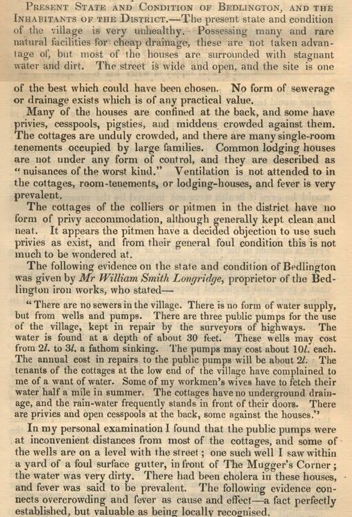
Found this little gem while rummaging for information on the whereabouts of the Bedlington Post Office, mid 19th century. It is a "Report to the General Board of Health for Morpeth re Cholera, dated 1849. It certainly makes me grateful and thankful for how Bedlington is today.
- 1 reply
-
- 1
-

-
@Nicola RileyHi Nicola, welcome to the forum. Sorry to hear about your mam's death. If I'm thinking of the right person then I went to school with Joyce - Westridge Secondary Modern 1959 - 1962. A very nice girl. She wasn't in my class but in the same class as my best friend so we hung about together during our breaks. You'll find a couple of school photos of that Joyce in the Gallery, Westridge album. Might be worth a look. I think you may have found the topic related to Fountain Yard where your nanna's brothers are mentioned. I don't think Fountain Yard comes up in any other topics. Dr Pit is up for discussion frequently. Type "Dr Pit" (inverted commas are important) in the search box, top right and you'll get a list of where it appears.
-
Nicola Riley started following Canny lass
-
.thumb.jpg.7493ddab4a696108cf2b849323d3c155.jpg)
The 'Market Place' Post Office journey.
Canny lass replied to Alan Edgar (Eggy1948)'s topic in History Hollow
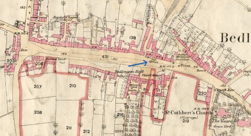
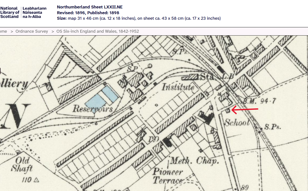
Sorry about that! Going further back, I found John Urwin in another trade directory, History, Topography, and Directory of Northumberland 1855 p. 897 and see that even then he was Bedlington’s Postmaster while at the same time running his chemist and druggist business. The question arises – did Urwin live in the same place? I looked him up in the 1851 census. The 1851 census doesn’t reveal so many household addresses. A couple of prominent buildings are named: Fountain Hall and the Vicarage. Apart from Sun Inn and the Red Lion Inn no pubs are named on Front Street. That doesn’t mean to say that pubs did not exist. The number of “Innkeepers”, “Beer-house keepers” and “Publicans registered in the town says otherwise. However, I could not find John Urwin living next door to any of them, suggesting that he may not always have lived next door to the Grapes Inn. Following the enumerator’s route from the Market Place towards the Red Lion I find at schedule nrs. 215 and 214 a “retired innkeeper” and an “innkeeper” next door to each other. Though not named as such, their proximity to the Market Place and the fact that they are neighbours leads me to believe that they are the Masons Arms and the Grapes Inn. Continuing westwards and 28 dwellings later (presumably located both on Front Street and in the various yards) I find John Urwin at schedule nr 203. Moving on, past another 16 dwellings I find the last dwelling of West End, on the corner of Glebe Row, at sch. Nr. 187. It seems to me therefore that John Urwin is living nearer the Red Lion than the Market Place and this location could therefore possibly be Baptist Yard. John Urwin was not a local lad, having been born in Lanchester, Durham. When he moved to Bedlington I can't say but as he was, with certainty, the postmaster, at least between 1855 and 1858 he must have held that position when the telegraph system was installed but I haven't been able to establish at which address. The OS map of 1860shows a Post Office situated between the Grapes Inn and the Mason’s Arms at the lower end of Front Street West. As maps require a few years of research and survey work prior to publication, it’s fair to assume that Urwin may have lived and worked here in 1858 in his capacity as Postmaster. If this is the case then the telegraph system could have been installed here, rather than in Baptist Yard. Its installation could well have been the reason for his move. A bit more work required yet. -
.thumb.jpg.7493ddab4a696108cf2b849323d3c155.jpg)
The 'Market Place' Post Office journey.
Canny lass replied to Alan Edgar (Eggy1948)'s topic in History Hollow
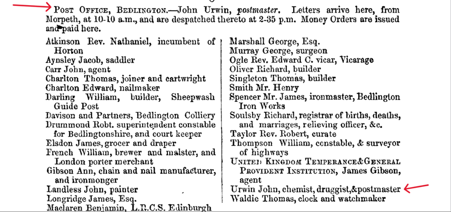
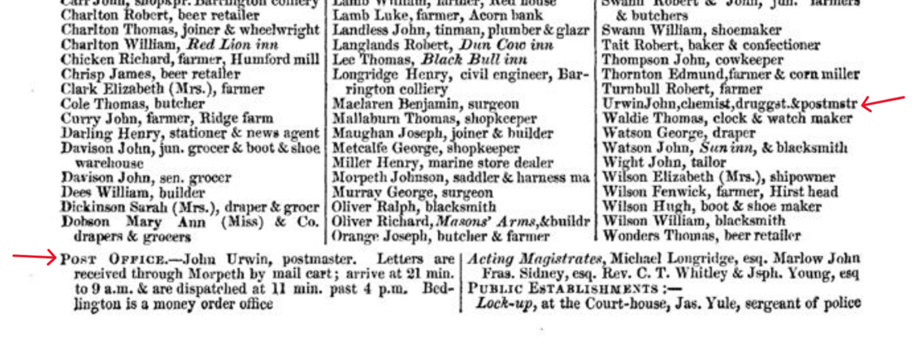
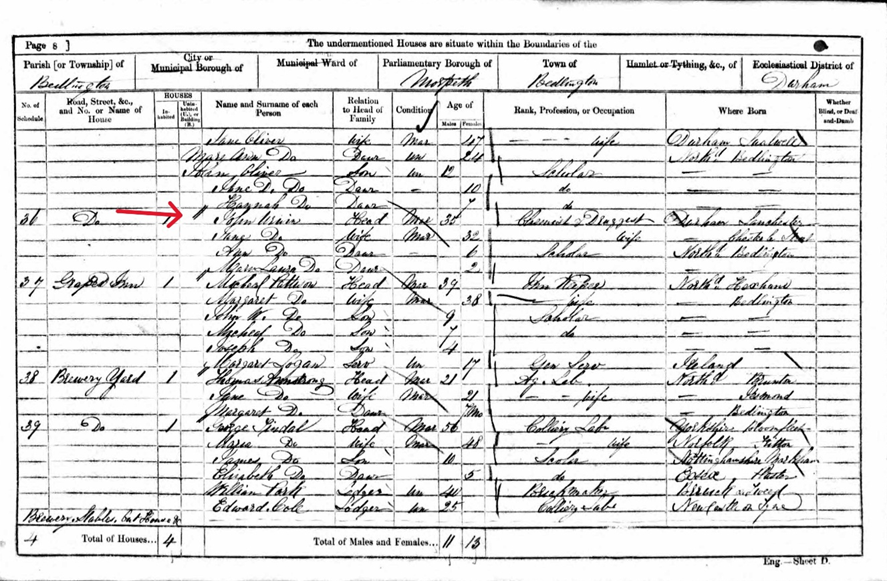
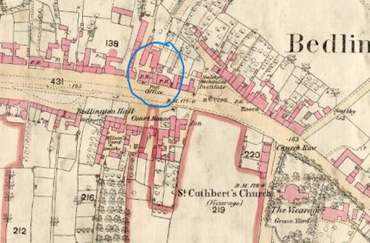
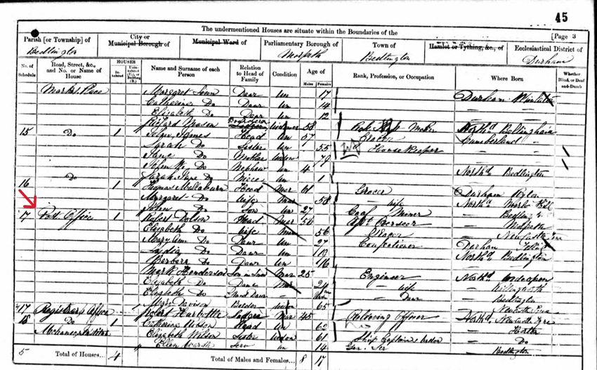
The many comprehensive trade and residential directories are a great source of information covering such things as businesses, notable residents, tradespeople and local institutions - of which the Post Office is but one - so I spent yesterday (and a fair bit of today) rummaging through those I have access to and I thought a fair place to start would be the 1858 Post Office Directory of Northumberland (later called Kelly’s Directory). Part of the entry for Bedlington, p. 26, looks like this: Bottom left I can see that Bedlington did indeed have a “Post Office”. The Postmaster was John Urwin and letters were received by him, from Morpeth, by mail cart. Middle right we can see that John Urwin was a man of many talents when, under the businesses section, he appears as chemist, druggist and postmaster. I thought that was odd but further rummaging through the GPO and Post Office Museum sites shows that it was more than common to combine the role of ‘Postmaster’ with another profession. It seems that by the 1850s the postal system was so well developed that “no village, however insignificant” was “without its receiving-house”. By 1855 there was a network of almost 10, 500 post offices across the country “(made up of 920 Head Post Offices and 9,578 Sub-Post Offices and Receiving Offices)”. There were, in other words, several types of ‘Post Office’, whereof the receiving house had least responsibility. For them, it sufficed to receive letters from the Head Post Office and display them in a window so that anyone passing could see if they had mail to collect. The Postal Museum (online) describes the role of the Postmaster as “a salaried male official in charge of PO operations and staff within a specific area defined by its Post Town”. The term Postmaster, they add “was often used colloquially to refer to a Sub-Postmaster. Most Sub Postmasters and Sub Postmistresses were not employed by the Post Office. They had a main business, like a shop, which offered Post Office services”. Those who took on this role were often considered central, trusted figures in their community. That explains a lot! To me it seems that John Urwin was a sub-postmaster and, looking quickly through several other small towns in the directories, the terms ‘Postmaster’ and ‘Post Office’ are used fleetingly for what appear to be Sub-Postmasters and Sub-Post Offices – having mail delivered to them once a day from a Head Post Office by whatever means available. In 1830 mail was distributed by train for the first time and when Morpeth got its station, in 1847 (on the London to Edinburgh line), it appears to have become the location of the Head Post Office for quite a large area, including Bedlington, to which it distributed mail for further distribution or, more commonly, for collection. Next, I looked at the nearest census returns (1861) to see where John Urwin lived: There he is, schedule nr 36, right next door to the Grapes Inn. His neighbour on the other side, at schedule nr 35, is the Masons Arms: That all fits in nicely with what we can see on the 1860 OS map below. I can also mention here that the Post Office can be seen to have opened in the Market Place (Sch.nr 17). It is occupied by Robert Dobson who gives his occupation as “Ass’t. Overseer” rather than any sort of Post Office worker. Perhaps this dwelling is above the Post Office. I'll take a break here as one of the grandchildren has just arrived. I'll try to post the rest later. -
.thumb.jpg.7493ddab4a696108cf2b849323d3c155.jpg)
The 'Market Place' Post Office journey.
Canny lass replied to Alan Edgar (Eggy1948)'s topic in History Hollow
I doubt if the Sleekurn edition would cover Front Street, West End, Alan. I don't have any of Stephen B Martin's books but I have several by Evan Martin - including the one above, posted by Vic. Evan Martin uses the same photo of 'Baptists Yard' accompanied by almost the same text. Unfortunately he doesn't disclose the source of the photo or the information in the text. He does say that the "The Baptist Yard" contained " Bedlington's first Post Office and in 1858 the telegraph system was installed there." (page 99). I find it somewhat strange that just 2 years after such an investment, the Post Office would move to new premises nearer the Market Place as shown on the 1860 map. It's also worth remembering that maps aren't created overnight. They take several years of survey work before being published, so the location of the PO shown on that map may well have been surveyed prior to 1860. I have to admit that I have wondered if that really is Baptist Yard and if the PO was ever located there. -
.thumb.jpg.7493ddab4a696108cf2b849323d3c155.jpg)
The 'Market Place' Post Office journey.
Canny lass replied to Alan Edgar (Eggy1948)'s topic in History Hollow
That is interesting! I would love to see it confirmed somewhere. Does Martin give any reference to the source of that information? Perhaps the booklet contains a list of references to literature, maps etc. used by him when compiling the booklet. If so, could you post a copy here please. -
.thumb.jpg.7493ddab4a696108cf2b849323d3c155.jpg)
The 'Market Place' Post Office journey.
Canny lass replied to Alan Edgar (Eggy1948)'s topic in History Hollow
Mild Cognitive Impairment? Never heard of it! I call that sort of thing ”having a senior moment” - mind you, I’ve been having them frequently since I was 30! -
.thumb.jpg.7493ddab4a696108cf2b849323d3c155.jpg)
The 'Market Place' Post Office journey.
Canny lass replied to Alan Edgar (Eggy1948)'s topic in History Hollow
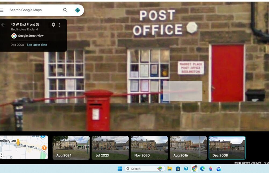
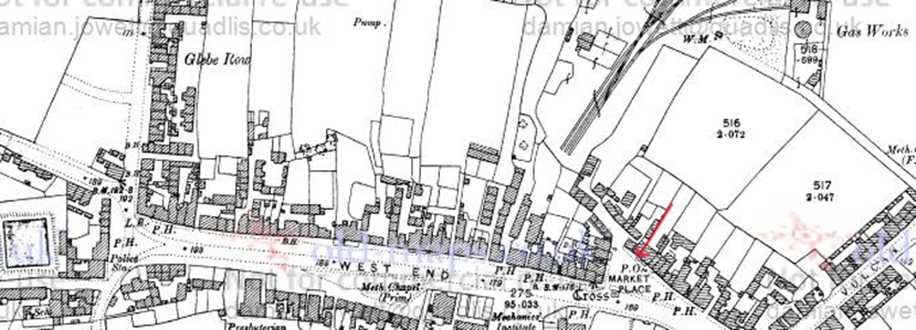
I'm afraid I have to disagree with you there, Alan. I think this is Front Street West, Alan – same building you show in your second photo. The Bedlington PO has a long history and it first appeared on OS maps about the time the postal service was being developed. The first PO in Bedlington was also on Front Street West but nearer to the Market Place than to the Red Lion as you will be able to see on the 1860 OS map below: In 1897 the PO began to appear in the Market Place on the OS map of that year shown below: It remains in that location on those maps I’ve looked at until at least 1967 (Copyright prevents me looking at anything more recent) and I can remember using it then. It later moved from the Market Place, as you rightly say, but I have no recollection of it moving to Front Street East and I can’t remember any buildings on Front Street East with a low wall in front as can be seen in your photos. I returned to Bedlington in the 80s for a while and the PO was then located on Front Street West but further up the street towards the top end (Red Lion). It had a small walled area in front. I’m pretty sure that’s it in your photo which I’ve reproduced above. -
Thank you! Nice to know you enjoyed it. They were an important family in Bedlington's history so I thought they were worth a bit of effort. My own family history research is at a bit of a standstill so I have some time over from that and I might as well put it to good use.
- 20 replies
-
- 1
-

-
- furnace
- vulcan place
-
(and 2 more)
Tagged with:
-
.thumb.jpg.7493ddab4a696108cf2b849323d3c155.jpg)
Back Clayton Street, Bedlington Station
Canny lass replied to Alan Edgar (Eggy1948)'s topic in History Hollow
The 6 inch maps show only the 'footprint' of the building. If you want more detail it's always worth having a look at the 25 inch. Size really does matter!! PS Sorry, that should say 1881 NOT 1901. -
.thumb.jpg.7493ddab4a696108cf2b849323d3c155.jpg)
Back Clayton Street, Bedlington Station
Canny lass replied to Alan Edgar (Eggy1948)'s topic in History Hollow
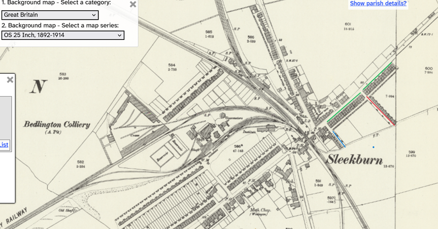
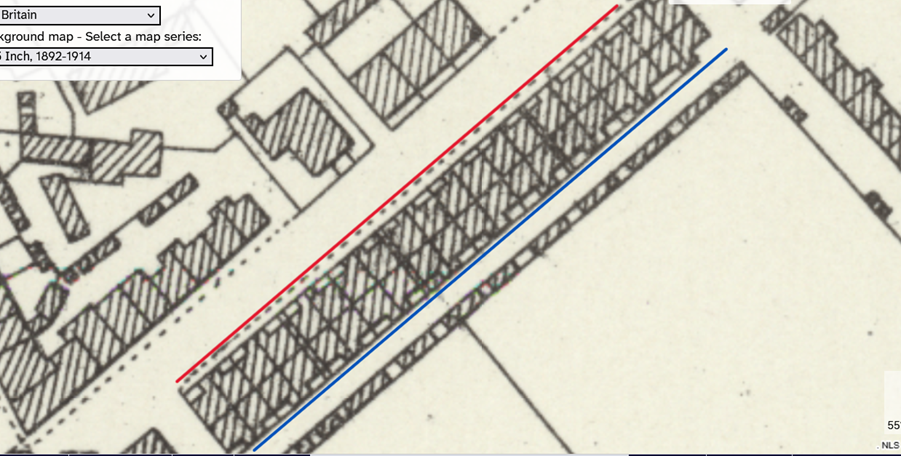
The photo shows Front Clayton Street with the spire of St Johns in the distance. Back Clayton Street was, in fact, the same row of back-to-back houses entered from the rear of the buildings. No need to check the census, Alan, I’ve ‘wandered’ up and down Clayton Street many times on maps and census returns as I’ve had relatives living in both Front Clayton Street and Back Clayton Street in 1911. In 1901 these streets were called First Street and Second Street. Both streets were comprised of 36 two-roomed dwellings that housed mostly miners. They appear to have been extremely overcrowded with many housing 9-10 people – of which a couple could be lodgers! Imagine the sleeping arrangements!! The map below shows the houses on Clayton Street (green) built in two blocks of back-to-back houses. The first block with 40 dwellings, was located between Pheonix Street (blue) and the entrance to Cross Street (red). The second, with 32 dwellings, was located between the entrance to Cross Street and North View (Not shown on this map). Here’s a zoomed view of the first block nrs. 1 - 20 Front Clayton Street (red) and 1 – 20 Back Clayton Street (blue). Nrs 1 and 2 Back Clayton Street was a “Bake House” and did not house a family in 1911. From the photo, it appears that nrs. 1 and 2 Front Clayton Street have also been some sort of business premises. You can clearly see the back-to-back style of building with entrances on both sides of the block. I’ve often wondered how the toilet facilities worked. As you see, these are facing Back Clayton Street. However, there appears to be some sort of passage way connecting front and back every 8 – 12 dwellings. Must have been a nightmare for the residents of Front Clayton Street on cold winter’s morning. -
Happy to have been able to help.
-
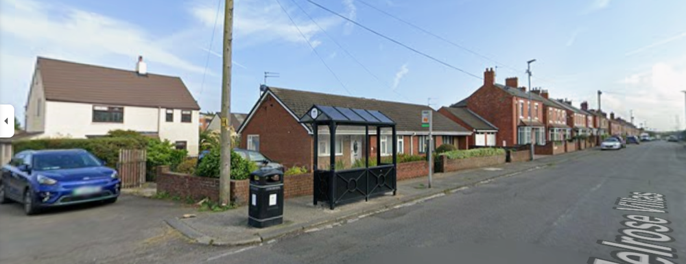
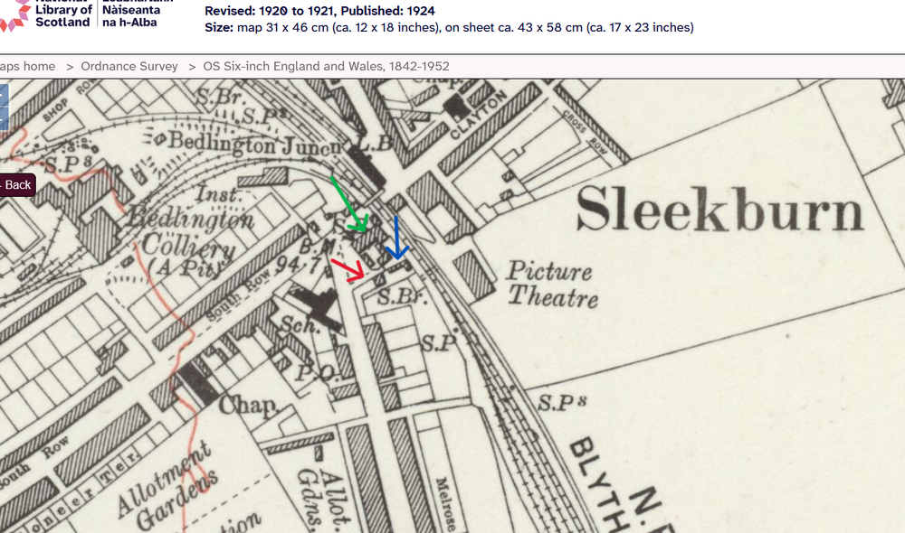
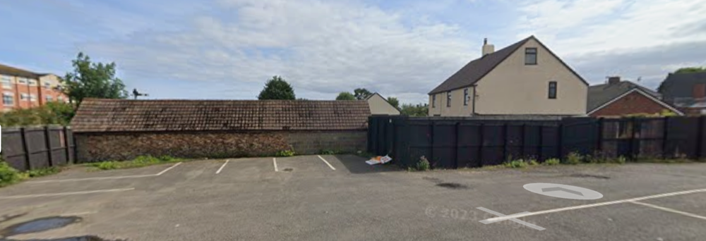
@Alan Edgar (Eggy1948) @Justine MatchettLooking at those two photos, Alan, I think they show exactly the same buildings with Milburn House first on the left. I've had another think about the location and today I've compared OS maps with the enumerators route on the 1901 1911 and 1921 census returns and also the 1939 register. I'm now inclined to think that Garden House maybe still exists and could be the white house (albeit renovated or even rebuilt) immediately behind the bungalow adjacent to Milburn House. Looking at maps I can see that there has been a building on that spot, immediately behind the Railway Tavern (formerly Railway Hotel then Railway Inn) since the 1860s. Here's a map from 1898. I've arrowed the building in red: The map below is from 1924 (simply because it has the best detail). The Railway Inn I've arrowed green. What I believe to be garden House I've arrowed red, and I've arrowed an L-shaped building to its rear, on the same plot of land, which I'll come back to. Note that the present day bungalow isn't there. That corner where it stands appears to be land belonging to the house. The Railway Tavern is now demolished to make way for the new car park but the side street behind it, leading from the main road and giving access to the two buildings is still there. I had a little wander down that side street (with the help of Google) and I could clearly see that the L-shaped building is still there and seems to be very old. If William Graham, Benjamin's father, ran a carting business and later a market gardening business (at his home address, according to the 1921 census) then that would be the ideal place - maybe stables for horses when he was carting. The name Garden House, from 1911 when William was a carter, may well be a topographic name - referring to the fact that it was the only building there with a garden which faced the main street. making it easily identifiable. Look at the old maps and you'll see that all other buildings had a back yard and/or an allotment garden along the length of what is now Melrose Villas and Melrose Terrace. All in all, the census returns show that the Graham family have lived on the same spot between the Railway Tavern and, after its construction, Milburn House. From 1911 it had the address Garden House. On early maps this is the only house adjacent to the Railway Tavern. What do you think? Could this be Garden House? Anybody living in the area today who fancies knocking on the door and asking? I'd love to know.
-
Hi again Justine, for the Graham family I have census records 1911, 1921 and 1939 (the pre-war register). For Minnie, I have census records 1921 and , I believe, 1939. I also have a birth index for Minnie which would enable you to obtain a copy of her birth certificate. I'll send them to your inbox (the envelope top right of screen).
-
Thanks Alan! I hadn't seen Rothley Shield. Bernicia is also still there but now has a wall plaque to the right of the door.




.png.cebf74415d732db3597b307df7a12728.png)