.jpg.cdd7f8371d17e2f2f2e2a0e21e02f727.jpg)
.jpg.a8059e59bff91bf6691d0bfedf8fad60.jpg)
Canny lass
-
Posts
3,639 -
Joined
-
Last visited
-
Days Won
433
3 Followers

Recent Profile Visitors
74,170 profile views


-
.thumb.jpg.7493ddab4a696108cf2b849323d3c155.jpg)
East Bedlington Parish Council - Civic Awards 2026
Canny lass replied to Alan Edgar (Eggy1948)'s topic in Talk of the Town
What a great idea! -
Well done!
-
In my experience of family history research I've found people's ages to be the absolute least reliable when it comes to determining a date of birth! When the census started in 1841 children's ages up to and including 14 years were recorded accurately. Anybody 15 years and over had their age rounded up or down to the nearest 5 or 10. This practice was stopped for the 1851 and subsequent census surveys but I've found examples in my family of enumerators who continued. Going back to the 1800s quite a lot of people didn't even know their birthday. You are right when you say that parental consent for under 21s was required in 1866 but the legal minimum age for marriage was 14 for males and 12 for females. However, William would be well over the age of 21 so he wouldn't be needing any consent and wouldn't need to lie. The 1841 Scotland census isn't available to me in its original form but a transcription gives William's age as 7 "mo". That census was done 6-7 June so this would give a birth date between 6th October and 6th November the previous year – 1840. This would fit in nicely with the birth date of William Taylor, registered in Meigle, Perthshire, as 25 OCT 1840 to James Taylor and his wife Jess (nee Walker). That might be worth investigating further. Do you know that children in the 1800s were very often named in a certain order? I had a look at William and Elizabeth's children: 1st son is given his maternal grandfather's name. (Robert) 1st daughter is given her paternal grandmother's name. (Jess) 2nd son is given his paternal grandfather's name. (James) 2nd daughter is given her maternal grandmothers name. (Jessie) As both grandmothers shared a similar name Jess/Jessie the 2nd daughter would possibly be given her mother's name - Elizabeth. Carry on with the detective work!
-
Well there you go! Whining and whinging aren't always a bad thing and I'm sure you did both beautifully, Malcolm. Well done, I'm sure this will be a real asset to Bedlington and I'm looking forward to visiting it.
-
Good Luck! Let is know how you get on.
-
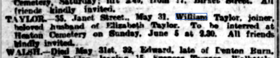
Hi again @Dave Taylor. It's not from the Death Index but at least you can know where he died and where he's buried and it gives you a date to work with in your research. It appeared in the Newcastle Evening Chronicle, Thursday 2nd June 1910 and was repeated in the same newspaper Saturday 4th June 1910. In case you might want to investigate further: Heaton Cemetery is now called Byker and Heaton Cemetery.
-
@Dave Taylor Hi Dave, welcome to the forum. If William's wife was Elizabeth, born Newcastle and living in 1911 in Shieldfield (Canada Street), Newcastle with 2 of her sons, John and George, then I think you're in the wrong area with Brick Lane. Elizabeth is living in Newcastle and, while it's not impossible, it seems unlikely that she would move back with the boys so soon after her husbands death as the boys would have had jobs to go to in Bedlington if they had been living there. Another reason not to move would be that William would be buried in Bedlington (or Bebside which was nearer Brick Road) but still part of Bedlingtonshire. That would be a hard thing to do for a widow. There is a William Taylor, born abt 1842 who's death was registered in Newcastle in December 1909 and that might well be worth having a look at: Name: William Taylor Age: 67 Estimated Birth Year: abt 1842 [abt 1842] Registration Quarter: Oct-Nov-Dec Registration Place: Newcastle upon Tyne, Northumberland, UK Death Date: Dec 1909 Inferred Death Place: Northumberland, United Kingdom Volume:10b Page: 56 Hope this helps. Let me know how you get on with your search and if I can be of any more help.
-
Westridge 1962 MrCook's Class.jpg
Canny lass commented on Alan Edgar (Eggy1948)'s gallery image in Historic Bedlington
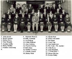 @Nicola Riley So pleased that you found her! A little correction: The photo doesn't show a PE class. Miss McLean (Later Mrs McDonald) was a PE teacher but this is a class photo for which Nancy (Miss McLean) was the form mistress. All classes had a form teacher. The class would go to her directly after assembly in the morning and she would fill in the attendance register before the pupils went to their first lesson. As Miss McLean was the only teacher of PE for girls then Joyce would certainly have gone to her PE classes.
 -
Netherton Colliery infants c1952 named.jpg
Canny lass commented on Alan Edgar (Eggy1948)'s gallery image in Historic Bedlington
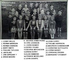 That’s the James Appleby that I remember! Nr 7 back row right.
 -
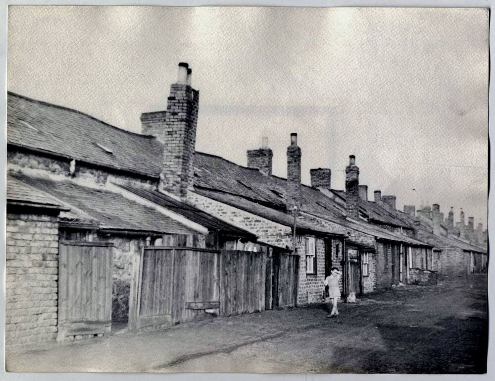
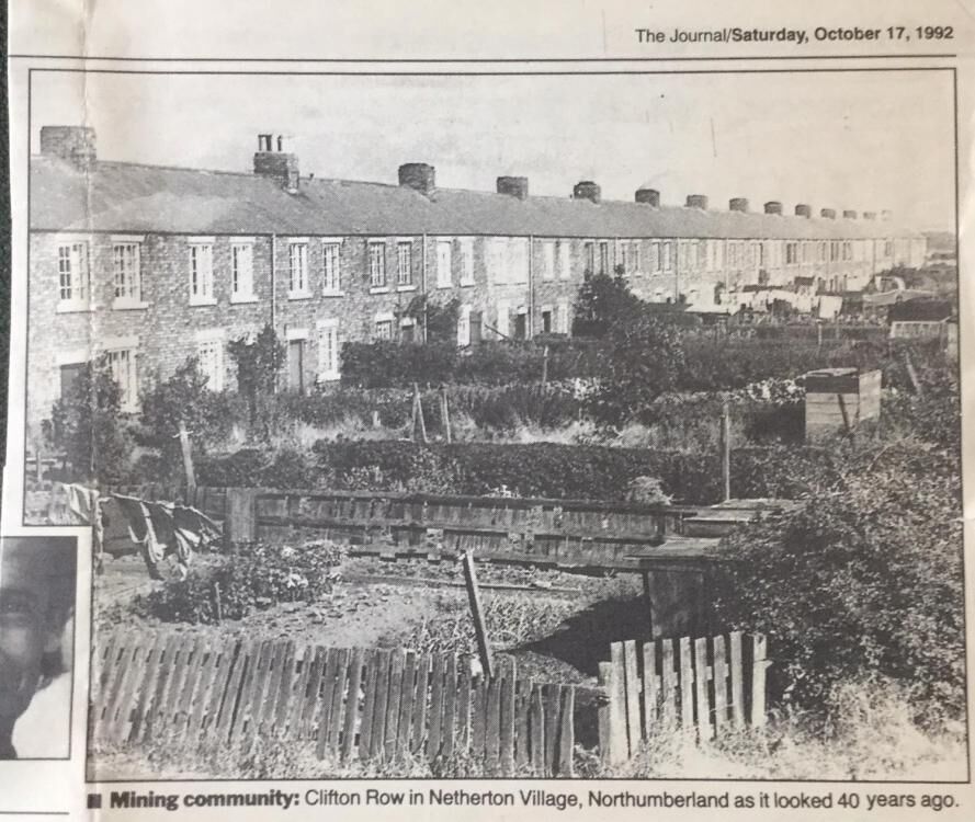
Welcome to the forum @Appleby I was born in Howard Row, which was next to Clifton Row. Howard Row was demolished shortly after my birth in 1947 but Clifton Row remained throughout my childhood and I played there often with classmates in the 50s. There were Applebys in Clifton Row then but I'm afraid I can't remember anything about them. I attended the colliery school which had 2 classes. There was a boy named Appleby there but not in my class, so he would be a year or so older/younger than me. I think his name was James. Alan recommended that you look in the gallery among the photos in the album Netherton/Nedderton old photos. I'm going to suggest that you also look in another album " Netherton/Nedderton old photos 2. There you'll find quite a few class photos for both the Netherton school (infants) and the Nedderton school (juniors) where all colliery kids were educated. With a bit of luck your friend might be able to recognise some family facial feature that could help to identify an Appleby. In that album you'll also find 2 of my favourite photos: Clifton Row, back (facing the outside 'netties' )and the more presentable Clifton Row, front facing the gardens.
-
No recollection whatsoever of reading it earlier! Clearly another of my 'senior moments'.
-
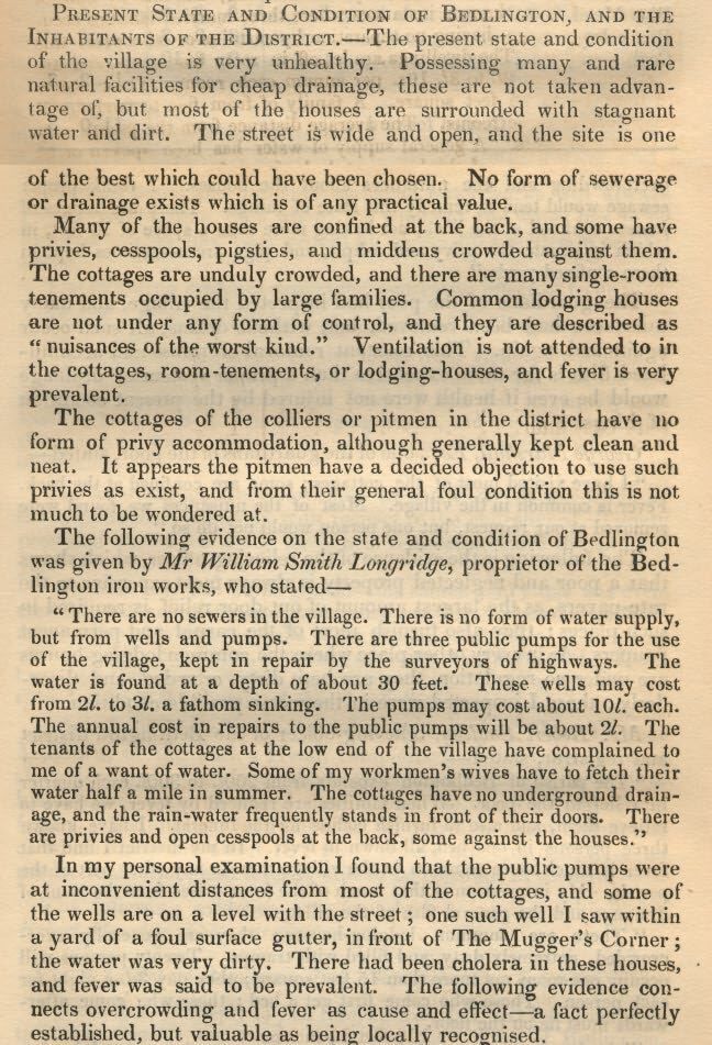
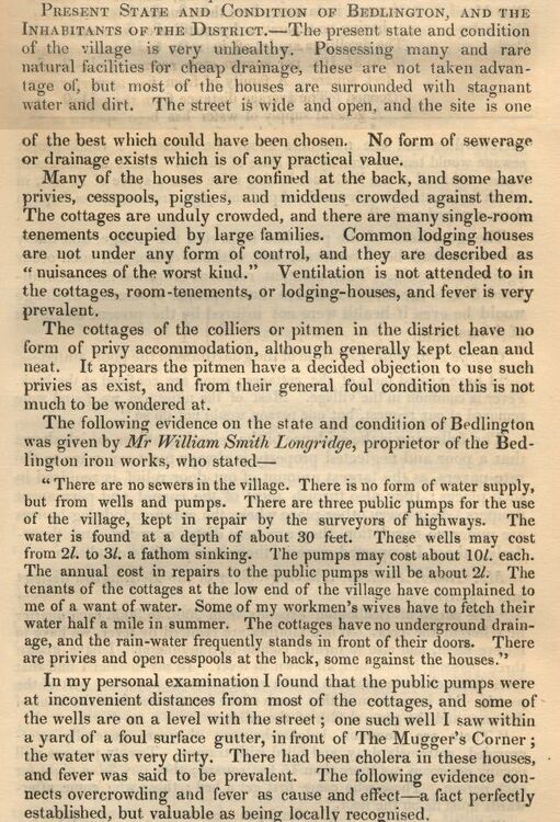
Found this little gem while rummaging for information on the whereabouts of the Bedlington Post Office, mid 19th century. It is a "Report to the General Board of Health for Morpeth re Cholera, dated 1849. It certainly makes me grateful and thankful for how Bedlington is today.
-
@Nicola RileyHi Nicola, welcome to the forum. Sorry to hear about your mam's death. If I'm thinking of the right person then I went to school with Joyce - Westridge Secondary Modern 1959 - 1962. A very nice girl. She wasn't in my class but in the same class as my best friend so we hung about together during our breaks. You'll find a couple of school photos of that Joyce in the Gallery, Westridge album. Might be worth a look. I think you may have found the topic related to Fountain Yard where your nanna's brothers are mentioned. I don't think Fountain Yard comes up in any other topics. Dr Pit is up for discussion frequently. Type "Dr Pit" (inverted commas are important) in the search box, top right and you'll get a list of where it appears.
-
The 'Market Place' Post Office journey.
Canny lass replied to Alan Edgar (Eggy1948)'s topic in History Hollow
Sorry about that! Going further back, I found John Urwin in another trade directory, History, Topography, and Directory of Northumberland 1855 p. 897 and see that even then he was Bedlington’s Postmaster while at the same time running his chemist and druggist business. The question arises – did Urwin live in the same place? I looked him up in the 1851 census. The 1851 census doesn’t reveal so many household addresses. A couple of prominent buildings are named: Fountain Hall and the Vicarage. Apart from Sun Inn and the Red Lion Inn no pubs are named on Front Street. That doesn’t mean to say that pubs did not exist. The number of “Innkeepers”, “Beer-house keepers” and “Publicans registered in the town says otherwise. However, I could not find John Urwin living next door to any of them, suggesting that he may not always have lived next door to the Grapes Inn. Following the enumerator’s route from the Market Place towards the Red Lion I find at schedule nrs. 215 and 214 a “retired innkeeper” and an “innkeeper” next door to each other. Though not named as such, their proximity to the Market Place and the fact that they are neighbours leads me to believe that they are the Masons Arms and the Grapes Inn. Continuing westwards and 28 dwellings later (presumably located both on Front Street and in the various yards) I find John Urwin at schedule nr 203. Moving on, past another 16 dwellings I find the last dwelling of West End, on the corner of Glebe Row, at sch. Nr. 187. It seems to me therefore that John Urwin is living nearer the Red Lion than the Market Place and this location could therefore possibly be Baptist Yard. John Urwin was not a local lad, having been born in Lanchester, Durham. When he moved to Bedlington I can't say but as he was, with certainty, the postmaster, at least between 1855 and 1858 he must have held that position when the telegraph system was installed but I haven't been able to establish at which address. The OS map of 1860shows a Post Office situated between the Grapes Inn and the Mason’s Arms at the lower end of Front Street West. As maps require a few years of research and survey work prior to publication, it’s fair to assume that Urwin may have lived and worked here in 1858 in his capacity as Postmaster. If this is the case then the telegraph system could have been installed here, rather than in Baptist Yard. Its installation could well have been the reason for his move. A bit more work required yet.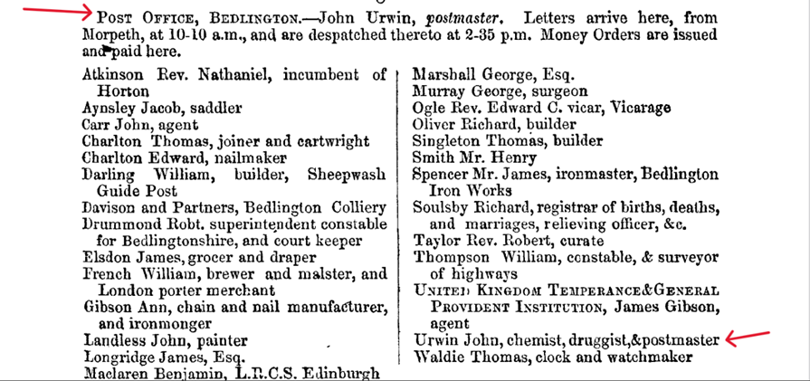
-
The 'Market Place' Post Office journey.
Canny lass replied to Alan Edgar (Eggy1948)'s topic in History Hollow
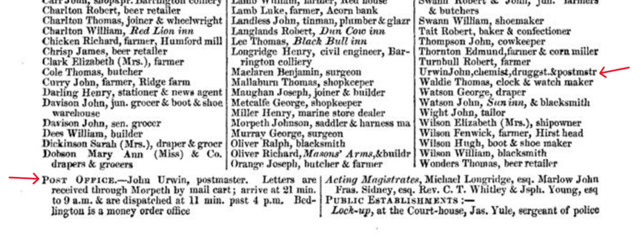
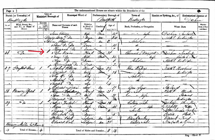
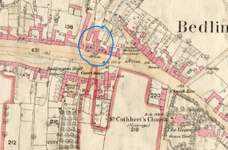
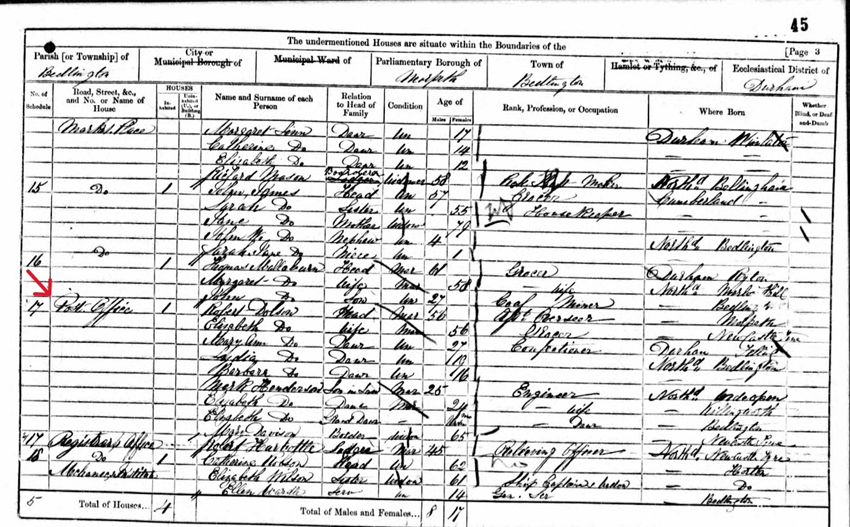
The many comprehensive trade and residential directories are a great source of information covering such things as businesses, notable residents, tradespeople and local institutions - of which the Post Office is but one - so I spent yesterday (and a fair bit of today) rummaging through those I have access to and I thought a fair place to start would be the 1858 Post Office Directory of Northumberland (later called Kelly’s Directory). Part of the entry for Bedlington, p. 26, looks like this: Bottom left I can see that Bedlington did indeed have a “Post Office”. The Postmaster was John Urwin and letters were received by him, from Morpeth, by mail cart. Middle right we can see that John Urwin was a man of many talents when, under the businesses section, he appears as chemist, druggist and postmaster. I thought that was odd but further rummaging through the GPO and Post Office Museum sites shows that it was more than common to combine the role of ‘Postmaster’ with another profession. It seems that by the 1850s the postal system was so well developed that “no village, however insignificant” was “without its receiving-house”. By 1855 there was a network of almost 10, 500 post offices across the country “(made up of 920 Head Post Offices and 9,578 Sub-Post Offices and Receiving Offices)”. There were, in other words, several types of ‘Post Office’, whereof the receiving house had least responsibility. For them, it sufficed to receive letters from the Head Post Office and display them in a window so that anyone passing could see if they had mail to collect. The Postal Museum (online) describes the role of the Postmaster as “a salaried male official in charge of PO operations and staff within a specific area defined by its Post Town”. The term Postmaster, they add “was often used colloquially to refer to a Sub-Postmaster. Most Sub Postmasters and Sub Postmistresses were not employed by the Post Office. They had a main business, like a shop, which offered Post Office services”. Those who took on this role were often considered central, trusted figures in their community. That explains a lot! To me it seems that John Urwin was a sub-postmaster and, looking quickly through several other small towns in the directories, the terms ‘Postmaster’ and ‘Post Office’ are used fleetingly for what appear to be Sub-Postmasters and Sub-Post Offices – having mail delivered to them once a day from a Head Post Office by whatever means available. In 1830 mail was distributed by train for the first time and when Morpeth got its station, in 1847 (on the London to Edinburgh line), it appears to have become the location of the Head Post Office for quite a large area, including Bedlington, to which it distributed mail for further distribution or, more commonly, for collection. Next, I looked at the nearest census returns (1861) to see where John Urwin lived: There he is, schedule nr 36, right next door to the Grapes Inn. His neighbour on the other side, at schedule nr 35, is the Masons Arms: That all fits in nicely with what we can see on the 1860 OS map below. I can also mention here that the Post Office can be seen to have opened in the Market Place (Sch.nr 17). It is occupied by Robert Dobson who gives his occupation as “Ass’t. Overseer” rather than any sort of Post Office worker. Perhaps this dwelling is above the Post Office. I'll take a break here as one of the grandchildren has just arrived. I'll try to post the rest later.