

.jpg.cdd7f8371d17e2f2f2e2a0e21e02f727.jpg)
.jpg.a8059e59bff91bf6691d0bfedf8fad60.jpg)
Everything posted by Canny lass
-
@lilbill15 Congratulations! I see you've been promoted to "Apprentice (3/14)". Maybe we're getting points for using the side-door as well? I agree, the recent changes have taken the fun out of the site, but don't give up yet. Andy is very good at listening to- and sorting out site problems. The personal messaging service seems to have escaped the ranking system - should you have any queries and don't want to post till it gets sorted.
-
Thanks Eggy, Well, when they do get the hang of it, perhaps they can tell me why (according to the screen shot of my profile page you posted above) two badges were bestowed upon me for: "One month later (a month since joining)" and another for "One year in (a year since joining)" both awarded at 08.31, 7 hours ago, on Tuesday this week?
-
@lilbill15 It’s not the diminution in ranking that bothers me, rather the fact that we need to be ranked at all. OK, we’ve always had a sort of ranking system with newbie, pup, terrier, Bedlingtonian etc. but at least those ranking names were a pleasant element having, as they did, some connection to Bedlington and they said nothing more personal about a member than how many posts they’ve shared. The new ranking system, on the other hand, has no connection whatsoever to Bedlington. Instead, it seems to be centered on the individual scoring points on just about every activity they undertake. This seems, to me, to be totally unnecessary. We aren’t in competition with each other. We're just a group of people with a common interest. Counting and documenting every action we take here seems a little unfair as we all use the facility in different ways. For instance, take the response buttons on each post. You use them a lot while I hardly ever use them – not because I don’t like what people write, am not thankful for what people write or don’t have any emotional response to what people write. I just prefer to write a comment. It doesn’t take so much longer to write ‘thanks’ (unless you’re using a mobile device with small tangents and large fingers) - then, those shortcuts can come in handy. The questions must be asked: what is the use in documenting these responses and is it logical that I get a badge because you've responded to my posts in this manner 10 times (arbitrary number) while you do not get a badge because I chose to write a reply? The answers to these two questions are: no use at all and no it is not. A post without a response is every bit as valuable and appreciated as a post with a response,
-
... that last post just made me a rookie (2/14)!!!!!! I was perfectly happy with the site as it was. I must be getting old(er).
-
.... I just found them on my profile: Conversation First Post Collaborator Posting Machine and Reacting Well ... but I'm still none the wiser. Explanations required: Who is dishing out these badges and why? What is a "Posting Machine"? Who am I "collaborating" with? "Reacting Well" with what? Is this site changing from the pleasant, helpful, informative site I've always found it to be turning into some sort of competition among members?
-
.... and what are these badges that have suddenly appeared? I haven't managed to find them in reality yet - only on your pictures. Do we really need all these 'gimmicks'?
-
Thanks Eggy! It must be something new. I'm sure Andy will be able to explain it. PS. I see from your pictures that it's not 'hand-clapping' it looks more like 'hand -waving.
-
Can anybody explain to me what the 'hand-clapping' icon next to my name is? Passing my mouse over it reveals that I am a Newbie (1/14). You can call me what you will but after 10 years and 2½k posts I don't understand it. I'm sure there's a good explanation - it's just avoiding detection for me at the minute.
-
Perhaps it will be the same as our Xmas recipe for a pigs head:

-
Do let me know how this culinary delight turns out!
-
Very different!! The post was probably a lot quicker then with such diligent souls as John Stoker. I received a small parcel last week - July 20 - posted in England May 15.
-
@lilbill15That looks nasty! The reaction to a hornet sting shouldn't last more than a couple of days. Then you need to see a doctor. Probably need some sort of hydrocortisone treatment - locally or by mouth. TIP: Due to your penchant for rambling about in woodland and long grass, I strongly recommend you to carry a tube of antihistamine cream in your pocket (Anthisan is excellent, so is Boots' own make). If biten or stung get a dollop on straight away and rub it in both on and around the bite. It's especially good for hornet stings as they produce histamine. This action will save you days of itching and agony,
-
 @lilbill15You've got the wrong Maud there. Maud was a popular name in the Bower family - Maud, Elizabeth Maud, Lily Maud and Maud Ellen. It was Elizabeth Maud who married into the Carr family. With the exception of a few friends, she went by her first name - Elizabeth and would be too old for this photo. I'm still not convinced that nr 5 is Maud. Lily Maud would be about the right age but I never met her so I've no idea what she looked like. However, I don't think she ever lived at Netherton.
 -
You've got some good ideas there. I've often thought that the information about the various forums and the areas they cover would be a good starting point for anybody who 'just happens to drop in'. Like Symptoms said, this is in no way a moan. I also think a forum for queries and tips about how to use the site would be a good thing. It would save us clogging up the other forums. Perhaps a FAQ forum could be useful.
-
That sheeps heed is nowt ti di wi me!
-
Welcome to the forum, newbies! Don't be shy! Introduce yourselves and join in.
-
I'm fine! just been too busy coping with the heatwave and all the mature fruit it suddenly produced in the garden. Anyone want jam? I've got 37 lbs of it! I've kept up to date reading the site (on my phone - not the best instrument for writing replies) but most non-essential, heat-producing electrical goods (computers among them) have been 'in lockdown'. Thanks for your concern.
-
Well done, Malcolm!
-
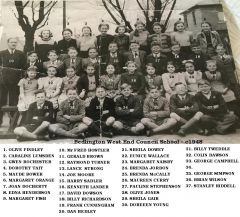
If this is 1948 then nr. 5 (Maud Bower) would be about 14 and that would be about right (born 1934). However, the closure of Netherton Colliery school couldn't have been the reason for the move to West End Council School. It was open long after 1948. I was a pupil there myself for a large part of the fifties.
-
Thanks Tony! That's about as clear as mud to me but I'll take your word for it. My personal experience of Beatty Road is limited to playing in the garden of 35 Haig Road which had a gate through to the garden of the house opposite, on Beatty Road, and the family who lived there. Otherwise, I use Google - and it's not always the most reliable source.
-
I agree! It's a tough one to crack but I'm sure we'll get there in the end.
-
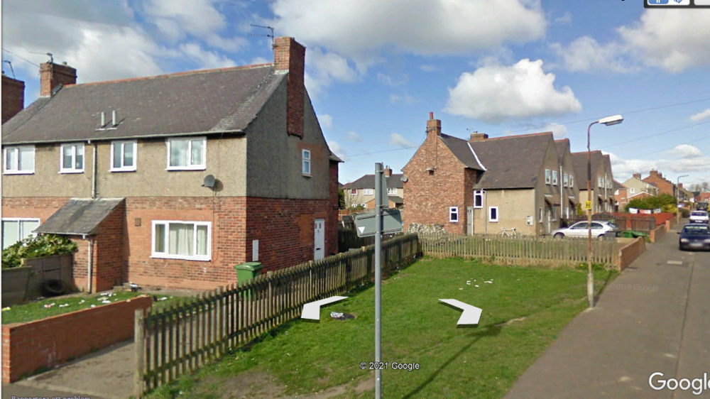
Eggy, I have no idea what happened with my last post. I tried to upload anothe photo and four times it refused to accept it " server error". Then my edit time had run out. Here's the continuation: That's the house which I think appears in @lilbill15's photo and the sharp bend maybe the entrance to Beatty Road. I base that theory on the two features of the house which I mentioned above - side door with adjacent window and that odd, roofed bit between the two houses. Ypu can see in the previous photo that most houses on 'my' side of the road have these features. However, much depends on what stood on the area which now forms the entrance to Knox Road in the 1930s. Were there any railings? If not my other theory is the first house on Haig Road at the junction with Millbank Road. There you have the same layout as in @lilbill15's photo but the sharp bend would then be the entrance to hag Road, not Beatty Road. The photographer would then be standing in the front garden at the bottom righthand corner of this next photo: (Hoping for better luck uploading this time, fingers crossed) However, the style of the house doesn't quite fit the photo.
.thumb.png.ee5e248baf8fd512885b22fa8013673c.png)
-
No offence taken, Tony. I was using Google maps for my description and it appeared to me that Knox Road was a continuation of Millbank Road. Here I've marked Beatty Road (yellow), the houses on the corner of Beatty Road and Millbank Road (pink) and the spot where I think the photographer may have been standing (green).
_LI.jpg.446ffa69db5455d2d02571389b7b2c70.jpg)
-
I don't seem to be explaining this very well. let's have another bash at it. The houses in your photo (shown above) are on Beatty Road. The houses on the other side of the street are also on Beatty Road (that's 'your' house on the left): If I go left to the last house on 'my' side of Beatty Road it's this one:
.thumb.png.a6aa372cda64e9f933f67b01c004f218.png)
-
Neither do I. Eggy and I are discussing Millbank ROAD , onto which Knox Road opens. Sorry if I wasn't clear about this. The only purpose in mentioning Knox Road was to identify the whereabouts of the houses i the photo. I think the photographer may have been standing in the area that is Knox Road today.standing
.thumb.jpg.7493ddab4a696108cf2b849323d3c155.jpg)


.png.d843fa36a02a7e4808675bb1bfd1ea6e.png)
.png.20fbf16642d2bf5ae67be3cf1940fa5c.png)
