.jpg.cdd7f8371d17e2f2f2e2a0e21e02f727.jpg)
Canny lass
Supporting Members-
Posts
3,629 -
Joined
-
Last visited
-
Days Won
426
Content Type
Forums
Gallery
Events
Shop
News
Audio Archive
Timeline
Everything posted by Canny lass
-
-
@lilbill15 Just to round this off could you explain to me where "The Pantry" fits into this? Does it have some connection to nr. 25?
-
Good match but I'm pleased they lost. I couldnt be doing with another night of celebratory drinks in this heat.
-
That explains it! I was starting to think I might be going senile. Google maps and Google Earth use the same pics for the area, from March 2009. I usually concentrate on the more permanent features - lintels, chimneys, brickwork. They don't tend to change as often.
-
.thumb.jpg.7493ddab4a696108cf2b849323d3c155.jpg)
How's the weather in Alberta Vic?
Canny lass replied to Alan Edgar (Eggy1948)'s topic in Chat Central
I'll bet you'll be pleased when that rain comes, Vic! Grandson has 52 degrees in Mali at the minute. -
Change that pint to a whisky and I'd do the same.
-
Now I'm lost! Are there two nr 24 Millbank Crescent - one with a white door, as mentioned in your first post, and this one with a black door?
-
@Alan Edgar (Eggy1948) I don't know how you manage all this clarting! What a job getting those numbers in place!
-
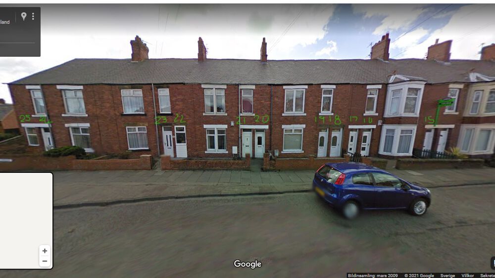
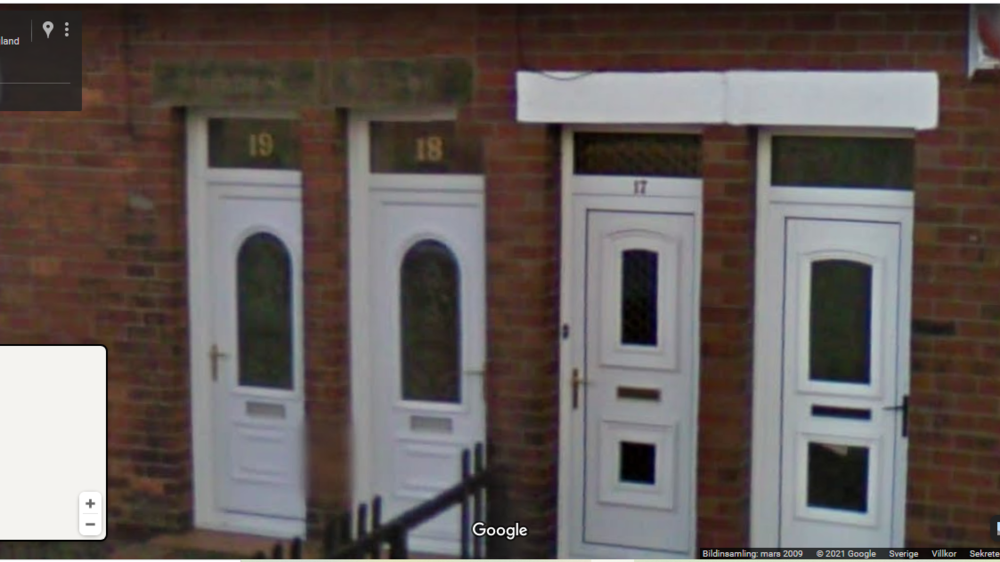
At first sight I can agree with you, but if you look at how it was 1911 there are 25: Look at the double lintel across the door and small window of nr. 25. That's been 2 doors - same as all the other double lintels. Nr 15 is for sale (green notice on pole) but the number isn't too clear on a zoomed pic. Here's a closer pic of nrs. 17, 18 and 19 so that you can recognise the doors.
-
I don't know what happened there. I eddited my post and most of it disppeared when I posted! My theory is that after the first two houses mentioned above, Millbank Crescent consisted of flats. There are 25 dwellings on the census but there are not 25 houses - as the chimney's and bay windows suggest. Number 24 and 25 have been converted to one dwelling and if you count along to number 10 the same thing seems to have happened there with number 11. It seems that number 25 hasn't disappeared it's just beenj incorporated into number 24.
-
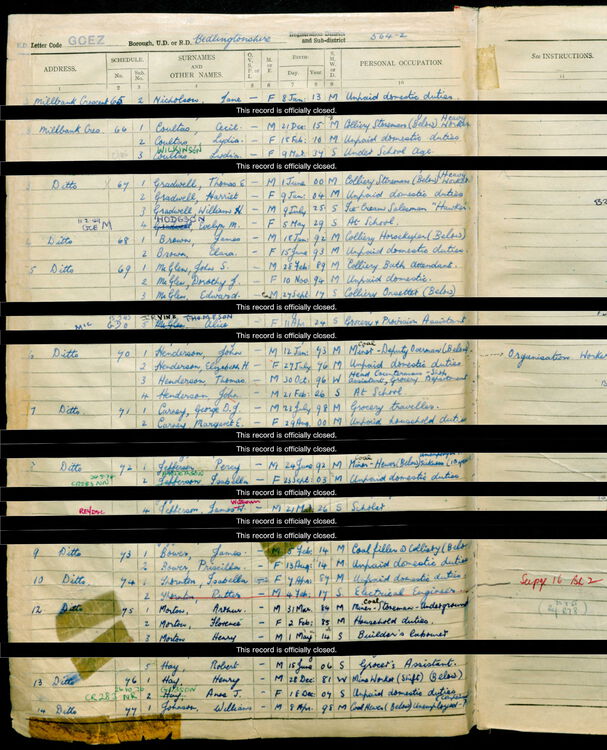
I think I have the answer to the disappearing 25. Looking at the 1939 register there is no number 11. I don't know why. Looking at the 1911 census, there are 25 dwellings on Millbank Crescent. The first of these (next to Millbank Terrace and working towards the station) has 8 rooms and is occupied by Mr. Garthwaite the headmaster at Bedlington's "Public Elementary School". The second dwelling has 6 rooms and is occupied by Mr Mayhew proprietor of a wholesale confectionary business. Today it looks like this: are Looking at Google Earth there are not 25 houses. Looking at 1911, the dwellings go in pairs of 3 roomed and 4 roomed. These must always have been flats: 4 rooms downstairs, 3 rooms upstairs. The chimney pots seem to verify that as well. Today, we can clearly see two doors per bay window for most of these dwellings - one for upstairs, one for downstairs. Number 24 only has one door. The two flats have been made into (or returned to the original) one house.
-
I spoke too soon! I've just looked at the 1911 census and Millbank Crescent had 25 houses. More info following.
-
@lilbill15 I had another look at the 1939 register. This time I looked at the whole street and found that there is no number eleven. There doesn't appear to have ever been a number 11 as the schedule numbers are consecutive and none are missing. Number 25 hasn't disappeared. It's more likely that number 12 has become number 11 and the higher numbers have been adjusted.
-
I'm sure they do but the only thing I'll be buying from UK is tax-free whisky on return journeys (assuming we ever get let out again). Brexit has meant that buying anything from Blighty involves a delivery time of months. Even a first class letter now takes 3-4 weeks instead of four days. I'm still waiting for a birthday present for a grandson - ordered May 7 in good time for a birthday 3 June. Last tracked June 15 at Heathrow Airport where it was said ti o be "in the post". Should this wonder cure you speak of eventually arrive here, despite all odds, it probably wouldn't be allowed in because it's a medication - and not many are approved by the authorities. I'll just have to plod on with my pillarless airy ellipsoid just as it is.
-
I'm sad to say it hasn't been the same since trig pillars went out of fashion.
-
Neither of the available options was what I'd want but now the PM has spoken to the nation. He chose to ask the speaker to relieve him of office. We now have an interim government - the same government with essentially the same powers - to fill the gap while the speaker has talks with all parties to try to form a government. He has four attempts to try to get parties to work together in a government before he must call an extra election. It took 4 months the last time! Sorry to be bombarding your birthday greetings with this Foxy. I'll stop now and wallow in a deep depression over the state of the nation. I'm sure the BBC will be keeping everybody in England informed. Over and out.
-
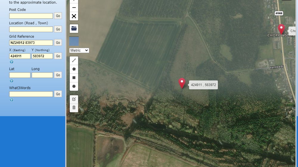
@lilbill15 I just checked it out by putting the numbers into a grid reference-finder: gridreferencefinder.com It came up with this: Just about spot-on for Puce Bush. Useful tool to have on your outings.
-
@lilbill15 I think I've cracked it! The numbers on your pic are a National Grid Reference. I'm not too familiar with it but here's a good site for basic info on using the grid: https://getoutside.ordnancesurvey.co.uk/guides/beginners-guide-to-grid-references
-
Big day tomorrow! The PM must reveal to the nation what his decision is: Will he resign or will he call for an extra election? We'll know tomorrow.
-
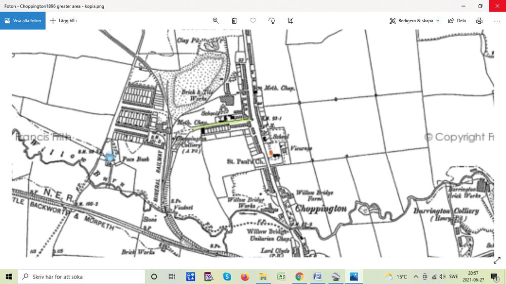
Hi @lilbill15. I’m sorry but I can’t be of any assistance with those numbers. I have no idea what they are. Like, Eggy, I don’t use coordinates. I do like Google Earth for this sort of thing because you can go back and look at earlier views of the same area. Here’s a series of pictures from the area under discussion. I’ll start with a map from 1898 then aerial views of the same area from: 2002, 2006, 2015, and 2020. On each view I marked the spot where I think Puce Bush farm was located (Blue) using St Paul’s Church (Red) and the old road into Choppington Colliery (Green) as reference points. I ended up in roughly the same spot as Eggy. Google Earth gives the coordinates at the bottom of the screen print. It varies slightly pic to pic but not significantly. I probably didn’t land on the same spot with my mouse every time. However, the coordinates shown are close to those that Eggy gives. Eggy: 55.149482, 1.610697 G. Earth: 55o09’03.11”N (North) 1o36’36’37.67”V (West) ... but they don’t resemble anything on your picture: 583972 North 424911 East I’ve no idea what your numbers represent.
-
Honestly, I have no idea either - but for God's sake keep doing it! Your clagging has induced clarity and cohesion to many a topic and a s such has earned its rightful place here on Bedders. Where would we be without you and your clarting and clagging!
-
@lilbill15I meant to reply to this earlier but football and Midsommar got in the way. If you'd asked me 10-15 years ago if SD was akin to the UK National Front I'd most certainly have answered YES. SD has its roots in white nationalism and fascism but the last decade or so has seen quite dramatic reforms in their politics. Their present leader has done a lot to get rid of the 'hard-liners' . How much this has to do with reform and how much it has to do with their getting the party a bad name is hard to say. However, I'm pleased to say, that today there are no SD politicians going around weilding iron bars and attacking non-whites outside night clubs in the capital and today the SD party openly and officially rejects both fascism and nazism. SD is, however extremely nationalistic in its approach to immigration - something we are seeing in many other European countries' as well. Because of the many changes for the better, I'd now liken SD more to Ukip. As I said, I don't like their ideology, but I do respect that they - possibly through the changes they've made within the party - are now the democratically elected third largest party in this country and as such - if democracy was working - should be included. They are instead totally frozen out by the so-called 'democratic' parties. This, and the fact that we have so many small parties, makes it difficult for any party to build a majority government without the aid of pacts being made (and broken - cause of the present crisis) both to the right, left and across the board. Hope that gives you some clarity in the situation. Sorry you've had to wait.
-
Just like that! 👍
-
... and singing (I use that word loosely)! Do I detect a hint of personal experience?
-
Looking forward to it!

.thumb.png.1b254f427b7880163ffa0ff6e40e71d6.png)


.thumb.png.eefbb528dad68118483ae6d2b98b5828.png)
_LI.thumb.jpg.dc63bb7ca00d4fb82f1407fba768f725.jpg)
_LI.thumb.jpg.003e79e699ce4efb29f0390e46f45385.jpg)
_LI.thumb.jpg.c73cc37f37daf88d61e8b55870a3a40f.jpg)
_LI.thumb.jpg.91f5c055fbf41bec2f2268867e6d3e06.jpg)