

.jpg.cdd7f8371d17e2f2f2e2a0e21e02f727.jpg)
.jpg.a8059e59bff91bf6691d0bfedf8fad60.jpg)
-
100% correct! Tankerville Arms, Blue Fountain Inn, Green Fountain Yard nrs. 1 -6 (in the direction Fountain Inn towards Tankerville Yard). That's a great aerial photo! May I ask where you found it?
-
No, you wouldn't be able to identify the Tankerville from that photo. it was much further down the road from the Alma Inn - the "Food Office", as I remember it. In the 1950s. I used to visit with my much older sister to collect "National Dried Milk" for bottle-fed babies, Cod-Liver oil, orange juice and 'Virol' (some sort of malt). Alan, do you have any idea of a date for the photo showing the Tankerville?
-
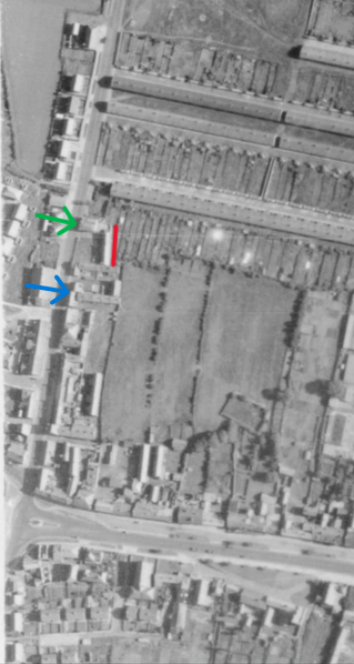
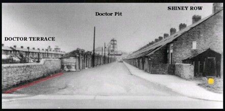
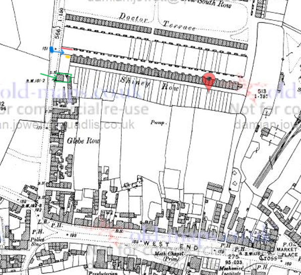
Hi @kayla leigh, welcome to the forum. I think you may have misunderstood the meaning of the word "dwelling". A dwelling is any self-contained structure/space used as a home or even as a place of shelter. It's a very broad term covering everything from houses, flats, single rooms, lean-to buildings or even tents. Nowadays you could even add mobile homes and, houseboats. In other words, a dwelling is ANY place you can call home and where you have your regular place to sleep. I explained my use of it earlier in this topic, July 29 2020: "Fountain Yard comprising six ‘dwellings’ each for one household. Numbers 1 and 2, marked in red, were somewhat larger than numbers 3 – 6 which make up the rest of the row. I choose to call them ‘dwellings’ because I’ve no idea how they were. I’ve heard, but never been able to confirm, that they were no more than lean-to buildings against the back wall of the pub yard." The black building, at the western end of Shiney Row in the photo, is not in Fountain Yard. I'll try to show you why. Look at the photo again. I've marked the black building with a yellow spot and the wall opposite, adjoining the outside toilets on the left of the photo I've marked with a red line: Here's a map (from 1897) with those two objects marked in the same manner: Wall - red and building - yellow. The blue spot on Glebe Row is the location of the photographer and the blue arrow shows the direction he was facing - eastward towards the pit head. I've marked the Fountain Inn with a green arrow and marked the boundaries of its yard in the same colour. The Fountain Inn had 5 rooms housing one family and the yard had 6 dwellings (type unknown) housing 6 families each in one room (according to the 1911 census). These were probably located in the small building/lean-to behind the pub and located within the yard which backs onto the gardens of Shiney Row. Both the Fountain Inn and its yard are well out of view to the photographer who took the photo. I personally have always thought that the black building may be some sort of wash-house purely because it reminds me of similar constructions in many back yards in Netherton Colliery - but that's pure speculation on my part. Hope this helps.
-
Well done! It's hard work doing continued CPR so it's good if a few people can rotate. The more people who can do it the better. It should be taught in schools all over the country. I always find the Bee Gees song 'Stayin Alive' gives a great rhythm for compressions and it's easy to remember because of its title.
-
A Bedlingtonian has made the national news headlines here in Sweden! When seven dachshund puppies became motherless after a dramatic birth an unexpected hero stepped in. Bedlington Terrier Zahara took care of the puppies and began to feed them as her own. When Max Ackberger’s dachshund didn’t survive the birth, the situation became acute for her seven puppies. Max looked to Facebook for help and made contact with Lena Westholm who lived in the same town. Lena¨s Bedlington Terrier, Zahara, was having a false pregnancy at the time and showing strong maternal instincts. The puppies were introduced to her and, despite some initial hesitation, she let the puppies start feeding. At first, Zahara thought it was a little scary but then her mother’s instinct took over. From then on, the puppies were hers. Just now the puppies are both bottle and breast fed but it is hoped that they will soon manage with only milk from Zahara. A true Bedlingtonian!! Well done Zahara. https://www.svt.se/nyheter/lokalt/vast/sju-taxvalparnas-mamma-dog-da-tog-bedlingtonterriern-zahara-over-och-borjade-dia
-
@Mal Is there any organized instruction for the use of these defibrillators, Mal or is it up to an interested individual to find their own? My own experience here is that, while there are clear and concise instructions inside for its use, several users have never seen a defibrillator prior to the need for its urgent use and have had a tendency to panic at the scene.
-
What a great idea!
-
-
In my experience of family history research I've found people's ages to be the absolute least reliable when it comes to determining a date of birth! When the census started in 1841 children's ages up to and including 14 years were recorded accurately. Anybody 15 years and over had their age rounded up or down to the nearest 5 or 10. This practice was stopped for the 1851 and subsequent census surveys but I've found examples in my family of enumerators who continued. Going back to the 1800s quite a lot of people didn't even know their birthday. You are right when you say that parental consent for under 21s was required in 1866 but the legal minimum age for marriage was 14 for males and 12 for females. However, William would be well over the age of 21 so he wouldn't be needing any consent and wouldn't need to lie. The 1841 Scotland census isn't available to me in its original form but a transcription gives William's age as 7 "mo". That census was done 6-7 June so this would give a birth date between 6th October and 6th November the previous year – 1840. This would fit in nicely with the birth date of William Taylor, registered in Meigle, Perthshire, as 25 OCT 1840 to James Taylor and his wife Jess (nee Walker). That might be worth investigating further. Do you know that children in the 1800s were very often named in a certain order? I had a look at William and Elizabeth's children: 1st son is given his maternal grandfather's name. (Robert) 1st daughter is given her paternal grandmother's name. (Jess) 2nd son is given his paternal grandfather's name. (James) 2nd daughter is given her maternal grandmothers name. (Jessie) As both grandmothers shared a similar name Jess/Jessie the 2nd daughter would possibly be given her mother's name - Elizabeth. Carry on with the detective work!
-
Well there you go! Whining and whinging aren't always a bad thing and I'm sure you did both beautifully, Malcolm. Well done, I'm sure this will be a real asset to Bedlington and I'm looking forward to visiting it.
-
Good Luck! Let is know how you get on.
-
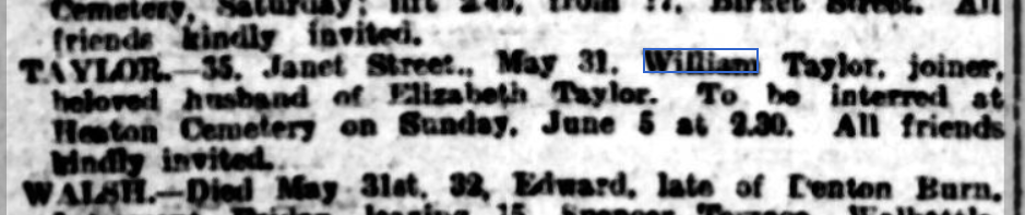
Hi again @Dave Taylor. It's not from the Death Index but at least you can know where he died and where he's buried and it gives you a date to work with in your research. It appeared in the Newcastle Evening Chronicle, Thursday 2nd June 1910 and was repeated in the same newspaper Saturday 4th June 1910. In case you might want to investigate further: Heaton Cemetery is now called Byker and Heaton Cemetery.
-
@Dave Taylor Hi Dave, welcome to the forum. If William's wife was Elizabeth, born Newcastle and living in 1911 in Shieldfield (Canada Street), Newcastle with 2 of her sons, John and George, then I think you're in the wrong area with Brick Lane. Elizabeth is living in Newcastle and, while it's not impossible, it seems unlikely that she would move back with the boys so soon after her husbands death as the boys would have had jobs to go to in Bedlington if they had been living there. Another reason not to move would be that William would be buried in Bedlington (or Bebside which was nearer Brick Road) but still part of Bedlingtonshire. That would be a hard thing to do for a widow. There is a William Taylor, born abt 1842 who's death was registered in Newcastle in December 1909 and that might well be worth having a look at: Name: William Taylor Age: 67 Estimated Birth Year: abt 1842 [abt 1842] Registration Quarter: Oct-Nov-Dec Registration Place: Newcastle upon Tyne, Northumberland, UK Death Date: Dec 1909 Inferred Death Place: Northumberland, United Kingdom Volume:10b Page: 56 Hope this helps. Let me know how you get on with your search and if I can be of any more help.
-
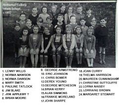
 @Nicola Riley So pleased that you found her! A little correction: The photo doesn't show a PE class. Miss McLean (Later Mrs McDonald) was a PE teacher but this is a class photo for which Nancy (Miss McLean) was the form mistress. All classes had a form teacher. The class would go to her directly after assembly in the morning and she would fill in the attendance register before the pupils went to their first lesson. As Miss McLean was the only teacher of PE for girls then Joyce would certainly have gone to her PE classes.
 -
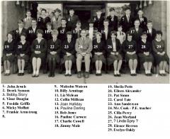
 That’s the James Appleby that I remember! Nr 7 back row right.
.thumb.jpg.7493ddab4a696108cf2b849323d3c155.jpg)

