Contributor Leaderboard
-
mike white
New Members4Points5Posts -
Mal
Members3Points109Posts -
kayla leigh
New Members3Points6Posts -
2Points6,969Posts


Popular Content
Showing content with the highest reputation since 27/06/26 in Posts
-
3 points
-
First letter any thanks for the information. What you read as a P is a G I always just thought it meant girl. The p and g are hard to distinguish, because of how they were engraved. And the photo is not clear. Found your reply both interesting and informative. Many thanks.1 point
-
Normal civilians carried these during ww2 incase they were killed during an air raid PSFR is for ration card personnel supply food information 376 is 376 is her personal number that she wood use at the bedlington food office bedlington station was classed as a luftwaffe target as the coal would be transported to river Tyne for merchant ships1 point
-
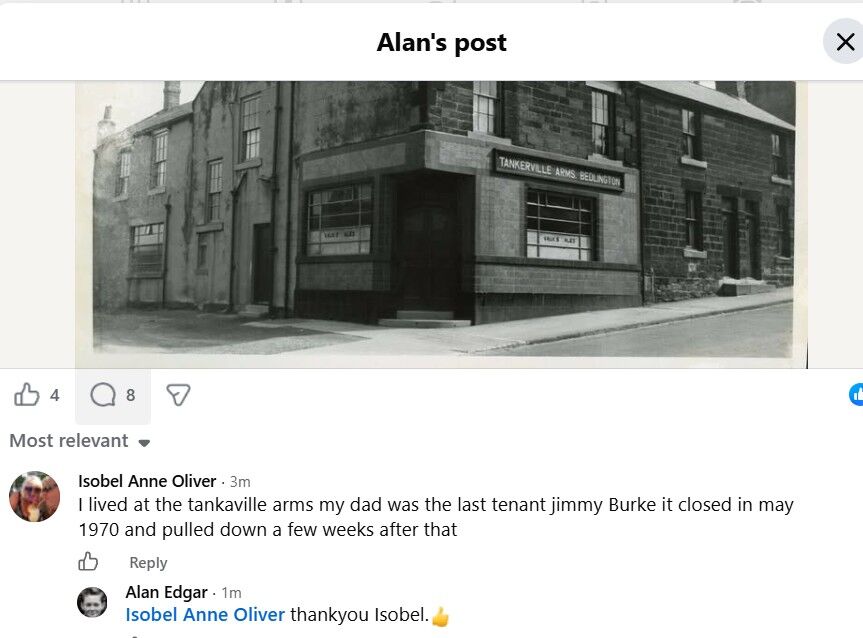
Checked on the Facebook Group Bygone Bedlington and the only info I can get is that the photo is pre 1970 :-
 1 point
 -
No date with the photo. Normally I have the info ie year and who posted it as part of the name the photo is saved under. So in this case I would assume the member of the group I got if from did not comment with any info other than the name.😒1 point
-
Alan on the same page as the aerial view above its got bank cottage also cornwell crescent. (The not cropped version) There is a few of bedlington and surrounding areas. I found them helpful alongside the maps you had already shared.1 point
-
https://historicengland.org.uk/images-books/archive/collections/aerial-photos/ Not sure if linking is allowed apologies if not, its historic england Ariel photo explorer1 point
-
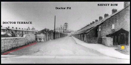
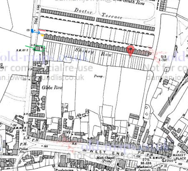
Thank you both, so in photos showing glebe row with what is labeled the tankerville, would the fountain and fountain yard have been on the land you can see between shiney row and the tankerville? Its quite a dark image. Im not sure why my name is coming up kayla (unless it using my google profile) its mikki (researching Thompson and Bank cottage)1 point
-
Hi @kayla leigh, welcome to the forum. I think you may have misunderstood the meaning of the word "dwelling". A dwelling is any self-contained structure/space used as a home or even as a place of shelter. It's a very broad term covering everything from houses, flats, single rooms, lean-to buildings or even tents. Nowadays you could even add mobile homes and, houseboats. In other words, a dwelling is ANY place you can call home and where you have your regular place to sleep. I explained my use of it earlier in this topic, July 29 2020: "Fountain Yard comprising six ‘dwellings’ each for one household. Numbers 1 and 2, marked in red, were somewhat larger than numbers 3 – 6 which make up the rest of the row. I choose to call them ‘dwellings’ because I’ve no idea how they were. I’ve heard, but never been able to confirm, that they were no more than lean-to buildings against the back wall of the pub yard." The black building, at the western end of Shiney Row in the photo, is not in Fountain Yard. I'll try to show you why. Look at the photo again. I've marked the black building with a yellow spot and the wall opposite, adjoining the outside toilets on the left of the photo I've marked with a red line: Here's a map (from 1897) with those two objects marked in the same manner: Wall - red and building - yellow. The blue spot on Glebe Row is the location of the photographer and the blue arrow shows the direction he was facing - eastward towards the pit head. I've marked the Fountain Inn with a green arrow and marked the boundaries of its yard in the same colour. The Fountain Inn had 5 rooms housing one family and the yard had 6 dwellings (type unknown) housing 6 families each in one room (according to the 1911 census). These were probably located in the small building/lean-to behind the pub and located within the yard which backs onto the gardens of Shiney Row. Both the Fountain Inn and its yard are well out of view to the photographer who took the photo. I personally have always thought that the black building may be some sort of wash-house purely because it reminds me of similar constructions in many back yards in Netherton Colliery - but that's pure speculation on my part. Hope this helps.
 1 point
 -
1 pointHello. I was part of the firefighting team that responded to the old pub on the site of the Vibe/MOOD bar in Bedlington. 1989 I believe. Has anyone got any articles/photos of the fire. I live in Australia now so I'm just trying to retrace my history. Thanks for your help. Mike1 point
-
1 point
-
1 pointThank you Alan, I'm relieved it's not me! I'm used to going straight to this page then sometimes going to other areas later, I can live with it but would call it a downgrade rather than an upgrade! (perspective!) I still miss the live camera... 🤸1 point
-
1 pointFantastic. I served with Phil and yes, he's 100% correct about the plant pots. :-)1 point
-
1 pointThanks, Alan. That was part of the clean up operation. We were there in the early hours of the previous night, firefighting. It was great to see the photo. Brought back instant memories. 🙂1 point


.thumb.jpg.7493ddab4a696108cf2b849323d3c155.jpg)