.jpg.cdd7f8371d17e2f2f2e2a0e21e02f727.jpg)
Canny lass
Supporting Members-
Posts
3,446 -
Joined
-
Last visited
-
Days Won
354
Content Type
Forums
Gallery
Events
Shop
News
Audio Archive
Timeline
Everything posted by Canny lass
-
.thumb.jpg.7493ddab4a696108cf2b849323d3c155.jpg)
Small building at the end of Furnace Bridge?
Canny lass replied to Joe Ridley's topic in History Hollow
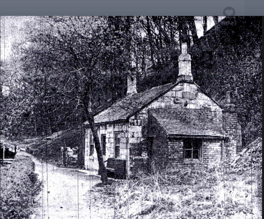
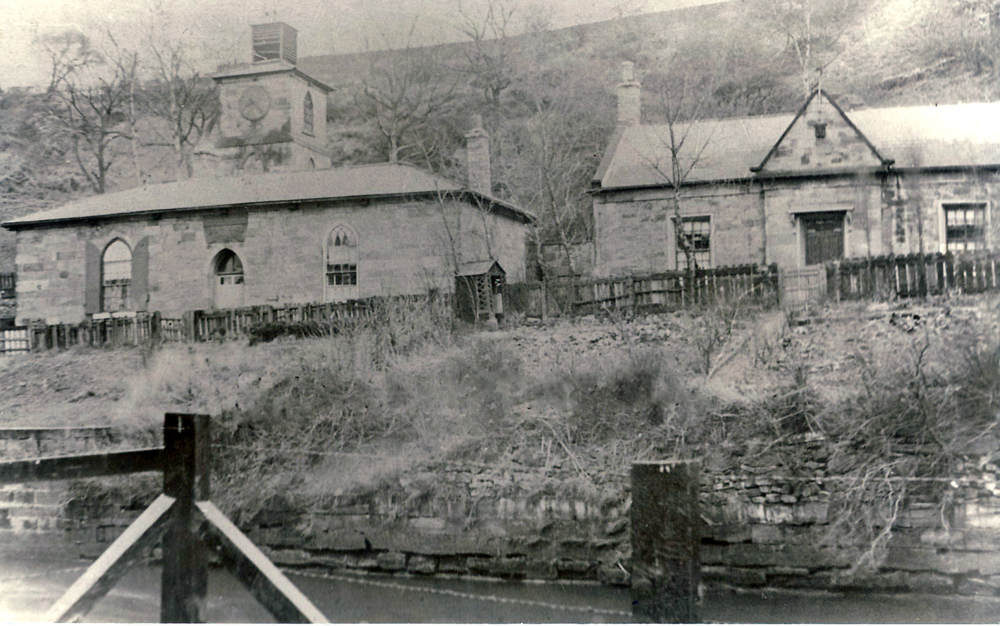
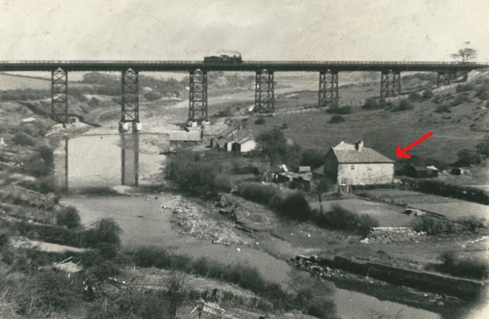
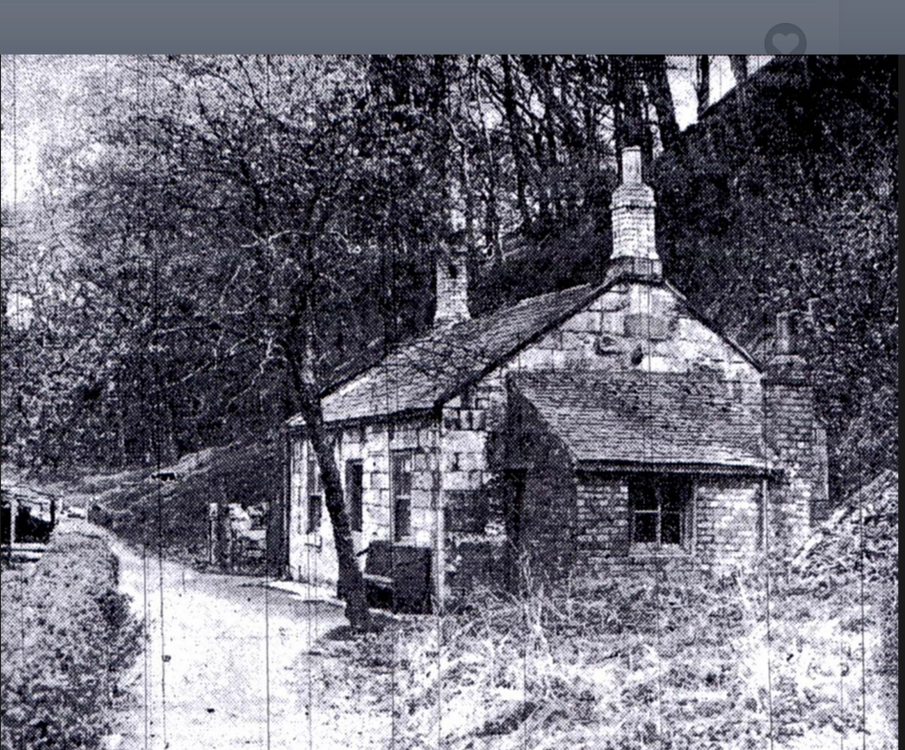
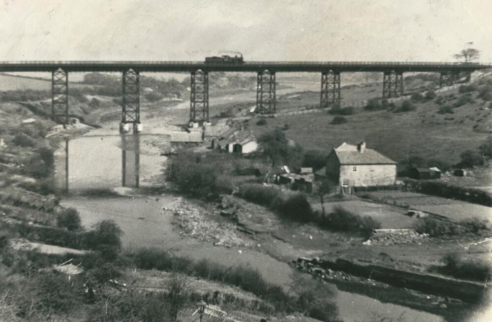
Thanks for the input @James! This area is extremely important to me as my parents lived in Clock House and I had sisters who were born and died there. I've researched it backwards, forwards and inside out but I'm still not 100% sure of my findings. Bridge House, I'm 100% certain so I try to guage everything from there but I've had several theories along the way and haven't ruled any of them out yet. My own personal childhood memories of the immediate area are limited to taking the bus across the bridge to visit family in one of the rows at the top of the hairpin bend, Stone Row, and nothing more. It would help me enormously to know exactly where the entrance to the woods was. I don't suppose you could point it out on a map for me? I fully agree with you about the gardener's cottage. I feel it seems a bit on the small side for a boiler room or any other sort of power house for industry of these dimensions and it seems reasonable that the gardener had his dwelling near at hand. This was the case at the top of the bend where Cowpen gardens lay.. Getting back to Rose Cottage, I can't agree with you that Rose Cottage, as I call it, and Toll House, as John calls it, are one and the same thing. Here are the differences that I see. for the sake of easy comparison, I am posting these two photos once again but this time side by side: First of all, forget whatever you've been told about size not being important! It really is, at least when it comes to comparing buildings. Toll House shows: max 2 stones width between door and window max 2 stones width between window and gable end Windows 2 panes wide full width lintel stone above and below the window frame No stone surround on windows Rose Cottage shows: At least 6 stones width between door and 'porch' plus further 2 stones width to door At least 6 stones width between window and gable end Windows 4 panes wide No lintel stone above the window Windows have full stone surround Apart from these details the obvious thing that's missing in John's photo of Toll Cottage is Clock house - which would be seen in a photo taken from that angle as there was very little space between them. What do you think? I have a couple of other possibilities for Toll House in mind but it depends on where the entrance to the woods was located. There are several instances in census records of "cottage(s) in the woods" that might fit the bill if their location is right in relation to the entrance. Grateful for any help you can give me here. -
You might try the Northumberland Archives,Michael, https://northumberlandarchives.com Thomas Davison has popped up in my reasearch earlier on documents related to Bedlington Colliery - last one dated 1857.
-
In my family too but they were in coal-mining. They've probably tread common ground. Re the location of the Rose & Crown Inn in the photo:
-
A fantastic work, researched and written as a tribute to his grandfather who, I'm sure, would be extremely proud of his grandson.
-
-
I think it's more likely to be the village school because of the stone work. The colliery school was brick built (with bricks from Choppington Brickworks if my memory serves me right). The bricks were of uniform, standard, size as can be seen in other photos of the colliery school. These are irregular in shape and size and they look more like stone.
-
.thumb.jpg.7493ddab4a696108cf2b849323d3c155.jpg)
Small building at the end of Furnace Bridge?
Canny lass replied to Joe Ridley's topic in History Hollow
Sorry, editing problems again! continued; On every census record I've waded through over the years for the riverside area, Rose Cottage is next door and to the east of Clock House. There are no further dwellings recorded in an eastward direction along the river. When the enumerator moves from the Iron Works towards the bridge and hairpin bend he records the dwellings in the order: Bridge House (sometimes called Bridge End House), Clock House and Rose Cottage before goung up the hill to Se View, paradise Row etc. In John's picture there is a gate leading into, or out of the Halfpenny Woods. This suggests to me that it is the Toll house and I believe it to be on the riverside (there were several Toll Houses on Lord Ridley's land, at least one up on the hill), as the ground slopes steeply upwards behind it. Comparing John's Toll sign photo and his Toll Cottage photo of 2013 suggests to me that the sign was placed at the right corner of the gable end facing away from the photographer in the cottage photo. A very small portion of that gable end is seen on the right of John's sign photo. It has a very, very short eves over-hang and a tree, behind a block stone wall, immediately to its right. Furthermore, there is a down-pipe from the gutter which leans slightly inward towards the bottom. All three are also present in John's cottage photo. Assuming that the sign is placed to be read by people entering the woods, I believe the Toll Cottage photo to be taken from inside the woods and therefore looking towards Bridge House. Therefore, I think that it may possibly be a dwelling recorded as Bebside gardens in the 1901 and 1911 census. The gardens skirted the river bank on the Bebside side of the river. -
.thumb.jpg.7493ddab4a696108cf2b849323d3c155.jpg)
Small building at the end of Furnace Bridge?
Canny lass replied to Joe Ridley's topic in History Hollow
Eggy, I'm not sure that I agree with John on this one if he is saying this is Rose Cottage on other sites. January 2, 2013 John posted a picture of what I believe to be the same building but called it Toll Cottage. He also posted the photo of the Toll sign, which you repost above, on the same date - both from his private collection. -
This week's quiz: Where in London did an IRA bus-bomb occur in February 1996? Who was the King of England, Scotland and Ireland from 1625 to 1649? Who is the patron saint of carpenters? What is the capital of Nicaragua? What would your occupation be if your work involved you with MIG and TIG? Which sportsman was nicknamed ‘Guy the Gorilla’? Who composed the Pathetique symphony? Which spirit forms the base of a ‘Horse’s Neck? How many arms bearing suckers does a squid have? Who had a number one hit with All Kinds of Everything? Which British PM resigned over the Suez crisis? How many geese were “a laying” in the Christmas song? I’ll bet you didn’t know …. Benjamin Disraeli’s false teeth once fell out whilst making a speech in the House of Commons Answers on Thursday next week.
-
I knew I had one somewhere! The larger building to the right of Viaduct Cottages (sorry, I said Keelmans Row earlier. That was a mistake)
-
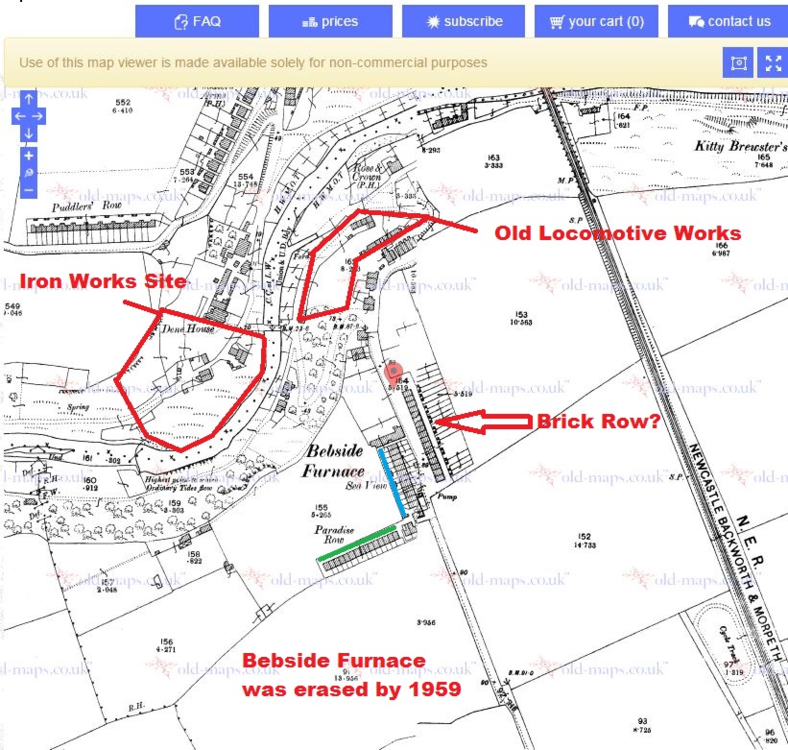
Welcome to the forum, Bhx7! You are correct. The Rose & Crown Inn was located to the west of the viaduct and situated between Keelmans Row and Rose & Crown Row. (Ignore the red star) Census enumerators were creatures of habit who followed a strict route. In the 1901 census, having left the Sea View/Paradise Row area (Bottom right corner of map) he entered the Iron Works area and followed his route including Fergusons Row (where my father was born, 1900) proceding through Old Factory Yard and its offices, he then makes his way downhill to the riverside where he records in the following order as he walks towards the bridge at the foot of the hairpin bend: Green – Rose & Crown Inn (marked P.H. ’Public House’ on the map) Orange – Rose & Crown Row (nrs 1-6) Pink – Bridge House Yellow – Clock House Blue – Rose Cottage, the last dwelling in his district (Cowpen 16)' The Rose & Crown Inn is actually named on this second map from 1897 just 4 years before the census. Thanks to Eggy for the art-work on this last map. As you see, he's much better at it than I am!
-
.thumb.jpg.7493ddab4a696108cf2b849323d3c155.jpg)
Small building at the end of Furnace Bridge?
Canny lass replied to Joe Ridley's topic in History Hollow
The ruin you've queried as Toll House in the picture, is Rose Cottage - according to census records. -
I tried to edit the last post but when i pasted in my text, after the file, the wordsa nd letters ran amok changing font and size here, there and everywhere. I tried to write it direct on site but time ran out for editing. I'll have another go at pasting it in this post and see what happens BUT I'm not going to try and rewrite it if the same thing happens! I looked at the 1911 census and the 1939 register and compared the number and placement of dwellings in relation to three fixed points on Glebe Row: Fountain Inn at the northern end of Glebe Row, Tankervlle Arms and the Alma Inn situated towards the southern end of Glebe Row. We can assume that the position of all three has remained constant. This information was then plotted on a map dated 1922 where individual buildings could be clearly seen. For the 1911 census I give the familiar address – that given by the resident. For the 1939 register I give the official adress - that given by the enumerator as this is the only one available. However, in the 1911 census, all dwellings situated between Arcade and the Alma Inn have the official address, Glebe Row but the residents choose to call it anything from Tankerville Yard to Front Street. Between 1911 and 1939 the number of dwellings in the enumerators area between Fountain Inn and Alma Inn increased only slightly from 59 to 68 dwellings. In 1911 the area from Fountain Inn to, but not including, Arcade lists 28 dwellings. The same area 1939 lists 36 dwellings. Most of this increase can be accounted for by two roomed dwellings being divided into one room dwellings and the five roomed dwelling adjacent to Olivers Buildings becoming five separate dwellings. The area from, but not including, Arcade to Alma Inn lists 27 dwellings in 1911 and this is reduced by one, to 26 dwellings in 1939. In other words there hasn’t been much change and Arcade appears to be consistently situated adjacent to the same yard, Renwicks Yard which is the second ’yard’, respectively the third on the 1911 and 1939 records as the Alma Inn yard was a later addition. Worked fine! I clearly didn't choose 'plain text' when posting.
-
Well, that’s nice to hear but as I’ve spent an hour looking for it and giving it a bit of a brush up to make it readable, I may as well post it. It might help somebody else. In the attached file, by ’dwelling’ I mean a unit which houses one family. Here, a unit can be anything from 1 room to 5 rooms and a family can be any number of persons between 1 and 7. The greater majority of dwellings in the area under discussion are of 1-2 rooms. Arcade 1911-1939.docx
-
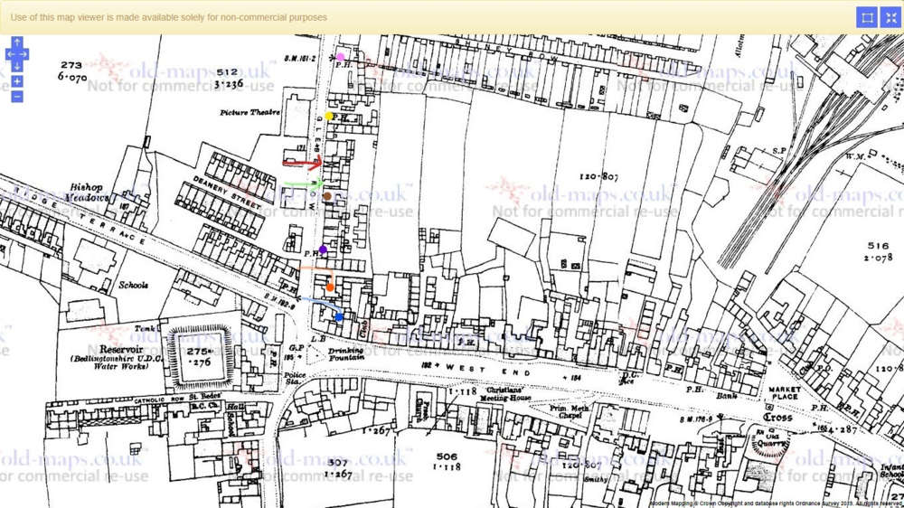
Renwicks yard (as it's named i the census records) was close to Arcade - assuming my research gives a good result. There were only three dwellings, facing Glebe Row, which separated the two. renwicks Yard was situated further south towards Front Sreet. Here's a map showing what my picture of Glebe Road is based on the 1911 census and the 1939 register. It's a map from 1922 but not a lot changed between 1911 and 1932. I'll see if I can dig out my research notes and post them so you can see how I've reached that conclusion. Pink - Fountain Inn Yellow - Tankerville Arms Red - Arcade, nrs 1-6 Green - Renwicks Yard, nrs 1-5 (possibly 1-6) Brown - Renwick House Purple - Alma inn Orange - Alma Inn yard, nrs 1-2 (possibly 1-3) Blue - Kidds Yard
-
They are so welcome and if they ever find a photo or any other information about Arcade I'd love to see it.
-
I should point out that the buldings were there even if the name was not. The end of the 1800s and the introducton of a postal service created a need for more specific addresses and many 'familiar names' became official.
-
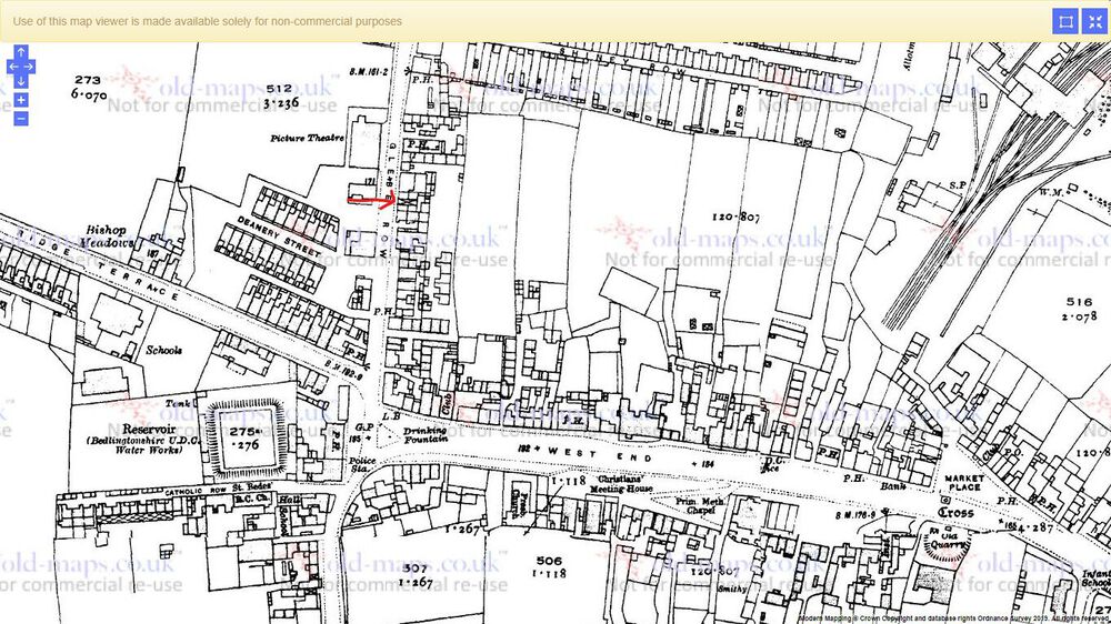
I believe Arcade (no definite article) features on maps from as early as 1860 but not by name - only the buildings. Comparing the enumerators route along Glebe Row in the 1901 and 1911 census together with the 1939 register, I pinpoint it here (map from 1922): My parents lived there 1935-39. The name "Arcade" doesn't appear on the 1901 census where everything on the east side of the road, with the exception of the Alma Inn and the Tankerville Arms, has the address "Glebe Row". First in 1911 can we see that the six resident families are calling it "Arcade" - the majority without a number (only 2 and 6 give a number). The district enumerator, however, does not use the address "Arcade". He is still calling it Glebe Row. From this I draw the conclusion that Arcade is the familiar name used by the residents but not yet officially accepted. As the residents are calling it "Arcade" I can only assume that the place has some features of an arcade and I believe that the 'alleyway' I've pointed out above was covered (hence the elongated x which appears on this and all other maps way back to 1860. This position is also consistent with the 1939 register.
-
Here we go again! Quite a few here that I couldn't answer so get your thinking caps on: Why was General Claus von Stauffenberg executed in 1944? What is the capital of Qatar? By what name was tap dancer Luther Robinson known? Which unit amalgamated with the Royal Flying Corps in 1918 to form the RAF? From which country does the dish ‘enchilada’ originate? Which word connects: crab, mite, monkey, plant and wasp? Which golfer won the 1997 Us Open? What was Charlie Chaplin’s middle name? Into which bay does the River Ganges flow? Who was the male star of the film Lolita? Who plays against Celtic in an Auld Firm derby match? Which country is served by Findel Airport? I’ll bet you didn’t know …. Lord Byron resorted to curlers to give him wavey hair. Answers on Thursday next week.
-
Thank you guys! I did have a good one but didn't get my roll in the snow for the third year in a row. Plenty of snow this year and I started my training for it on Xmas Eve as usual but a series of thaws folowed by minus degrees left the snow with a hard, icey crust which hurts like H--l so I gave it a miss. One of the grandchildren did it for me instead:
-
Answers to last week's quiz: Victoria Cross for acts of military gallantry or the George Cross, awarded to all ranks of the services and also to civilians. They are equal in stature A skirt worn by a Greek soldier 2 Andrew Ridgeley Barn Owl Christian Calcium Firethorn John Constable Cuba Southend United John Cobb New quiz tomorrow.
-
.thumb.jpg.7493ddab4a696108cf2b849323d3c155.jpg)
Ravensworth & Liddle's Street- Bedlington Station
Canny lass replied to Alan Edgar (Eggy1948)'s topic in History Hollow
I'm a bit confused by the red star, Eggy. Isn't that the spiritualist church we discussed recently? If so then Muter's would have been facing the road on the site of the two houses to the left of the white car. The 'pop-factory' is not a place I was familiar with - only their products. -



_LI.thumb.jpg.4bb2b4f2a23e1e1df9c0b63d6f01c83f.jpg)

.thumb.jpg.78bba40c8e7af36b79d6e3157860fb83.jpg)
.thumb.png.8362ab1ad5a339b2f6f0ad3cfe53e730.png)