.jpg.cdd7f8371d17e2f2f2e2a0e21e02f727.jpg)
Canny lass
Supporting Members-
Posts
3,619 -
Joined
-
Last visited
-
Days Won
419
Content Type
Forums
Gallery
Events
Shop
News
Audio Archive
Timeline
Everything posted by Canny lass
-
.thumb.jpg.7493ddab4a696108cf2b849323d3c155.jpg)
Bedlington Openreach full fibre rollout
Canny lass replied to Andy Millne's topic in Talk of the Town
No, no, no! They are just saving the best bit till last - like you'd do with your Sunday dinner. -
Hi Douglas, welcome to the forum! It's amazing the value that's placed on photos. Ask most people what they'd save first if the house went on fire and they'd say 'photos'. They can never be replaced. Have a look through the gallery photos here. You may find some relatives on school photos or mining photos. Most have some, or even all, names added. It's a fantastic resource for research.
-
.thumb.jpg.7493ddab4a696108cf2b849323d3c155.jpg)
Bedlington Colliery Institute Scroll of Honour
Canny lass replied to PaulJ's topic in History Hollow
Is that where I got it from! It's been filed away on my PC for ages. Looking at the date of the download it's only 2 days after you mentioned it. It is certainly an extremely good and informative account of the movement in the north east. I had no idea that it was anything other than a watering hole. I wouldn't hesitate to recommend it either but I have to disagree that it was only for men, working or otherwise. (Stockdale outlined nicely a period in the movement's history when there were more white-collar then blue-collar members). I've come across plenty of instances while reading about it that show women were admitted to the MI early on in its history: https://historicengland.org.uk/images-books/publications/iha-mechanics-institutes/heag187-mechanics-institutes-iha/ ”Originally, few Mechanics’ Institutes encouraged or allowed female members, although this changed towards the end of the 19th century. Where women were admitted, they often had restricted access: at Shrewsbury, for example, women paid half the subscription of men but were only allowed to attend lectures and use the library. After 1850, many larger institutions started to offer special classes for women, particularly in English.” https://dangerouswomenproject.org/2016/08/17/bradford-female-educational-institute/' ”One thing is certain: the girls and young women who attended the Institute were made of stern stuff. Unlike the mainly middle-class women attending daytime classes at Manchester Mechanics’ Institute for instance, the women of the Bradford Female Educational Institute worked for a living.” http://blogs.bbk.ac.uk/bbkcomments/2020/01/08/the-london-mechanics-institute-its-foundation/ The Institute’s egalitarian ethos even extended to women who could attend lectures from 1825 and were able to become members in 1830. It's certainly a fascinating history and must have done a lot to improve education and literacy in Bedlington. Worth a mention on our timeline perhaps? -
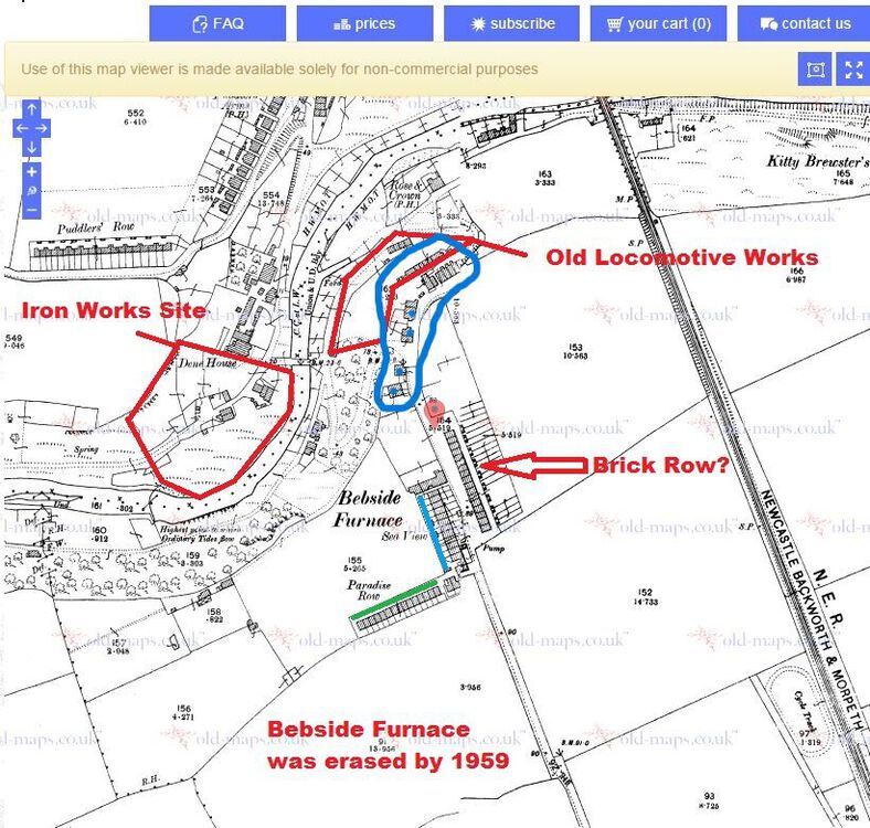
Sorry! There was another page of notes that I'd missed. All of the above is correct but there is one more Davison family which I think it is Lynnes family living at 29 Old Factory. Father, Robert 27, mother, Annie Jane 25, daughters Lillian and Annie 3 yo and 8 months old. The handwritten census form is available. The area had many name changes over the years and the residents used one system of identifying where they lived while the enumerator used another. Old Factory is the adress given by both the resident and the enumerator. I can say with certainty that the blue 'circle' contains the adresses 1-24 Old Gate Row and 25-32 Old Factory. Following the enumerator's route from Old Factory to his next port of call - Clock House, I'd suggest that the eight dwellings of Old Factory are those which I've marked with a blue dot (sorry if it's confusing with only blue but it seems to be the only colour available today!). These are at the top of the bank leading from the bridge and may be the reason why they are also referred to as Bridge End by residents. If Lynne would like the census form filled in by Lillian and Annie's parents let me know. Perhaps she can send an e-mail adress through you Eggy, or we can message it in two steps, me to you, you to Lynne.
-
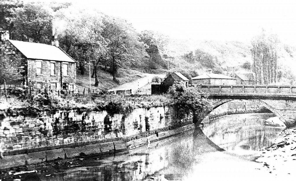
Bridge End, prior to 1912 called Bridge End House, is the house at the end of the Bridge on the Bebside side of the river seen to the left of the attached photo. In both 1901 and 1911 it housed four families in dwellings, numbered 1 -4 in 1901 and 5-8 in 1911 when the numbers continued on from Clock House. I've never seen the name "Bridge End Cottages" on any map, census or electoral records. There were no rows of any great length in Bebside Furnace. Even the Bebside Furnace rows at the top of the bank only went as far as 42 at most (Brick Row). To live in number 46 of any Row would mean leaving the Furnace area and moving towards Cowpen on Front Row, which had 140 houses. I’ve researched the furnace area well as 70% of my family was living there from the turn of the century through to the 1930s. There are a few Davisons there but no Lilian or Annie. Nearest name match i can find is Julia Ann Davison a 60 yo widow and her children: David Davison 28, Agnes Davison 26, John George Davison 21, and Julia Annie Davison 16. This family lived at Old Gate, Bebside Furnace which later became Doctors Row. If Lynne can give me anymore info I’ll see if I can help her.
-
-
.thumb.jpg.7493ddab4a696108cf2b849323d3c155.jpg)
Bedlington Colliery Institute Scroll of Honour
Canny lass replied to PaulJ's topic in History Hollow
continued: Having read Stockdale's work I now think I, and possibly we, may be confusing the number of Mechanics’ Institutes with the number of Institute buildings because there seems to have only ever been ONE Mechanics Institute in Bedlington. Briefly (by my standards) those points of interest, gleaned from Stockdale. and relating to our discussion, are the following. 1824 Ten Mechanics’ Institutes in England of which eight were in the North East and Durham. Among these, only Alnwick and Newcastle were in Northumberland. 1825 Twelve MIs in the north east, Hexham, Morpeth and Tynemouth Institutes established. 1827, 1829, 1830, 1831 With the exception of one institute 1828, NO MIs were established in the entire North East. This was due to the effects of the depression. This places a large question mark on Evan Martin’s claim of the Ironworks MI being established 1829. 1834 – 1846 Crisis years in the movement. Only 13 new institutes established. 1847 – 1851 Revival of the movement 1847 The location and economic base of MIs was established between 1847 and 1851 1848 Bedlington Mechanics Institute established. Its economic base was Bedlington Iron Works. 1852 – 1873 Government interventions in education are introduced and public libraries opened. This heralds the demise of the movement as its traditional services now have strong competition. 1855 -1862 The North East movement reaches its peak of activity 1874 to 1902 The MI is still facing strong competition for its traditional services of education and libraries, added to which the institutes are now amalgamating with the Working Mens’ Institutes as the social and drinking side of the movement has gained ground, being almost the only function they have left. 1878 Delegates reports on their Institutes to the Northern Union Annual Meeting were said to be of a ”satisfactory nature”. There was no cause for concern for the movement. 1881 Delegates reports, including from Bedlington, were giving more details on membership, activity and finances and concern is expressed that MIs are still extremely dependent on financial support from the upper classes. This dependency continued throughout the remainder of the century. The death of MIs in the North East: The financial support of the upper classes facilitated a lot of rebuilding and refurbishing within the north east movement during the latter years of the nineteenth century, something Stockdale describes as a possible ”mission of responsibility toward educational and social improvement of the working-classes”. (Netherton got a reading room!). However, it didn’t seem to help other than allowing the movement to go out with a whimper rather than a bang. Bedlington Mechanics’ Institute, which had 200 members in 1906 hade NONE in 1907. Like Monty Python’s Norwegian Blue parrot it had ceased to be. It was extinct. It was dead. The movement ended in the north east in 1913. Several establishments retained the name Mechanics’ Institute, or something similar, but they are basically social clubs. Source: http://etheses.dur.ac.uk/5614/1/5614 3030.PDF In light of that I suggest that Bedlington Mechanics’ Institute, established 1848 at Bedlington Ironworks, may have had its origins in the Society for Mutual Improvement at the same place. I don’t know when that was established, possibly 1829, but i’ts well documented that BIW had students from all over Europe. I’d further suggest that the institutes located at Bedlington Station Colliery and Market Place Bedlington were all part of the same ’Bedlington Mechanics’ Institute’ created to provide easier access for people on the Bedlington side of the river. -
.thumb.jpg.7493ddab4a696108cf2b849323d3c155.jpg)
Bedlington Colliery Institute Scroll of Honour
Canny lass replied to PaulJ's topic in History Hollow
Warning! make a cuppa this may be long! Thanks James and thanks Symptoms! I knew there’d been a discussion somewhere. I’ve had an opportunity to rummage through my vast amounts of notes. I see now that I was confusing the date 1855 as the founding of the Mechanics’ Institute (MI) when it was in fact the date of Michael Longridge’s departure from the Ironworks. However, I wasn’t too far out. I spent yesterday and this morning reading a document which I started reading at the time of the last discussion. Symptoms, if you’re interested in MI history in the north east, and not just Bedlington, then I can absolutely recommend it. It’s an academic thesis but the language isn’t overly academic and, whatever their education, anyone with a keen interest will find it readable. Excellent bibliography too, which gives plenty of sources for further research should you need them after reading. The document is Clifton Stockdale’s doctoral dissertation from 1993, entitled: Mechanics’ Institutes in Northumberland and Durham 1824-1902 Stockdale traces the Mechanics’ Institute movement from its beginnings in London 1823 but, as the title suggests, the main body of his dissertation follows the introduction of the MI movement in the north east (1824), its development and eventual demise. He discusses along the way contributory factors and their effect on the movement – among them the 1826 depression, various reform bills, trade union movements, economic patronage, social and cultural factors and a whole host of other interesting things. -
.thumb.jpg.7493ddab4a696108cf2b849323d3c155.jpg)
Bedlington Colliery Institute Scroll of Honour
Canny lass replied to PaulJ's topic in History Hollow
Hang on a minute! There's something here that can't be right. If The MI was celebrating its 38th anniversary in 1889, it surely couldn't have been founded in 1829 as Evan Martin says? I was pretty sure it was founded in 1855 or thereabout. I'll have to dig out my notes and refresh my memory. -
.thumb.jpg.7493ddab4a696108cf2b849323d3c155.jpg)
Bedlington Colliery Institute Scroll of Honour
Canny lass replied to PaulJ's topic in History Hollow
Thanks for the heads up, James. I'll have to have another look at that piece of my research. -
.thumb.jpg.7493ddab4a696108cf2b849323d3c155.jpg)
Bedlington Colliery Institute Scroll of Honour
Canny lass replied to PaulJ's topic in History Hollow
I’ve only seen the MI mentioned on the 1897 and 1910 maps but I can tell you a bit of its history because it featured in my (on-going) research on Michael Longridge who was the initiator of the Mechanics Institute in Bedlington. As far as I’ve been able to see it was established in or around 1851 in the building which later housed Peter Bacci’s shop, where it can be seen on James’ map of 1860. It was founded by the 'Society for Mutual Improvement', Bedlington Iron Works and was originally called the ”Literary and Mechanics Institute”. I’ve found it mentioned as such in several documents, among them: Great Britain. Parliament. House of Commons. Reports from Committees. Vol. 3 Page 227 (published 1853). Five years later, however, The Literary and Educational Year Book, page 262 (published 1859) , refers to it simply as ”Bedlington Mechanics Institute”. It would seem to have relocated to the position now occupied by the Community Centre in 1888. This is the old Court House - shown on the 1860 map . The court house was vacated in 1888 when the petty sessions court moved into the new court house and police station next to the Red Lion. Of the old court house it can be read that while the date of opening is unknown, the date of closure was 1888 when "a new combined police station and court house was built and the old court house near the Market Place became the Mechanics' Institute". https://www.prisonhistory.org/lockup/bedlington-court-house This is supported by an extract from The Monthly Chronicle of North-country Lore and Legend, Vol 3, page 93, (published 1889) where the entry for December 1889 (relating to that year's events) states: "The committee of the Bedlington Mechanics' Institute celebrated the 38th anniversary, by planting a number of trees in the ground in front of the large building in Front Street". This also supports the institute being established in 1851. -
-
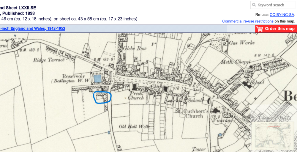
It was indeed at the top end of Bedlington and next door to the presbytery of the Roman Catholic Church. It's an awkward place to research on maps, partly because the area is often divided over two maps and partly because it's had so many name changes over the years. The best map i can find that shows all the buildings together is this one from 1898. The property (or at least part of it) which i've marked in blue has had the following adresses and housed the following occupants (with occupation) on census records from 1891, 1901 and 1911. The first number is the census schedule number (not the house number), should Ingrid wish to do more research. The number in brackets which follows the adress is the number of rooms and seems to suggest that the property has been divided into smaller dwellings at some time. Perhaps Ingrid can recognise a family name. C1891 104, West End, Robert Thompson, gardener (5+ rooms) C1901 54? Rose Villa, Ralph Humble, Market gardener (5+ rooms) C1911 257, Rose Villa (Gardens), David Muirhead, market gardener (4 rooms) 258, Rose Villa Cottages, Alfred Alexander, miner (2 rooms) 259, Rose Villa Cottages, James Homes, miner (2 rooms) 260, Rose Villa Cottges, Catholic Row, James John Middleton, miner (2 rooms) 261, Rose Villa Cottages, West End, Alexander Brown, miner (4 rooms)
-
Would that be Ivan McBride - born Cunningham? If so, I can give you the address where he lived 2003-2010. I don't know if he lived there after 2010 but I do know the house was sold in 2018. You could always ask the present owner if they know of Ivan's where-abouts. I can message you the address if it's any use to you.
-
I remember it well! me and my brother used to get thruppence each to keep a look out for the colliery 'polis' at Netherton - and an earfull (or worse) from my mother for being anywhere near it.
-
Made them this year as well!
-
Answers to the Easter Special: Cortenuova, Italy (but it was made by the company ‘Tosca’) I am the Walrus Peter Carl Fabergé also known as Karl Gustavovich Fabergé Palm Sunday Pontius Pilate Maundy money Monty Python £155 ($218) It was baked in London 1829 then bought at an antiques show in the UK in 2000. The Flying Bells. In remembrance of Jesus’ death the bells fly to the Vatican and are blessed by the Pope. On the way back they collect eggs and chocolate which they drop into the gardens of well-behaved French children on Easter Sunday. Simnel cake Traditionally there are 11 balls representing the12 apostles, minus Judas The blood of Jesus The moon. Easter Sunday is the first Sunday after the first full moon on or after the spring equinox. Benedict Cumberbatch (The Cumberbunny) Crucifixion day Poland Kinder Surprise. Since 2016 the law forbids the use of toys to promote sale of any item high in calories, saturated fats, sugar or sodium. To provide a fixed date for Easter (NB. The law, although passed, is not yet implemented) Yes. 1978 To disguise eventual flaws. Because it’s easier than trying to wallpaper them. Thank you for putting up with it for two years! If we get locked in again, which i suspect is possible, you may have to put up with it again.
-
Thanks for your input Symptoms. It answered a lot of questions and created even more! The cement rendering explains why I was thinking it was stone built. The rendering must have been scored to make it look like stone blocks. I don't suppose you could say exactly where that doorway by the two priests was located? I have a photo of my mother at the same door but, as I said,it looks like stone. Myself, I can't remember it at all. I'm still rummaging through the census records. The fruit trees you mention may have belonged to a market garden. 1891, 1901 and 1911 there is a 5 roomed property (Rose Villa)next door to the presbytery and the occupier (different at each census) is always a gardener/market gardener). It seems to have been an area of mixed class. Catholic Row consisted basically of 12, 1 - 2 room terrassed houses where 1 room could accomodate a family of 6 and even find room for a lodger! On the other hand there were a couple of 5 room properties with only two people living 'by own means'. One, 'Lydia Luxon' ,who was in 5 rooms 1891, down-sized to two rooms in 1901 and was still there in 1911. Claims to be married but there is never any sign of a husband. She's definitely sparked an interest! Then there's Mr Beadnell, a 'grocer's cartman'. I wonder if it was him ho eventually had the shop at the top-end? Thanks again! I may have more questions for you as I dig deeper.
-
Looking forward to any information you can find!
-
I'd had a look down there as well. I'm searching the census at the minute and I can already see that the priest lived where the rear of the Masonic hall is now. I'm still digging. It's an interesting street!
-
Happy Easter everybody! Here's an Easter special to pit your wits against: The world’s biggest chocolate Easter egg was 34 ft tall and weighed 15 873 lbs. Where was it made? In which Beatles song will you find the words “I am the egg man, they are the egg men”? Virtually all Fabergé eggs were made under the supervision of the famous Russian jeweler who gave them their name. What was his full name? What is the Sunday before Easter called? Which governor of the Roman province of Judaea presided over the trial of Jesus? At Easter, on the day before Good Friday, the British monarch distributes small silver coins known as what? Which comedy group wrote and starred in Life of Brian? How much did the most expensive hot cross bun cost? In the USA, the Easter Bunny delivers Easter eggs. Who delivers them in France? What is the name of the fruit cake decorated with marzipan balls which is traditionally eaten in England at Easter? What do the marzipan balls, mentioned in question 10, represent? The first Easter eggs were dyed red to represent what? The date on which Easter falls is determined by what? Which celebrity was made into a chocolate for the first time in 2015? Good Friday honours which of the following: crucifixion day, resurrection day or the day of the last supper? In which country is Easter celebrated with a massive water fight? There are many egg-shaped sweets. Which of the following is illegal in the USA:Cadbury Creme Egg, Kinder Surprise, Whoppers Robin Egg? What was the purpose of the Easter Act of 1928 (in the British parliament? Has Patti Smith ever recorded a song called Easter? What is the purpose of the ‘crocodile skin’ pattern that appears on some chocolate eggs? 21. Bonus question: Why do we paint Easter eggs? I’ll bet you didn’t know …. Hunting dogs that were not owned by William the Conqueror had three toes removed to slow them down when trying to catch game. Answers will be posted on TUESDAY next week as i won't be able to post on Thursday as usual.
-
I was wondering if that was the door Symptoms was referring to. I thought that the priests lived to the west of the RC church but I could be wrong. I don't know much about Catholic Row - but would like to. It has a little niche in my research. As I said earlier, I was at one wedding there and as a Girl Guide I was once in the catholic school at some joint event in the very early 60s. It lay behind the church away from the road. I'm wondering if the photo of the two priests is taken in front of the school? The gate to the left suggests it might be. I have two photos taken in front of the church and both show it as stone-built. @Symptoms kind sir, could you give us any description of the church (outside) or the street itself at the time of your 'fruit picking'? It would be a great help.
-
@Symptoms do you mean the door that's seen at the end of the masonic building? I always thought the priest's residence adjoined the church.
-
Referring back to my earlier quote: ”the 1876 sanctuary survives as the presbytery garage with a meeting room above, the original coffered roof running parallel to Catholic Row and the former ’north’ sanctuary two-light window surviving at first floor level. The rendered gable may contain the chancel arch” and relating it to the interior photo recently posted I think It’s now possible to see what’s happened to the church. What can be seen in the interior photo is the nave looking toward the chancel arch which separated the chancel from the nave (the chancel being that part of the church housing the altar, credence table and seating for the clergy. Even this area is sometimes referred to as the sanctuary). The pulpit is in the nave and to the right of the altar. Behind the pulpit is the door which leads to the sanctuary. I believe the main body of the church, the nave, has been demolished leaving the chancel and sanctuary intact. This would account for the vacant area opposite the reservoir. The quoted text suggests that the chancel arch we see in the photo may even be contained in the rendered gable. That space beyond the arch has now been converted to house the presbytery garage. Next to that garage is the two light (now only one light) window which was originally situated in the sanctuary, through the door to the right and situated behind the alter The quoted text also mentions the ”coffered roof of the sanctuary”. I had to google it but a coffered roof (ceiling would have been more helpful) consists of a series of rectangular, square or octagonal grids in three dimension sunken or recessed panels. This feature can be clearly seen just beyond the chancel arch.

